

BALTEX Phase II 2003 â 2012. Science Framework and ...
BALTEX Phase II 2003 â 2012. Science Framework and ...
BALTEX Phase II 2003 â 2012. Science Framework and ...

You also want an ePaper? Increase the reach of your titles
YUMPU automatically turns print PDFs into web optimized ePapers that Google loves.
20<br />
<strong>BALTEX</strong> <strong>Phase</strong> <strong>II</strong> <strong>Science</strong> <strong>Framework</strong> <strong>and</strong> Implementation Strategy<br />
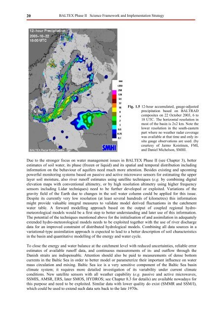
Fig. 1.5 12-hour accumulated, gauge-adjusted<br />
precipitation based on BALTRAD<br />
composites on 22 October <strong>2003</strong>, 6 to<br />
18 UTC. The horizontal resolution in<br />
most of the basin is 2x2 km. Note the<br />
lower resolution in the south-eastern<br />
part where no weather radar coverage<br />
was available at that time <strong>and</strong> only insitu<br />
gauge observations are used. (by<br />
courtesy of Jarmo Koistinen, FMI,<br />
<strong>and</strong> Daniel Michelson, SMHI.<br />
Due to the stronger focus on water management issues in <strong>BALTEX</strong> <strong>Phase</strong> <strong>II</strong> (see Chapter 3), better<br />
estimates of soil water, its phase (frozen or liquid) <strong>and</strong> its spatial <strong>and</strong> temporal distribution including<br />
information on the behaviour of aquifers need much more attention. Besides existing <strong>and</strong> upcoming<br />
powerful monitoring systems based on passive <strong>and</strong> active microwave sensors for estimating the upper<br />
layer soil moisture, also river runoff estimates using satellite techniques (e.g. by combining digital<br />
elevation maps with conventional altimetry, or by high resolution altimetry using higher frequency<br />
sensors including Lidar techniques) need to be further developed or exploited. Variations of the<br />
gravity field of the Earth due to changes in the soil water column could be applied for this issue.<br />
Despite its currently very low resolution (at least several hundreds of kilometres) this information<br />
might provide valuable integral measures to validate model derived fluctuations in the catchment<br />
water table. A forward modelling approach based on the output of coupled regional hydrometeorological<br />
models would be a first step to better underst<strong>and</strong>ing <strong>and</strong> later use of this information.<br />
The potential of the techniques mentioned above for the initialisation of <strong>and</strong> assimilation in adequately<br />
extended hydro-meteorological models needs to be exploited together with the use of river discharge<br />
data for an improved constraint of distributed hydrological models. Combining all data sources in a<br />
variational-type assimilation approach is expected to lead to a better description of soil characteristics<br />
in the basin <strong>and</strong> quantitative modelling of the energy <strong>and</strong> water cycle.<br />
To close the energy <strong>and</strong> water balance at the catchment level with reduced uncertainties, reliable error<br />
estimates of available runoff data, <strong>and</strong> continuous measurements of in- <strong>and</strong> outflow through the<br />
Danish straits are indispensable. Attention should also be paid to measurements of dense bottom<br />
currents in the Baltic Sea in order to better model or parameterize their important influence on water<br />
mass circulation <strong>and</strong> mixing. Baltic Sea ice is a very sensitive component of the Baltic Sea basin<br />
climate system; it requires more detailed investigation of its variability under current climate<br />
conditions. New satellite sensors with all weather capability (e.g. passive <strong>and</strong> active microwaves,<br />
SSMIS, AMSR, ERS, later SMOS, HYDROS; see Chapter 8.3 for details) are available nowadays for<br />
this purpose <strong>and</strong> need to be exploited. Similar data with lower quality do exist (SMMR <strong>and</strong> SSM/I),<br />
which could be used to extend such data sets back to the late 1970s.


