

BALTEX Phase II 2003 â 2012. Science Framework and ...
BALTEX Phase II 2003 â 2012. Science Framework and ...
BALTEX Phase II 2003 â 2012. Science Framework and ...

Create successful ePaper yourself
Turn your PDF publications into a flip-book with our unique Google optimized e-Paper software.
64<br />
<strong>BALTEX</strong> <strong>Phase</strong> <strong>II</strong> <strong>Science</strong> <strong>Framework</strong> <strong>and</strong> Implementation Strategy<br />
dedicated <strong>BALTEX</strong> data centre function for satellite data, which will go beyond the responsibilities of<br />
the CM-SAF. This data centre should be primarily a metadata centre which informs about available<br />
satellite data by technical information <strong>and</strong> example files, possible products <strong>and</strong> expert groups to<br />
contact, data availability, data sources, <strong>and</strong> data policy. A strong cooperation with upcoming grid<br />
projects in this area of research is essential for a satellite data centre function.<br />
At the Institute for Space <strong>Science</strong> of the Free University of Berlin, new retrieval techniques are<br />
developed <strong>and</strong> applied to different types of satellite data. To assure the quality of the products,<br />
validation exercises are performed due to cross-satellite comparisons, ground truth <strong>and</strong> aircraft<br />
measurements. The satellite data centre of the institute provides atmospheric <strong>and</strong> oceanic products<br />
derived from SEVIRI, MERIS <strong>and</strong> MODIS in near real time. All products are displayed at the<br />
internet-homepage of the Institute for Space <strong>Science</strong>. This service is not m<strong>and</strong>atory <strong>and</strong> depends on<br />
the availability of external funding. Beyond this already existing service, the Institute may be a<br />
potential c<strong>and</strong>idate to take over the responsibility for the satellite data facility.<br />
<strong>BALTEX</strong> <strong>Phase</strong> <strong>II</strong> will strongly benefit from the following new satellite data:<br />
AMSR-E (Advanced Microwave Scanning Radiometer – Earth Observing System) is a passive<br />
microwave radiometer sensing microwave radiation (brightness temperatures) at 12 channels <strong>and</strong> 65<br />
frequencies ranging from 6.9 to 89 GHz. AMSR-E estimates geophysical parameters supporting<br />
several global change science <strong>and</strong> monitoring efforts, including precipitation, oceanic water vapour,<br />
cloud water, near-surface wind speed, sea surface temperature, soil moisture snow cover, <strong>and</strong> sea ice<br />
parameters. All of these measurements are critical to underst<strong>and</strong>ing the earth climate, <strong>and</strong> thus for<br />
<strong>BALTEX</strong> <strong>Phase</strong> <strong>II</strong>.<br />
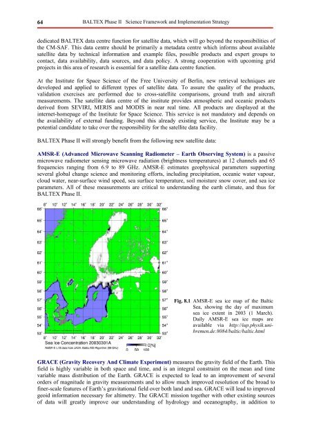
Fig. 8.1 AMSR-E sea ice map of the Baltic<br />
Sea, showing the day of maximum<br />
sea ice extent in <strong>2003</strong> (1 March).<br />
Daily AMSR-E sea ice maps are<br />
available via http://iup.physik.unibremen.de:8084/baltic/baltic.html<br />
GRACE (Gravity Recovery And Climate Experiment) measures the gravity field of the Earth. This<br />
field is highly variable in both space <strong>and</strong> time, <strong>and</strong> is an integral constraint on the mean <strong>and</strong> time<br />
variable mass distribution of the Earth. GRACE is expected to lead to an improvement of several<br />
orders of magnitude in gravity measurements <strong>and</strong> to allow much improved resolution of the broad to<br />
finer-scale features of Earth’s gravitational field over both l<strong>and</strong> <strong>and</strong> sea. GRACE will lead to improved<br />
geoid information necessary for altimetry. The GRACE mission together with other existing sources<br />
of data will greatly improve our underst<strong>and</strong>ing of hydrology <strong>and</strong> oceanography, in addition to


