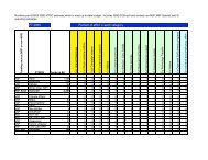
Ground Truth Studies Teacher Handbook - Aspen Global Change ...
Ground Truth Studies Teacher Handbook - Aspen Global Change ...
Ground Truth Studies Teacher Handbook - Aspen Global Change ...

Create successful ePaper yourself
Turn your PDF publications into a flip-book with our unique Google optimized e-Paper software.
Glossary (continued)<br />
Turbid<br />
opaque with suspended matter, such as of a sediment-laden stream flowing into a lake. ●<br />
USGS<br />
United States Geological Survey. ▲<br />
Vector<br />
a data structure for representing point and line data by means of 2- or 3-dimensional geometric (Cartesian x, y or x, y, z)<br />
coordinates. In connection with GIS and computer graphics, “vector” can refer to a set of line segments joined end to end<br />
to make a curved line in space. ▲<br />
Verification<br />
is establishing the accuracy of data by checking it against an independent means of collecting information; confirmation,<br />
validation. Often ground truth observations and measurements are verification for remotely sensed data.<br />
Video Digitizing Board<br />
a video interface circuit board that samples or frame-grabs a video frame and constructs a digital image. Video digitizing<br />
boards are slower than video capture boards, but can be used for non-standard, higher resolution video sources. (See also<br />
Frame-Grabbing) ▲<br />
Watershed Seed Point<br />
the point at the base of a watershed into which all points in the watershed drain; often taken as the mouth of a stream or<br />
river. ▲<br />
Watershed<br />
the entire area above a given point (called the watershed “seed”) that drains into that point. ▲<br />
X-Y Digitizing Table<br />
a peripheral device for manually translating line and point data (like engineering and technical drawings) into some<br />
computer format (usually vector or CAD). The drawing is secured to the tablet, and the operator positions the device’s<br />
cursor (which may look like a pen or a computer mouse with a crosshair lens) over lines and other elements, clicking a<br />
button or pressing a key to record a coordinate. ▲<br />
■ Glossary: Carbon Dioxide and Climate, ORNL/CDIAC-39, Oak Ridge National Library, Oak Ridge, Tennessee (1990)<br />
● Glossary of Technical Terms, Mission to Earth: Landsat Views the World. Scientific and Technical Information<br />
Office, National Aeronautics and Space Administration, Washington, D.C. (1976 and 1978)<br />
▲ Glossary, A Guide to Map and Image Processing, MicroImages, Inc., Lincoln, Nebraska (1991)<br />
✱ Glossary, Project WILD: Secondary Activity Guide, Project WILD, Boulder, Colorado (1983)<br />
❖ Webster’s Third New International Dictionary, G. & C. Merriam Company, Publishers, Springfield,<br />
Massachusetts (1971)<br />
Uncited definitions by <strong>Aspen</strong> <strong>Global</strong> <strong>Change</strong> Institute.<br />
© ASPEN GLOBAL CHANGE INSTITUTE 1995 GROUND TRUTH STUDIES<br />
129

![View Powerpoint Slides [PDF]](https://img.yumpu.com/32486693/1/190x146/view-powerpoint-slides-pdf.jpg?quality=85)

![View Powerpoint Slides [PDF]](https://img.yumpu.com/29411106/1/190x143/view-powerpoint-slides-pdf.jpg?quality=85)