Ground Truth Studies Teacher Handbook - Aspen Global Change ...
Ground Truth Studies Teacher Handbook - Aspen Global Change ...
Ground Truth Studies Teacher Handbook - Aspen Global Change ...

You also want an ePaper? Increase the reach of your titles
YUMPU automatically turns print PDFs into web optimized ePapers that Google loves.
<strong>Handbook</strong> Cover<br />
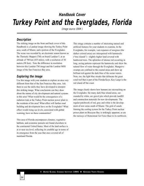
Turkey Point and the Everglades, Florida<br />
(image source: ERIM )<br />
Description<br />
The striking image on the front and back cover of this<br />
<strong>Handbook</strong> is a Landsat image showing the Turkey Point<br />
area, south of Miami, and a portion of the Everglades.<br />
The scene was recorded by an electronic sensor known as<br />
the Thematic Mapper (TM) on board Landsat 5, at an<br />
altitude of 700 km (435 miles), with a resolution of 30<br />
meters (98 feet). Note the difference in resolution<br />
between this Landsat TM image and the Landsat MSS<br />
image of the San Francisco Bay area.<br />
Exploring the Image<br />
Use this image with your students to explore an area very<br />
different from that of the San Francisco Bay area. Ask<br />
them to use the skills they have developed to interpret<br />
this striking image. What conclusions can they draw<br />
about the nature of city development and natural systems<br />
in this area? What would be the consequences of a<br />
radiation leak at the Turkey Point nuclear power plant to<br />
the residents of the area? What effect will further road<br />
building and development have on the Everglades? What<br />
effect would rising sea levels, associated with global<br />
warming, have on these communities?<br />
This area of Florida encompasses climates, vegetative<br />
habitats, and economic pursuits not found elsewhere in<br />
the continental United States. Most of the land surface is<br />
at or near sea level, reflecting its youthful age in terms of<br />
its emergence from the seas that once covered all of<br />
mainland Florida.<br />
This image contains a number of interesting natural and<br />
artificial features for your students to examine. In the<br />
Everglades, for example, vast expanses of sawgrass (the<br />
darker colored areas) are interspersed with hammocks<br />
(“tree islands”) - slightly higher land covered with<br />
hardwood trees. The splotches of intense red occurring in<br />
long, arcing patterns represent the hammocks and show the<br />
natural flow of water through the Everglades. Mangrove<br />
swamps are confined to the coastal areas and show up<br />
brilliant red against the dark blue of the ocean waters.<br />
Note, too, the light blue streaks that delineate the great<br />
coral reef that is part of the Florida Keys. Key Largo is the<br />
red island off the coast.<br />
The image clearly shows how humans are encroaching on<br />
the Everglades: the many dark blue inland areas, surrounded<br />
by white, are gravel pits which provide landfill<br />
and construction materials for new developments. The<br />
regular patchwork of red, gray and white is the development<br />
of new areas south of Miami. The grid of canals<br />
forming the cooling system for the Turkey Point nuclear<br />
power plant on Biscayne Bay is strikingly apparent, as are<br />
the runways of Homestead Air Force Base to its northwest.<br />
© ASPEN GLOBAL CHANGE INSTITUTE 1995 GROUND TRUTH STUDIES<br />
64

![View Powerpoint Slides [PDF]](https://img.yumpu.com/32486693/1/190x146/view-powerpoint-slides-pdf.jpg?quality=85)

![View Powerpoint Slides [PDF]](https://img.yumpu.com/29411106/1/190x143/view-powerpoint-slides-pdf.jpg?quality=85)