Ground Truth Studies Teacher Handbook - Aspen Global Change ...
Ground Truth Studies Teacher Handbook - Aspen Global Change ...
Ground Truth Studies Teacher Handbook - Aspen Global Change ...
Create successful ePaper yourself
Turn your PDF publications into a flip-book with our unique Google optimized e-Paper software.
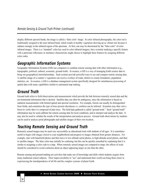
Remote Sensing & <strong>Ground</strong> <strong>Truth</strong> Primer (continued)<br />
display different spectral bands, the image is called a ‘false color’ image. In color infrared photography, the color red is<br />
traditionally assigned to the near infrared band, which results in healthy vegetation showing up as vibrant red, because it<br />
radiates strongly in the infrared region of the spectrum. At first, one may be disoriented by the “false color” of color<br />
infrared images. There is a “standard” color key used in color infrared imagery, but a scientist studying a specific feature<br />
with a particular reflectance or emittance characteristic might choose to highlight these features by assigning different<br />
color codes.<br />
Geographic Information Systems<br />
Geographic Information Systems (GIS) use computers to combine remote sensing data with other information (e.g.,<br />
topographic, political, cultural, economic, ground truth). In essence, a GIS is a way of managing Earth science data to<br />
bring out geographical interrelationships. Such systems provide powerful ways to use and compare remote sensing data.<br />
A satellite image of a country’s vegetation can receive overlays of roads, district or county boundaries, population<br />
statistics, etc. In essence, a GIS is a database management system specifically designed for simultaneous processing of<br />
spatial data with many capabilities similar to automated map making.<br />
<strong>Ground</strong> <strong>Truth</strong><br />
<strong>Ground</strong> truth refers to field observations and measurements which provide the link between remotely sensed data and the<br />
environmental information that is desired. Satellite data can often be ambiguous, since the information is based on<br />
radiation measurements with limited spatial and spectral resolution. For example, forests can usually be distinguished<br />
from fields, and sometimes the type of trees present (deciduous vs. conifers) can be inferred. Scientists may then visit a<br />
forest to verify that it is composed of pine trees. The field data gathered is called “ground truth.” Such “ground truth”<br />
information may be used calibrate the remote sensing data for local conditions, and to interpret and analyze the data. It<br />
may also be used to validate the results of the interpretation and analysis process. <strong>Ground</strong> truth observations by students<br />
can be used to analyze aerial photographs and satellite images of their own location.<br />
Teaching Remote Sensing and <strong>Ground</strong> <strong>Truth</strong><br />
Remotely sensed images may be used very successfully as educational tools with students of all ages. It is sometimes<br />
useful to begin with images closest to your neighborhood and progress to images obtained from greater distances. For<br />
example, start with hand-held photos and then move to low-altitude aerial photos, to high-altitude aerial photos, and then<br />
to satellite images. The false color may initially be confusing, but this can be quickly remedied by explaining that it is<br />
similar to assigning a color code to a map. When remotely sensed images are compared to maps, the effects of scale<br />
should be considered to avoid confusion about an object appearing larger on one than the other.<br />
Remote sensing and ground truthing are activities that make use of knowledge and skills which students acquire from<br />
many traditional school subjects. Their improved ability to “see” and understand their world can bring them closer to<br />
experiencing the interdependence of all life and the complex systems of planet Earth.<br />
34<br />
© ASPEN GLOBAL CHANGE INSTITUTE 1995 GROUND TRUTH STUDIES



![View Powerpoint Slides [PDF]](https://img.yumpu.com/32486693/1/190x146/view-powerpoint-slides-pdf.jpg?quality=85)

![View Powerpoint Slides [PDF]](https://img.yumpu.com/29411106/1/190x143/view-powerpoint-slides-pdf.jpg?quality=85)
