Ground Truth Studies Teacher Handbook - Aspen Global Change ...
Ground Truth Studies Teacher Handbook - Aspen Global Change ...
Ground Truth Studies Teacher Handbook - Aspen Global Change ...

You also want an ePaper? Increase the reach of your titles
YUMPU automatically turns print PDFs into web optimized ePapers that Google loves.
Remote Sensing & <strong>Ground</strong> <strong>Truth</strong> Primer (continued)<br />
Sensors<br />
In the process of remote sensing, information about our environment is conveyed by electromagnetic energy and received<br />
and recorded by sensors. Most modern technological sensors have counterparts that occur in nature. For example, the<br />
photographic camera and the human eye both sense visible light; the microphone and the ear pick up sound waves; smoke<br />
alarms and noses both sense molecular dispersions we call odors. The sensors used in remote sensing are primarily<br />
sensitive to UV, visible, infrared, and microwave wavelengths; they sense and record data in these spectral bands. These<br />
data are then generally converted to image form for print or computer viewing and enhancement. Radar senses in the<br />
microwave region of the spectrum; the Landsat thematic mapper sensor senses in the visible and near to mid infrared.<br />
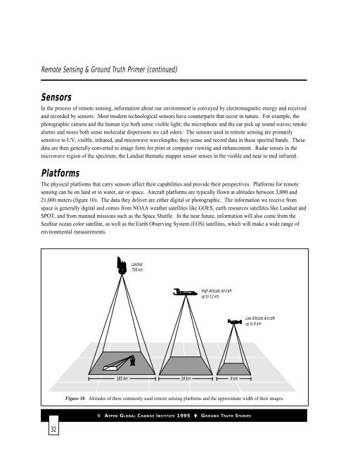
Platforms<br />
The physical platforms that carry sensors affect their capabilities and provide their perspectives. Platforms for remote<br />
sensing can be on land or in water, air or space. Aircraft platforms are typically flown at altitudes between 3,000 and<br />
21,000 meters (figure 10). The data they deliver are either digital or photographic. The information we receive from<br />
space is generally digital and comes from NOAA weather satellites like GOES, earth resources satellites like Landsat and<br />
SPOT, and from manned missions such as the Space Shuttle. In the near future, information will also come from the<br />
SeaStar ocean color satellite, as well as the Earth Observing System (EOS) satellites, which will make a wide range of<br />
environmental measurements.<br />
Landsat<br />
700 km<br />
Landsat<br />
700 km<br />
High Altitude Aircraft<br />
High<br />
up<br />
Altitude<br />
to 12 km<br />
Aircraft<br />
up to 20 km<br />
Low Altitude Aircraft Aircraft<br />
up to 10 6 km km<br />
185 km<br />
18 km<br />
9 km<br />
Figure 10: Altitudes of three commonly used remote sensing platforms and the approximate width of their images.<br />
© ASPEN GLOBAL CHANGE INSTITUTE 1995 GROUND TRUTH STUDIES<br />
32

![View Powerpoint Slides [PDF]](https://img.yumpu.com/32486693/1/190x146/view-powerpoint-slides-pdf.jpg?quality=85)

![View Powerpoint Slides [PDF]](https://img.yumpu.com/29411106/1/190x143/view-powerpoint-slides-pdf.jpg?quality=85)