

Assessing e Values and Management of the NSW Travelling ... - Land
Assessing e Values and Management of the NSW Travelling ... - Land
Assessing e Values and Management of the NSW Travelling ... - Land

Create successful ePaper yourself
Turn your PDF publications into a flip-book with our unique Google optimized e-Paper software.
ASSESSING THE VALUES AND MANAGEMENT OF THE <strong>NSW</strong> TRAVELLING STOCK RESERVE<br />
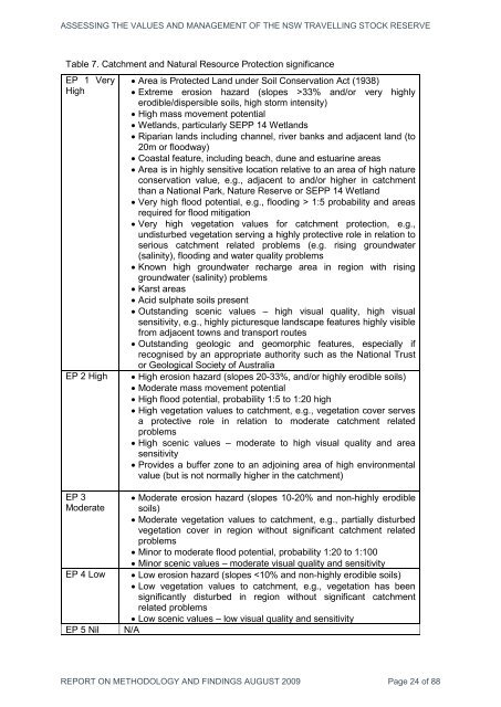
Table 7. Catchment <strong>and</strong> Natural Resource Protection significance<br />
EP 1 Very<br />
High<br />
EP 2 High<br />
• Area is Protected L<strong>and</strong> under Soil Conservation Act (1938)<br />
• Extreme erosion hazard (slopes >33% <strong>and</strong>/or very highly<br />
erodible/dispersible soils, high storm intensity)<br />
• High mass movement potential<br />
• Wetl<strong>and</strong>s, particularly SEPP 14 Wetl<strong>and</strong>s<br />
• Riparian l<strong>and</strong>s including channel, river banks <strong>and</strong> adjacent l<strong>and</strong> (to<br />
20m or floodway)<br />
• Coastal feature, including beach, dune <strong>and</strong> estuarine areas<br />
• Area is in highly sensitive location relative to an area <strong>of</strong> high nature<br />
conservation value, e.g., adjacent to <strong>and</strong>/or higher in catchment<br />
than a National Park, Nature Reserve or SEPP 14 Wetl<strong>and</strong><br />
• Very high flood potential, e.g., flooding > 1:5 probability <strong>and</strong> areas<br />
required for flood mitigation<br />
• Very high vegetation values for catchment protection, e.g.,<br />
undisturbed vegetation serving a highly protective role in relation to<br />
serious catchment related problems (e.g. rising groundwater<br />
(salinity), flooding <strong>and</strong> water quality problems<br />
• Known high groundwater recharge area in region with rising<br />
groundwater (salinity) problems<br />
• Karst areas<br />
• Acid sulphate soils present<br />
• Outst<strong>and</strong>ing scenic values – high visual quality, high visual<br />
sensitivity, e.g., highly picturesque l<strong>and</strong>scape features highly visible<br />
from adjacent towns <strong>and</strong> transport routes<br />
• Outst<strong>and</strong>ing geologic <strong>and</strong> geomorphic features, especially if<br />
recognised by an appropriate authority such as <strong>the</strong> National Trust<br />
or Geological Society <strong>of</strong> Australia<br />
• High erosion hazard (slopes 20-33%, <strong>and</strong>/or highly erodible soils)<br />
• Moderate mass movement potential<br />
• High flood potential, probability 1:5 to 1:20 high<br />
• High vegetation values to catchment, e.g., vegetation cover serves<br />
a protective role in relation to moderate catchment related<br />
problems<br />
• High scenic values – moderate to high visual quality <strong>and</strong> area<br />
sensitivity<br />
• Provides a buffer zone to an adjoining area <strong>of</strong> high environmental<br />
value (but is not normally higher in <strong>the</strong> catchment)<br />
EP 3<br />
Moderate<br />
EP 4 Low<br />
EP 5 Nil<br />
• Moderate erosion hazard (slopes 10-20% <strong>and</strong> non-highly erodible<br />
soils)<br />
• Moderate vegetation values to catchment, e.g., partially disturbed<br />
vegetation cover in region without significant catchment related<br />
problems<br />
• Minor to moderate flood potential, probability 1:20 to 1:100<br />
• Minor scenic values – moderate visual quality <strong>and</strong> sensitivity<br />
• Low erosion hazard (slopes


