Title 16 - BUILDING AND CONSTRUCTION ... - King County
Title 16 - BUILDING AND CONSTRUCTION ... - King County
Title 16 - BUILDING AND CONSTRUCTION ... - King County

You also want an ePaper? Increase the reach of your titles
YUMPU automatically turns print PDFs into web optimized ePapers that Google loves.
ural stewardship plan or the farm management plan;<br />
2. Subsection A. of this section does not apply to a lot within a subdivision or short subdivision:<br />
a. Approved with clearing restrictions in accordance with K.C.C. <strong>16</strong>.82.152; or<br />
b. In the Bear Creek, Issaquah Creek or May Creek basins that was approved with clearing<br />
restrictions in accordance with this section as it existed prior to January 1, 2005;<br />
3. On a lot within a subdivision or short subdivision that is not covered by subsection C.2. of this<br />
section, any land located in an open space tract created as part of the subdivision or short subdivision<br />
shall be credited to the individual lots in the subdivision or short subdivision on a prorated basis according<br />
to the size of each lot in relation the entire area of the subdivision or short subdivision;<br />
4. The area within landslide or steep slope hazard areas, wetlands, aquatic areas and the<br />
buffers for these critical areas may be counted towards meeting the requirements of subsection A. of this<br />
section;<br />
5. Clearing in areas encumbered by a utility corridor, or easement for a public road or trail rightsof-way<br />
or an access easement shall not be counted toward the cleared area limit;<br />
6. Clearing standards for mining uses shall be determined through the clearing and grading<br />
permit review process; and<br />
7. Clearing that is the minimum necessary to provide for the relocation of equestrian community<br />
trails shall not be counted towards the cleared area limit.<br />
D. The director may modify or wave subsection of this section for a development proposal that<br />
meets the following conditions:<br />
1. The development proposal consists of one or more of the following uses:<br />
a. government services listed in K.C.C. 21A.08.060;<br />
b. educational services listed in K.C.C. 21A.08.050;<br />
c. parks as listed in K.C.C. 21A.08.040 when located adjacent to an existing or proposed<br />
school;<br />
d. libraries listed in K.C.C. 21A.08.040; and<br />
e. road projects that are not part of a larger development proposal;<br />
2. The development proposal site is not located in a designated regionally significant resource<br />
area, except for utility or road corridors for which the applicant demonstrate that there is no feasible<br />
alternative or that the development proposal is within an existing maintained corridor. If only a portion of<br />
the project is located within a designated regionally significant resource area, this subsection applies to<br />
that portion of the project located outside of the designated regionally significant resource area; and<br />
3. To the maximum extent practical, the project locates structures in already cleared areas of<br />
the site and clears the minimum necessary to accommodate the proposed use which includes all the<br />
allowed ballfields, playfields, other facilities, and spaces proposed by the public agency to carry out its<br />
public function.<br />
E. The standards of this section shall be established at the time of permit application. The area<br />
required to remain uncleared shall be designated on the site plan approved by the department.<br />
F. Areas that are required to remain uncleared under this section shall be maintained by the<br />
property owner as a resource area. The uses permitted in the resource area shall not prevent the longterm<br />
purpose of the resource area to promote forest cover and shall include uses such as:<br />
1. Except in areas regulated by a source described in subsection B.3. of this section, forest<br />
practices in accordance with a county-approved forest management plan;<br />
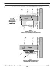
2. Passive recreation uses and related facilities, including pedestrian, equestrian community and<br />
bicycle trails, nature viewing areas, fishing and camping areas, and other similar uses that do not require<br />
permanent structures, if:<br />
a. clearing and soil compaction associated with these uses and facilities does not exceed eight<br />
percent of the area of the resource area; and<br />
b. within wildlife habitat corridors, trail widths shall be the minimum allowed under adopted trail<br />
standards and no other recreation uses shall be permitted in an area of the corridor at least one hundred<br />
fifty feet in width;<br />
3. Utilities and utility easements, including surface water facilities, if the facilities are within or<br />
adjacent to existing road or utility easements to the maximum extent practical;<br />
4. Pruning or removing hazard trees or removing downed trees;<br />
5. Reducing the danger from wildfire by following best management practices approved by the<br />
<strong>King</strong> <strong>County</strong> fire marshal;<br />
a. removal of limbs within ten feet of the ground to prevent movement of fire from ground level<br />
to treetops; and<br />
b. removal of dead trees or branches overhanging a residence; and<br />
6. Removal of noxious or invasive vegetation.<br />
G. Before approving a development permit application for a parcel that has been cleared in<br />
violation of the clearing standards in effect at the time of the clearing, the department shall require the<br />
applicant submit to the department and implement a restoration plan to restore trees, understory