

Download PDF - Anchor Environmental
Download PDF - Anchor Environmental
Download PDF - Anchor Environmental

Create successful ePaper yourself
Turn your PDF publications into a flip-book with our unique Google optimized e-Paper software.
The first time in recorded history that the Uilkraals Estuary became closed for a long period of<br />
time was in January 2009. It re-opened six months later for a short period but closed again for<br />
an extended period in December 2009. Water storage in the Kraaibosch Dam, approximately<br />
10 km upstream from the estuary, has significantly altered the natural freshwater in-flows to<br />
the estuary while agricultural activities in the upper catchment have introduced an increased<br />
sediment load into the estuary, ultimately resulting in reduced flow over time and an increased<br />
likelihood of mouth closure of the estuary in low flow periods.<br />
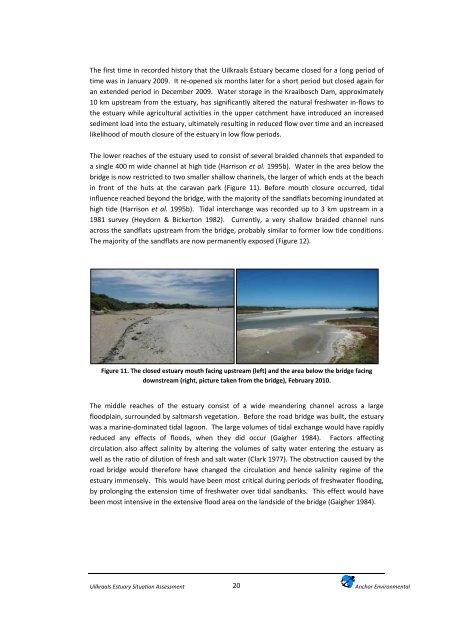
The lower reaches of the estuary used to consist of several braided channels that expanded to<br />
a single 400 m wide channel at high tide (Harrison et al. 1995b). Water in the area below the<br />
bridge is now restricted to two smaller shallow channels, the larger of which ends at the beach<br />
in front of the huts at the caravan park (Figure 11). Before mouth closure occurred, tidal<br />
influence reached beyond the bridge, with the majority of the sandflats becoming inundated at<br />
high tide (Harrison et al. 1995b). Tidal interchange was recorded up to 3 km upstream in a<br />
1981 survey (Heydorn & Bickerton 1982). Currently, a very shallow braided channel runs<br />
across the sandflats upstream from the bridge, probably similar to former low tide conditions.<br />
The majority of the sandflats are now permanently exposed (Figure 12).<br />
Figure 11. The closed estuary mouth facing upstream (left) and the area below the bridge facing<br />
downstream (right, picture taken from the bridge), February 2010.<br />
The middle reaches of the estuary consist of a wide meandering channel across a large<br />
floodplain, surrounded by saltmarsh vegetation. Before the road bridge was built, the estuary<br />
was a marine-dominated tidal lagoon. The large volumes of tidal exchange would have rapidly<br />
reduced any effects of floods, when they did occur (Gaigher 1984). Factors affecting<br />
circulation also affect salinity by altering the volumes of salty water entering the estuary as<br />
well as the ratio of dilution of fresh and salt water (Clark 1977). The obstruction caused by the<br />
road bridge would therefore have changed the circulation and hence salinity regime of the<br />
estuary immensely. This would have been most critical during periods of freshwater flooding,<br />
by prolonging the extension time of freshwater over tidal sandbanks. This effect would have<br />
been most intensive in the extensive flood area on the landside of the bridge (Gaigher 1984).<br />
Uilkraals Estuary Situation Assessment<br />
20<br />
<strong>Anchor</strong> <strong>Environmental</strong>


