- Page 3 and 4:
091-00005-001 REV B EFD1000 PFD Pil
- Page 5 and 6:
A Using new part number 091-00005-0
- Page 7 and 8:
Table of Contents Document Revision
- Page 9 and 10:
4.2.3.5. Decision Height...........
- Page 11 and 12:
Table of Figures Figure 1 EFD1000 P
- Page 13 and 14:
Figure 3-24 Selected Airspeed Bug E
- Page 15 and 16:
Figure 4-72 Menu, GENERAL SETTINGS,
- Page 17 and 18:
Figure 6-4 Battery Status..........
- Page 19 and 20:
Chapter 6 Table 6-1 Warning Annunci
- Page 21 and 22:
Enable Auto Range .................
- Page 23 and 24:
Copyrights and Trademarks Copyright
- Page 25 and 26:
LIMITED WARRANTY Aspen Avionics, In
- Page 27 and 28:
11. Extension of Warranty. No exten
- Page 29 and 30:
XM WX Satellite Radio Service Agree
- Page 31 and 32:
Conventions The following conventio
- Page 33 and 34:
Color Philosophy Table 2 provides t
- Page 35 and 36:
Example Graphics The example graphi
- Page 37 and 38:
Chapter 1 Welcome and Introduction
- Page 39 and 40:
You can even add another MFD, repla
- Page 41 and 42:
1.1.1. EFD1000 Display The EFD1000
- Page 43 and 44:
1.1.4. Analog Converter Unit (ACU)
- Page 45 and 46:
Chapter 2 Controls and Display The
- Page 47 and 48:
DATABAR 38 True Airspeed (TAS) 39 B
- Page 49 and 50:
Once set, you can either press the
- Page 51 and 52:
Left Knob SYNC Action IAS CRS Set t
- Page 53 and 54:
2.2.2. Navigation Source Select But
- Page 55 and 56:
2.2.3. Hot Keys The five buttons al
- Page 57 and 58:
Hot Key DESCRIPTION OPTIONS LTNG NX
- Page 59 and 60:
Each menu page displays up to five
- Page 61 and 62:
Edit Main Menu Items 1. Access the
- Page 63 and 64:
2.2.5. Range Button When the MAP is
- Page 65 and 66:
EFD1000 PFD is their first real exp
- Page 67 and 68:
ATTITUDE DISPLAY 16 Attitude Displa
- Page 69 and 70:
2.3.2.2. Airspeed Tape and Bug Airs
- Page 71 and 72:
2.3.2.4. Instrument Approach Indica
- Page 73 and 74:
2.3.4. Navigation Display The lower
- Page 75 and 76:
2.3.4.1. Direction Indicator (Magne
- Page 77 and 78:
2.3.4.2. Horizontal Situation Indic
- Page 79 and 80:
2.3.4.6. Bearing Pointers One or tw
- Page 81 and 82:
2.3.4.9. Situational Awareness Map
- Page 83 and 84:
Chapter 3 Flying the EFD1000 Pro PF
- Page 85 and 86:
3.1. Quick Controls Overview Chapte
- Page 87 and 88:
3.2. Example Flight Scenario This s
- Page 89 and 90:
Turn the Avionics Master ON. Until
- Page 91 and 92:
Next, since we’ll be departing fr
- Page 93 and 94:
Select Map Declutter Level • Push
- Page 95 and 96:
Because we need all the help we can
- Page 97 and 98:
Set the Altitude Alerter 1. Press t
- Page 99 and 100:
3.2.2. Departure As we start the ta
- Page 101 and 102:
3.2.3. En Route Albuquerque Center
- Page 103 and 104:
Check TAS, GS, and winds and temper
- Page 105 and 106:
We’re all set up for the approach
- Page 107 and 108:
Even though the PFD Navigation Sour
- Page 109 and 110:
3.3. Conclusion The EFD1000 Pro PFD
- Page 111 and 112:
Chapter 4 Reference Guide The EFD10
- Page 113 and 114:
4.1.1. Attitude The Aspen ADAHRS at
- Page 115 and 116:
In summary, loss or degradation of
- Page 117 and 118:
Two minutes after detection, a FREE
- Page 119 and 120:
4.2.1.1. Roll Scale The Roll Scale
- Page 121 and 122:
Indicated airspeed is displayed in
- Page 123 and 124:
4.2.2.2. Airspeed Display In some c
- Page 125 and 126:
4.2.3.1. Barometric Pressure Adjust
- Page 127 and 128:
Set Altitude Bug 1. Press the Right
- Page 129 and 130:
Once the MIN data field value is se
- Page 131 and 132:
4.2.3.6. Altitude Display In some c
- Page 133 and 134:
4.3. Data Bar The Data Bar presents
- Page 135 and 136:
4.3.5. Barometric Pressure Setting
- Page 137 and 138:
All instrument values on the HSI ar
- Page 139 and 140:
Select Compass Type • Push the 36
- Page 141 and 142:
4.4.3. TO/FROM Indicator Each of th
- Page 143 and 144:
4.4.5. CDI Navigation Source When t
- Page 145 and 146:
Whenever the CDI navigation source
- Page 147 and 148:
4.4.6. Auto Course The pilot can ei
- Page 149 and 150:
4.4.8. Bearing Pointer Source Selec
- Page 151 and 152:
Select the Single-Line Bearing Poin
- Page 153 and 154:
4.4.10. Aircraft Heading Display Th
- Page 155 and 156:
4.4.12.1. Map Declutter and Range T
- Page 157 and 158:
Auto range is only available when a
- Page 159 and 160:
4.5. Lateral and Vertical Deviation
- Page 161 and 162:
4.6. Vertical Speed Indicator When
- Page 163 and 164:
4.7.1. GPS Steering (GPSS) GPS Stee
- Page 165 and 166:
When GPSS is Enabled, and the autop
- Page 167 and 168:
Several conditions can cause GPSS t
- Page 169 and 170:
NAV Mode Operation - GPS Navigation
- Page 171 and 172:
APPR Mode Operation - GPS or GPS/RN
- Page 173 and 174:
GPS APPR Mode Operation - WAAS GPS
- Page 175 and 176:
Hot Key Display Symbol Annunciation
- Page 177 and 178:
NEXRAD coverage displays using the
- Page 179 and 180:
The data age (except Puerto Rico NE
- Page 181 and 182:
4.8.3.1. Traffic Symbols The EFD100
- Page 183 and 184:
When multiple traffic symbols parti
- Page 185 and 186: Chapter 5 Customizing the EFD1000 P
- Page 187 and 188: KEY DESCRIPTION OPTIONS 360° Fligh
- Page 189 and 190: KEY DESCRIPTION OPTIONS KEY DESCRIP
- Page 191 and 192: KEY DESCRIPTION 1 US NEXRAD Age OPT
- Page 193 and 194: KEY DESCRIPTION OPTIONS Operating f
- Page 195 and 196: 5.2. Customizing the Map (Declutter
- Page 197 and 198: Feature Group & Layer Order (top to
- Page 199 and 200: Vspeed DEFINITION PRE-SET BANDS Vlo
- Page 201 and 202: On aircraft with flaps, setting the
- Page 203 and 204: 5.4. LCD Brightness Control The LCD
- Page 205 and 206: Chapter 6 Expanded Emergency and Ab
- Page 207 and 208: Blocked Pitot or Static Line Suspec
- Page 209 and 210: On the initial climb-out after take
- Page 211 and 212: 6.2. Frequent or Persistent CROSS C
- Page 213 and 214: 6.5. Loss of Aircraft Electrical Po
- Page 215 and 216: 6.6. GPS Failures and RSM Emergency
- Page 217 and 218: 6.8. In-Flight AHRS Reset In the un
- Page 219 and 220: 6.9. GPSS Operation, Annunciations,
- Page 221 and 222: 6.10. Warning, Caution, and Advisor
- Page 223 and 224: CAUTION Figure 6-18 Cross Check Att
- Page 225 and 226: CAUTION Figure 6-27 GPSS Source Los
- Page 227 and 228: ADVISORY Associated with the GPS co
- Page 229 and 230: Chapter 7 Appendices 7.1. Operating
- Page 231 and 232: 7.3. Specifications 7.3.1. EFD1000
- Page 233 and 234: 7.3.2. Remote Sensor Module (RSM) W
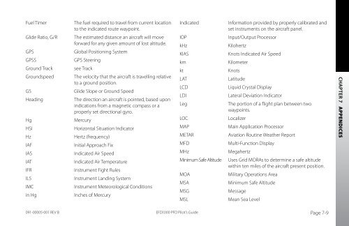
- Page 235: 7.4. Glossary ºC Degrees Celsius
- Page 239 and 240: 7.5. Index Symbols 1/2, Hot Key ...
- Page 241 and 242: GPS Invalid .......................
- Page 243 and 244: Operation, Annunciations, and Autop
- Page 245 and 246: Vertical Speed Indicator ..........
- Page 247 and 248: Weather Data ......................
- Page 250: Aspen Avionics, Inc. 5001 Indian Sc