

PDF COPY - Manuel berberian
PDF COPY - Manuel berberian
PDF COPY - Manuel berberian

Create successful ePaper yourself
Turn your PDF publications into a flip-book with our unique Google optimized e-Paper software.
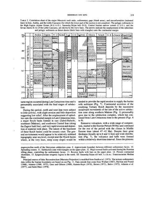
BERBERIAN AND KING 219<br />
TABLE 2. Correlation chart of the major Mesozoic rock units, sedimentary gaps (blank areas), and unconformities (indented<br />
lines) in Iran, Arabia, and the Little Caucasus (for which the lower part of the section is not complete). The pelagic sediments<br />
the High-Zagros Alpine Ocean (H.Z.A.O.), Sanandaj-Sirjan belt (S-S), Central Iranian narrow oceans (C.I.O.), and<br />
Sevan-Akera (S-A) of the Little Caucasus, are shown by the wavy lines. The arrows indicate the emplacement of the ophiolites<br />
and pelagic sediments as thrust sheets (thick lines with triangles) onto the continental margin<br />
Arabia Zagros H-Z H.Z.A.O. I ST,~q I C.I.O. IC~ntrcal I. Alborz Talesh S-A L.Cauca’s<br />
same region occurred during Late Cretaceous time and is<br />
presumably associated with the final stages of subduction.<br />
During this period, north and west Iran were subject<br />
to little activity, with slight erosion and little deposition<br />
suggesting low relief. After the emplacement of ophiolites<br />
onto the continental margin in Late Cretaceous time,<br />
a major flysch basin formed in east (Zabol-Baluch),<br />
southeast (Makran), and southwest Central Iran (along<br />
the Zagros fault line), and very rapid erosion and deposition<br />
of material took place. The nature of the basement<br />
of these flysch basins could be oceanic crust. The general<br />
environment would appear to be relatively subdued<br />
topography near sea level, except near the flysch basins<br />
where, at the very least, steep scarp slopes would be<br />
needed to provide the rapid erosion to supply the basins<br />
with sediment (Fig. 7). Continental accretion of the<br />
overlying Tertiary flysch deposits by the successive<br />
oceanward movements of the site of the active subduction<br />
zone along southern Makran (Fig. 1) presumably<br />
gave rise to the subduction complex, which has continued<br />
from Late Cretaceous time to the present (Figs.<br />
to 9).<br />
Extensive volcanism, with a wide range of composition,<br />
started in the Eocene Period (50 Ma) and continued<br />
for the rest of the period with the climax in Middle<br />
Eocene time (about 47-42 Ma). Despite their great<br />
thickness (locally up to 6 and 12 km) and wide distribution<br />
(Fig. 7), the volcanics and tufts were formed<br />
within a relatively short time interval. Since the plutonic<br />
eugeosyncline north of the Hercynian subduction zone. 9. Approximate boundary between different sedimentary facies. 10.<br />
Spreading centres. 11. Subduction zone with triangles on the upper plate. 12. Major normal faults activated during the Permian<br />
rifting phase, controlling the sedimentary facies. 13. Reverse faults with bars on the upper plate. 14. Present continental<br />
shorelines. 15. Epigeosyncline orogenic region in the north. SS: Sanandaj-Sirjan rift belt. t.c.m.m.: Transcaucasian Median<br />
Mass.<br />
Principal sources of data: Reconstruction (Mercator Projection) is modified from Smithetal. (1973). The tectono-sedimentary<br />
data within the Iranian boundaries are based on our Fig. 11. Data outside Iran come from Wolfart (1967), Nalvkin and Posner<br />
(1968), Adamia (1968, 1975), Gass and Gibson (1969), Kamen-Kaye (1970), Brown (1972), Belov (1972), et al.<br />
(1977), and Saint-Marc (1978).


