

PDF COPY - Manuel berberian
PDF COPY - Manuel berberian
PDF COPY - Manuel berberian

You also want an ePaper? Increase the reach of your titles
YUMPU automatically turns print PDFs into web optimized ePapers that Google loves.
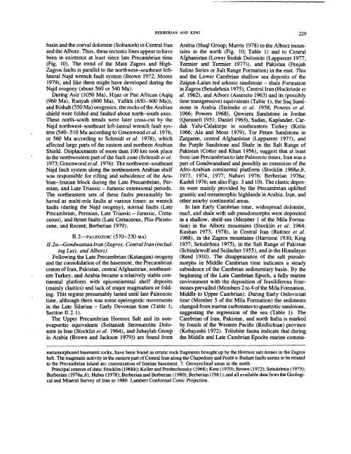
asin and the coeval dolomite (Soltanieh) in Central Iran<br />
and the Alborz. Thus, these tectonic lines appear to have<br />
been in existence at least since late Precambrian time<br />
(Fig. 10). The trend of the Main Zagros and High-<br />
Zagros faults is parallel to the northwest-southeast leftlateral<br />
Najd wrench fault system (Brown 1972; Moore<br />
1979), and like them might have developed during the<br />
Najd orogeny (about 560 or 540 Ma).<br />
During Asir (1050 Ma), Hijaz or Pan African (Aqiq<br />
(960 Ma), Ranyah (800 Ma), Yafikh (650-600<br />
and Bishah (550 Ma) orogenies, the rocks of the Arabian<br />
shield were folded and faulted about north-south axes.<br />
These north-south trends were later cross-cut by the<br />
Najd northwest-southeast left-lateral wrench fault system<br />
(540-510 Ma according to Greenwood et al. 1976,<br />
or 560 Ma according to Schmidt et al. 1978), which<br />
affected large parts of the eastern and northern Arabian<br />
Shield. Displacements of more than 100 km took place<br />
in the northwestern part of the fault zone (Schmidt et al.<br />
1973; Greenwood etal. 1976). The northwest-southeast<br />
Najd fault system along the northeastern Arabian shelf<br />
was responsible for rifting and subsidence of the Arabian-Iranian<br />
block during the Late Precambrian, Permian,<br />
and Late Triassic - Jurassic extensional periods.<br />
The northeastern sets of these faults presumably behaved<br />
as multi-role faults at various times: as wrench<br />
faults (during the Najd orogeny), normal faults (Late<br />
Precambrian, Permian, Late Triassic - Jurassic, Cretaceous),<br />
and thrust faults (Late Cretaceous, Plio-Pleistocene,<br />
and Recent; Berberian 1979).<br />
BERBERIAN AND KING 229<br />
Arabia (Huqf Group; Murris 1978) to the Alborz mountains<br />
in the north (Fig. 10; Table 1) and to Central<br />
Afghanistan (Lower Bedak Dolomite (Lapparent 1977;<br />
Termier and Termier 1977)), and Pakistan (Penjab<br />
Saline Series or Salt Range Formation) in the east. This<br />
and the Lower Cambrian shallow sea deposits of the<br />
Zaigun-Lalun red arkosic sandstone - shale Formation<br />
in Zagros (Setudehnia 1975), Central Iran (Huckriede et<br />
al. 1962), and Alborz (Assereto 1963) and its (possibly<br />
time transgressive) equivalents (Table 1), the Saq Sandstone<br />
in Arabia (Steineke et al. 1958; Powers et al.<br />
1966; Powers 1968), Quwiera Sandstone in Jordan<br />
(Quennell 1951; Daniel 1963), Sadan, Kaplander, Cardak<br />
Yalu-Calaktepe in southeastern Turkey (Ketin<br />
1966; Ala and Moss 1979), Tor Petaw Sandstone in<br />
Zargaran, central Afghanistan (Lapparent 1977), and<br />
the Purple Sandstone and Shale in the Salt Range of<br />
Pakistan (Cotter and Khan 1956), suggest that at least<br />
from late Precambrian to late Paleozoic times, Iran was a<br />
part of Gondwanaland and possibly an extension of the<br />
Afro-Arabian continental platform (Stocklin 1968a,b,<br />
1973, 1974, 1977; Nabavi 1976; Berberian 1976a;<br />
Kashfi 1976; see also Figs. 3 and 10). The clastic deposits<br />
were mainly provided by the Precambrian uplifted<br />
granitic and metamorphic highlands in Arabia, Iran, and<br />
other nearby continental areas.<br />
In late Early Cambrian time, widespread dolomite,<br />
marl, and shale with salt pseudomorphs were deposited<br />
in a shallow, shelf-sea (Member 1 of the Mila Formation)<br />
in the Alborz mountains (Stocklin et al. 1964;<br />
Kushan 1973, 1978), in Central Iran (Ruttner et al.<br />
1968), in the Zagros mountains (Harrison 1930; King<br />
1937; Setudehnia 1975), in the Salt Range of Pakistan<br />
(Schindewolf and Seilacher 1955), and in the Himalayas<br />
(Reed 1910). The disappearance of the salt pseudo-<br />
I1.2 PALEOZOIC (570--230 MA)<br />
ll.2a---Gondwanian Iran (Zagros, Central lran (including<br />
Lut), and Alborz)<br />
Following the Late Precambrian (Katangan) orogeny<br />
and the consolidation of the basement, the Precambrian morphs in Middle Cambrian time indicates a steady<br />
craton oflran, Pakistan, central Afghanistan, southeastern<br />
Turkey, and Arabia became a relatively stable continental<br />
platform with epicontinental shelf deposits<br />
(mainly clastics) and lack of major magmatism or folding.<br />
This regime presumably lasted until late Paleozoic<br />
time, although there was some epeirogenic movements<br />
in the Late Silurian - Early Devonian time (Table 1;<br />
Section 11.2.1).<br />
The Upper Precambrian Hormoz Salt and its nonevaporitic<br />
equivalents (Soltanieh Stromatolite Dolomite<br />
in Iran (Stocldin et al. 1964), and Jubaylah Group<br />
in Arabia (Brown and Jackson 1979)) are found from<br />
subsidence of the Cambrian sedimentary basin. By the<br />
beginning of the Late Cambrian Epoch, a fully marine<br />
environment with the deposition of fossiliferous limestones<br />
prevailed (Members 2 to 4 of the Mila Formation,<br />
Middle to Upper Cambrian). During Early Ordovician<br />
time (Member 5 of the Mila Formation) the sediments<br />
changed from marine carbonates to quartzitic sandstone,<br />
suggesting the regression of the sea (Table 1). The<br />
Cambrian of Iran, Pakistan, and north India is marked<br />
by fossils of the Western Pacific (Redlichian) province<br />
(Kobayashi 1972). Trilobite fauna indicate that during<br />
the Middle and Late Cambrian Epochs marine commumetamorphosed<br />
basement rocks, have been found as erratic rock fragments brought up by the Hormoz salt domes in the Zagros<br />
belt. The magmatic activity in the eastern part of Central Iran along the Chapedony and Posht-e-Badam faults seems to be related<br />
to the Precarnbrian island arc cratonization of Iranian basement. 7. Geosynclinal areas in the north.<br />
Principal sources of data: Stocklin (1968b); Keller and Predtechensky (1968); Kent (1970); Brown (1972); Setudehnia<br />
Berberian (1976a,b); Huber (1978); Berberian and Berberian (1980); Berberian (198 I); and all available data from the<br />
cal and Mineral Survey of Iran to 1980. Lambert Conformal Conic Projection.


