

PDF COPY - Manuel berberian
PDF COPY - Manuel berberian
PDF COPY - Manuel berberian

Create successful ePaper yourself
Turn your PDF publications into a flip-book with our unique Google optimized e-Paper software.
Silurian deposits) is apparently the effect of epeirogenic<br />
movement, which led to a regional regression and general<br />
emergence of the region by Silurian time. Deposition<br />
of thick continental red sandstone and gypsum<br />
(Padeha Formation; Ruttner et al. 1968) during Late<br />
Silurian - Early Devonian time in Central Iran (Table 1)<br />
indicates emergence of the Central Iranian platform.<br />
Subsequent submergence is marked by deposition of the<br />
Middle Devonian carbonates in Central Iran (Sibzar<br />
Dolomite and Bahrain Limestone; Ruttner et al. 1968)<br />
and by the Upper Devonian detritus and carbonates in<br />
the Alborz mountains (Geirud Formation; Assereto<br />
1963, 1966). A Late Silurian unconformity is reported<br />
between the Silurian and Carboniferous rocks from the<br />
Talesh mountains, southwest of the Caspian Sea (Davies<br />
et al. 1972; Clark et al. 1975; see Table 1).<br />
A slightly metamorphosed shale, sandstone, and volcanic<br />
sequence containing Ordovician fauna (Berberian<br />
1976a, 1977a; Berberian and Hamdi 1977) has been<br />
discovered in the metamorphic complex of the north<br />
Maku region of northwestern Iran (previously mapped<br />
as Precambrian by Alavi-Naini and Bolourchi 1973).<br />
They are covered by Lower-Middle Devonian rocks<br />
(Muli Formation), and apparently indicate the effect<br />
the Caledonian or Bretonian movements (435-390 Ma)<br />
in northwestern Iran. Further research is needed to confirm<br />
this possibility. Movement at this time is known to<br />
have caused a greater consolidation of the Araxian zone<br />
of the Little Caucasus (north of Maku; Fig. 1) and the<br />
Great Caucasus (Adamia 1968).<br />
The Lower Devonian basic volcanic activity (Section<br />
II.2a.1.2) indicates the end of the lata Silurian movements,<br />
and initiation of the second extensional phase.<br />
BERBERIAN AND KING 233<br />
Gorodnitskiy 1977; Kanasewich et al. 1978; Zeigler et<br />
al. 1979). Geological evidence (Hamilton 1970)<br />
paleomagnetic evidence (Briden et al. 1974) suggest<br />
that the Siberian landmass existed as a separate continental<br />
unit for much of early Paleozoic time, and that a<br />
major ocean basin was consumed on the site of the Urals<br />
prior to its final disappearance during the Permo-<br />
Triassic interval.<br />
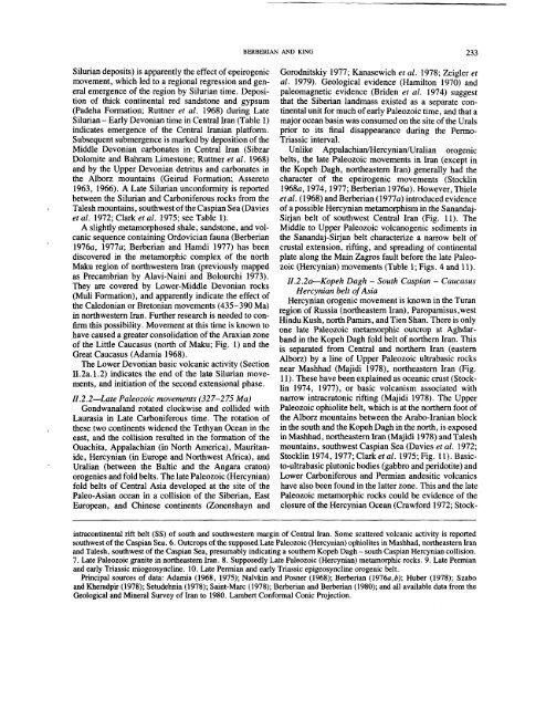
Unlike Appalachian/Hercynian/Uralian orogenic<br />
belts, the late Paleozoic movements in Iran (except in<br />
the Kopeh Dagh, northeastern Iran) generally had the<br />
character of the epeirogenic movements (Stocklin<br />
1968a, 1974, 1977; Berberian 1976a). However, Thiele<br />
et al. (1968) and Berberian (1977a) introduced evidence<br />
of a possible Hercynian metamorphism in the Sanandaj-<br />
Sirjan belt of southwest Central Iran (Fig. 11). The<br />
Middle to Upper Paleozoic volcanogenic sediments in<br />
the Sanandaj-Sirjan belt characterize a narrow belt of<br />
crustal extension, rifting, and spreading of continental<br />
plate along the Main Zagros fault before the late Paleozoic<br />
(Hercynian) movements (Table 1; Figs. 4 and 11).<br />
H.2.2a--Kopeh Dagh - South Caspian - Caucasus<br />
Hercynian belt of Asia<br />
Hercynian orogenic movement is known in the Turan<br />
region of Russia (northeastern Iran), Paropamisus,west<br />
Hindu Kush, north Pamirs, and Tien Shan. There is only<br />
one late Paleozoic metamorphic outcrop at Aghdarband<br />
in the Kopeh Dagh fold belt of northern Iran. This<br />
is separated from Central and northern Iran (eastern<br />
Alborz) by a line of Upper Paleozoic ultrabasic rocks<br />
near Mashhad (Majidi 1978), northeastern Iran (Fig.<br />
11). These have been explained as oceanic crust (Stocklin<br />
1974, 1977), or basic volcanism associated with<br />
narrow intracratonic rifting (Majidi 1978). The Upper<br />
H.2.2wLate Paleozoic movements (327-275 Ma)<br />
Gondwanaland rotated clockwise and collided with Paleozoic ophiolite belt, which is at the northern foot of<br />
Laurasia in Late Carboniferous time. The rotation of the Alborz mountains between the Arabo-Iranian block<br />
these two continents widened the Tethyan Ocean in the in the south and the Kopeh Dagh in the north, is exposed<br />
east, and the collision resulted in the formation of the in Mashhad, northeastern Iran (Majidi 1978) and Talesh<br />
Ouachita, Appalachian (in North America), Mauritanide,<br />
Hercynian (in Europe and Northwest Africa), and Stocklin 1974, 1977; Clark et al. 1975; Fig. 11). Basic-<br />
mountains, southwest Caspian Sea (Davies et al. 1972;<br />
Uralian (between the Baltic and the Angara craton) to-ultrabasic plutonic bodies (gabbro and peridotite) and<br />
orogenies and fold belts. The late Paleozoic (Hercynian) Lower Carboniferous and Permian andesitic volcanics<br />
fold belts of Central Asia developed at the site of the have also been found in the latter zone. This and the late<br />
Paleo-Asian ocean in a collision of the Siberian, East Paleozoic metamorphic rocks could be evidence of the<br />
European, and Chinese continents (Zonenshayn and closure of the Hercynian Ocean (Crawford 1972; Stockintracontinental<br />
rift belt (SS) of south and southwestern margin of Central Iran. Some scattered volcanic activity is reported<br />
southwest of the Caspian Sea. 6. Outcrops of the supposed Late Paleozoic (Hercynian) ophiolites in Mashhad, northeastern Iran<br />
and Talesh, southwest of the Caspian Sea, presumably indicating a southern Kopeh Dagh - south Caspian Hercynian collision.<br />
7. Late Paleozoic granite in northeastern Iran. 8. Supposedly Late Paleozoic (Hercynian) metamorphic rocks. 9. Late Permian<br />
and early Triassic miogeosyncline. 10. Late Permian and early Triassic epigeosyncline orogenic belt.<br />
Principal sources of data: Adamia (1968, 1975); Nalvkin and Posner (1968); Berberian (1976a,b); Huber (1978);<br />
and Kheradpir (1978); Setudehnia (1978); Saint-Marc (1978); Berberian and Berberian (1980); and all available data<br />
Geological and Mineral Survey of l.ran to 1980. Lambert Conformal Conic Projection.


