

PDF COPY - Manuel berberian
PDF COPY - Manuel berberian
PDF COPY - Manuel berberian

Create successful ePaper yourself
Turn your PDF publications into a flip-book with our unique Google optimized e-Paper software.
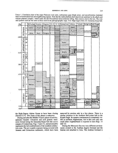
BERBERIANANDKING 215<br />
TABLE 1. Correlation chart of the major Paleozoic rock units, sedimentary gaps (blank areas), and unconformities (indented<br />
lines) in Gondwanian Iran and neighbouring regions. Note that the stable platform shelf deposits are underlain by the alkali-acid<br />
volcano-plutonic complex, which marks the late Precarnbrian’ intracontinental rifting. Data sources cited in the text. The rock<br />
unit symbols used are the same as those used on the paleogeographic maps. H-Z: High-Zagros belt; S-S: Sanandaj-Sirjan belt<br />
the High-Zagros Alpine Ocean to have been closing<br />
(Section 11.4). The cause of this phase is unknown.<br />
During and after the Middle Triassic phase of activity,<br />
andesitic-basaltic volcanism and acid granitic intrusions<br />
formed along the Sanandaj-Sirjan belt (the active<br />
margin of Central Iran; Figs. 5 and 13), and presumably<br />
represents the full establishment of the southern subduction<br />
zone. The arc is partly exposed, being covered with<br />
Jurassic and Cretaceous sediments, which have been<br />
removed by erosion only in a few places. There is a<br />
similar situation in the northern Hercynian belt in the<br />
Kopeh Dagh. Its eastern continuation is completely visible<br />
in northern Afghanistan, but in this case only one<br />
small inlier (Aghdarband) is exposed in Iran (Figs.<br />
and 12).<br />
During the Mesozoic Era two very different environments<br />
existed in the Arabian Zagros foreland and the<br />
Iranian unit attached to Asia. The Arabian foreland is


