

PDF COPY - Manuel berberian
PDF COPY - Manuel berberian
PDF COPY - Manuel berberian

Create successful ePaper yourself
Turn your PDF publications into a flip-book with our unique Google optimized e-Paper software.
subject to progressive subsidence and uniform thick<br />
shallow marine sedimentation (Table 2). There are very<br />
striking simple linear facies boundaries parallel to the<br />
old continental margin (Figs. 5 and 14). These were<br />
presumably normal faults formed during extensional<br />
movement at that time.<br />
In the north the sedimentary environment was more<br />
complex, with rapid facies changes and unstable conditions.<br />
There were large areas of shallow sea and small<br />
Red Sea type oceanic basins (the sites of the Central<br />
Iranian narrow ophiolite belts) with a few small land<br />
areas. Presumably these basins and shallow seas were<br />
associated with fragmentation of continental crust during<br />
the period of movement of the continental mass from<br />
Arabia to Asia (Figs. 4 and 5). There appears to be<br />
evidence on which to base speculation about when and<br />
how the Central Iranian narrow oceanic basins formed.<br />
However, the stratigraphic evidence suggests that the<br />
Central Iranian continental fragments were never widely<br />
separated (Tables 1, 2, and 3; Figs. 10 to 17).<br />
1.3.1--Late Cretaceous orogenic phases<br />
The Late Cretaceous Epoch in Iran is characterized by<br />
two episodes of ophiolite emplacement. The emplacement<br />
dates and the associated change of sedimentary<br />
conditions from oceanic to shallow marine are critical,<br />
since they determine the time of ocean closure. Detailed<br />
arguments outlined in Sections II.5.2b and II.5.3b constrain<br />
the dates of these changes together with the High-<br />
Zagros and the Central Iranian ophiolite emplacement to<br />
be nominally around 75 Ma and 65 Ma (Fig. 6; Table 2).<br />
The latter phase was associated with regional metamorphism,<br />
magmatism, and extensive folding and uplift<br />
throughout the country and is taken here to represent the<br />
final closure of the High-Zagros Alpine Ocean. The<br />
’High-Zagros-Oman ophiolite-radiolarite belt,’ which<br />
was emplaced in the form of a thrust stack around 75<br />
Ma, is apparently the remnant of the High-Zagros Alpine<br />
Ocean extending from southeastern Turkey via<br />
High-Zagros to Oman. The ’Central Iranian ophiolitemtlange<br />
belts’ were emplaced around 65 Ma and resulted<br />
from the subsequent closure of the ’small ocean<br />
basins’ created by fragmentation after the separation of<br />
Iran from Arabia. They form a complex system in the<br />
country (Fig. 6). The ’Makran ophiolite-mtlange’<br />
southeastern Iran (Figs. 1, 6, and 14) is not interpretable<br />
as a continental closure, since subduction of ocean crust<br />
BERBERIAN AND ~NG 217<br />
preceded and succeeded its emplacement. It may be<br />
speculated that it was associated with the collision of an<br />
island arc of the eastern High-Zagros Alpine Ocean.<br />
The Sevan-Akera and Vedi ophiolite belts of the Little<br />
Caucasus, which were emplaced around 118-105 Ma,<br />
were the remnants of the western part of the Hercynian<br />
Ocean in the northwest, and presumably were emplaced<br />
during the collision between northwestern Iran and the<br />
Caucasus (see Section 11.5. lc).<br />
The Central Iranian ophiolite-mtlange belts are associated<br />
with glaucophane-schist metamorphism (along<br />
the belt north of the Zagros fault line and in Makran),<br />
and simultaneously the active Central Iranian continental<br />
margin (the Sanandaj-Sirjan belt) was affected by<br />
greenschist metamorphic overprint (see Section<br />
II.5.3b; Figs. 6 and 14). Extensive magmatism<br />
not<br />
found associated with the closure of the internal ocean<br />
basins. This could be because the volcanism is concealed<br />
by later sediments, or because the area of ocean<br />
crust consumed was too small to allow significant volcanic<br />
arcs to become established. The second explanation<br />
is a plausible confirmation of the view that the<br />
internal ophiolites do not represent the remains of the<br />
large ocean basins.<br />
We take the Late Cretaceous events to represent the<br />
disappearance of the oceanic crust between Asia and<br />
Arabia. From this period to the present, all continued<br />
convergence of these plates apparently has been accommodated<br />
by processes that have progressively thickened<br />
and shortened the continental crust and caused its gradual<br />
emergence (Figs. 7 to 9). The compression has<br />
been accompanied by extensive volcanism and various<br />
tectonic episodes, but none have the characteristic of a<br />
closure episode and no ophiolites and pelagic sediments<br />
have been emplaced later than 55 Ma.<br />
1.4----MIDDLE AND LATE ALPIN EVENTS<br />
The Middle Alpine orogenic events started at the<br />
close of the Late Cretaceous movements (65 Ma) and<br />
ended at about 20 Ma. The Late Cretaceous movements<br />
created the main structural features of present-day Iran<br />
(Figs. 6 and 7). During the closure of the High-Zagros<br />
Alpine Ocean in the south, acid plutonic activity took<br />
place in Late Jurassic time (140 Ma) along the southern<br />
margin of Central Iran (the Sanandaj-Sirjan belt; Figs.<br />
and 14). Later plutonic activity and deformation in the<br />
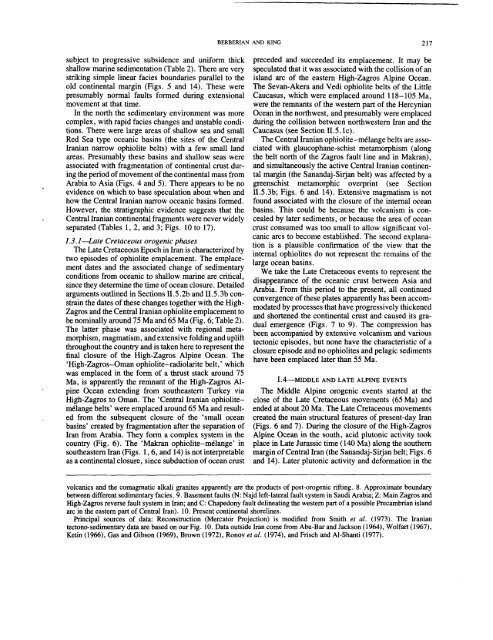
volcanics and the comagmatic alkali granites apparently are the products of post-orogenic rifting. 8. Approximate boundary<br />
between different sedimentary facies. 9. Basement faults (N: Najd left-lateral fault system in Saudi Arabia; Z: Main Zagros and<br />
High-Zagros reverse fault system in Iran; and C: Chapedony fault delineating the western part of a possible Precambrian island<br />
arc in the eastern part of Central Iran). 10. Present continental shorelines.<br />
Principal sources of data: Reconstruction (Mercat6r Projection) is modified from Smith et al. (1973). The Iranian<br />
tectono-sedimentary data are based on our Fig. 10. Data outside Iran come from Abu-Bar and Jackson (1964), Wolfart (1967),<br />
Ketin (1966), Gas and Gibson (1969), Brown (1972), et al. (1974),and Frisch and A1-Shanti (1977).


