

PDF COPY - Manuel berberian
PDF COPY - Manuel berberian
PDF COPY - Manuel berberian

Create successful ePaper yourself
Turn your PDF publications into a flip-book with our unique Google optimized e-Paper software.
was undergoing calc-alkaline magmatic activity, deformation,<br />
and simultaneous sedimentation. This is completely<br />
different from the sediments of the stable platform<br />
(of Arabia and Iran) in the south. Therefore two<br />
completely different tectonic and sedimentary regimes<br />
are represented (Fig. 10).<br />
Thus there is evidence that in this period, Iran, southeastern<br />
Turkey, Iraq, Syria, and parts of Afghanistan<br />
and Pakistan were connected (via Arabia) to Africa, and<br />
the Hercynian Ocean was to the north. This stratigraphic<br />
evidence is consistent with the paleomagnetic data (discussed<br />
in Section II).<br />
1.2.2--Late Paleozoic and Middle Triassic orogenic<br />
movements<br />
The Late Paleozoic (Hercynian) orogenic belt is presumably<br />
associated with the closure of the ’Hercynian<br />
Ocean’ (we choose to name oceans after the orogenic<br />
episode caused by their closure). The ocean was to the<br />
north of lran (as indicated by the foregoing stratigraphic<br />
evidence). It seems clear that subduction was restricted<br />
to the northern side of the ocean in the Middle East<br />
region and resulted in prolonged deformation, metamorphism,<br />
and magmatism.<br />
The deformation apparently started during Carboniferous<br />
time (about 330 Ma) and finished during the Triassic<br />
Period (about 220 Ma). Most of this deformation<br />
appears to be associated with the northward subduction<br />
and closure of the Hercynian Ocean. Towards the end of<br />
the period Iran apparently moved as one or a few continental<br />
fragments across the Hercynian Ocean, leaving<br />
new oceanic crust behind to form the ’High-Zagros<br />
Alpine Ocean’ in the south (Fig. 4). There is stratigraphic<br />
evidence (continental rift volcanism and sedimentation<br />
consistent with stretching along the Sanandaj-<br />
Sirjan belt; Fig. 11; Section II.2.2b) that Iran and<br />
BERBERIAN AND KING 213<br />
some surrounding countries were becoming detached<br />
from Arabia in Permian time (possibly around 240 Ma).<br />
However, paleomagnetic poles indicate that lran remained<br />
close to Arabia during at least the early part of<br />
this period. The Upper Triassic - Jurassic pelagic sediments<br />
along the active Central Iranian and the passive<br />
Zagros continental margins provide the first sedimentary<br />
evidence for the appearance of a true oceanic environment<br />
(Table 2).<br />
Sometime prior to the Middle Triassic orogenic phase<br />
(210 Ma), the late Paleozoic ophiolites were emplaced<br />
in the north, presumably at the time of the collision of<br />
the continental fragments with Asia (Section II.2.2a).<br />
By Middle to Late Triassic time (200 Ma) a major<br />
difference in sedimentary environment between [ran and<br />
Arabia on either side of the High-Zagros Alpine Ocean<br />
is evident. While marine carbonates continued to be<br />
1.2.l--Early Paleozoic movements (450-370 Ma)<br />
Because of the deficiency of data, no reconstruction is<br />
given for the time of the Early Paleozoic (Caledonian)<br />
movements. The deposition of Upper Silurian (395 Ma)<br />
continental sediments together with the lack of Lower<br />
deposited in a passive environment on the Arabian foreland,<br />
shallow lagoonal coal-beating detrital sediments<br />
Devonian rocks in Central Iran may indicate a Late<br />
Silurian movement (see Section II.2.1), the cause were deposited in Iran (Table 2). Furthermore, these<br />
which is not yet understood.<br />
were apparently continuous with similar deposits in<br />
southern Asia (Kopeh Dagh - Turan) suggesting that<br />
Iran and southern Asia were connected and formed a<br />
single sedimentary province by that time (Fig. 5).<br />
It is therefore concluded that the late Paleozoic - early<br />
Mesozoic phase in Iran and surrounding countries was a<br />
period when continental fragments travelled across the<br />
Hercynian Ocean to become attached to Asia (Fig. 5).<br />
The time taken does not appear to be greater than 40 Ma<br />
and, based on paleomagnetic data and our reconstructions,<br />
the continental fragments covered a distance of<br />
about 4000 km. The necessary rate of movement of I0<br />
cm/year is reasonable, since India split from Africa and<br />
formed parts of the Indian Ocean at a rate of 18 crn/year.<br />
There is some evidence of late Paleozoic low-grade<br />
metamorphism along the Sanandaj-Sirjan belt at a time<br />
when the paleomagnetic data indicate that the High-<br />
Zagros Alpine Ocean had not formed in the south (Section<br />
II.2.2b). This could be interpreted as an error in the<br />
paleomagnetic data, with some subduction occurring on<br />
the southern part of Central Iran along the Sanandaj-<br />
Sirjan belt, prior to the Middle Triassic orogenic movements.<br />
Alternatively it could be associated with the late<br />
Paleozoic closure of the rifts formed in the second Palmrlange<br />
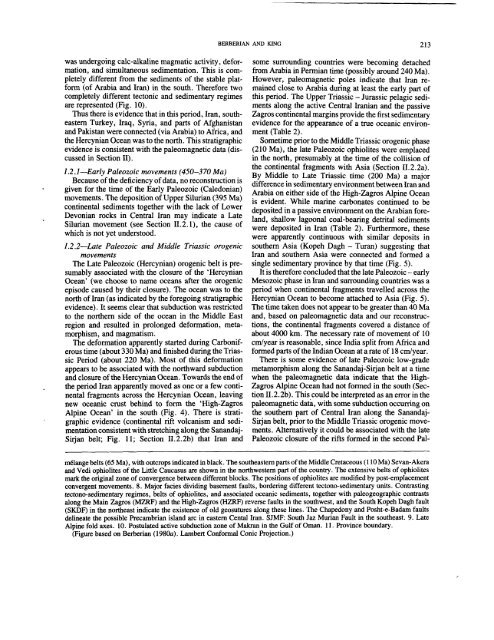
belts (65 Ma), with outcrops indicated in black. The southeastern parts of the Middle Cretaceous (110 Ma) Sevan-Akera<br />
and Vedi ophiolites of the Little Caucasus are shown in the northwestern part of the country. The extensive belts of ophiolites<br />
mark the original zone of convergence between different blocks. The positions of ophiolites are modified by post-emplacement<br />
convergent movements. 8. Major facies dividing basement faults, bordering different tectono-sedimentary units. Contrasting<br />
tectono-sedimentary regimes, belts of ophiolites, and associated oceanic sediments, together with paleogeographicontrasts<br />
along the Main Zagros (MZRF) and the High-Zagros (HZRF) reverse faults in the southwest, and the South Kopeh Dagh fault<br />
(SKDF) in the northeast indicate the existence of old geosutures along these lines. The Chapedony and Posht-e-Badam faults<br />
delineate the possible Precambrian island arc in eastern Cental Iran. SJMF: South Jaz Murian Fault in the southeast. 9. Late<br />
Alpine fold axes. 10. Postulated active subduction zone of Makran in the Gulf of Oman. 11. Province boundary.<br />
(Figure based on Berberian (1980a). Lambert Conformal Conic Projection.)


