

PDF COPY - Manuel berberian
PDF COPY - Manuel berberian
PDF COPY - Manuel berberian

You also want an ePaper? Increase the reach of your titles
YUMPU automatically turns print PDFs into web optimized ePapers that Google loves.
BERBERIAN AND KING 235<br />
OFOMAN<br />
6o o<br />
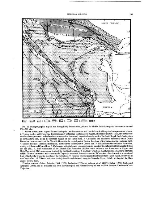
FIG. 12. Paleogeographic map of Iran during Early Triassic time, prior to the Middle Triassic orogenic movements (around<br />
230-220 Ma).<br />
1. Known mountainous regions formed during the Late Precambrian and Late Paleozoic (Hercynian) compressional phases.<br />
2. Triassic clastics and flysch-type deposits (mainly tuffaceous-carbonaceous marine, littoral fine clastics, shale, and sandstones<br />
with basal conglomerate, and subordinate stromatolitic limestone), deposited mainly north of the South Kopeh Dagh fault system<br />
in northeastern Iran, along the southern margin of the Turan plate. 3. Calcareous and tuffaceous sandstone-shale (Alam<br />
Formation, lower member of the Nakhlak Group) in the central part of Central Iran (east of the Nain ophiolite-m61ange belt).<br />
4. Shotori dolomite-limestone Formation, mostly in the eastern part of Central Iran. 5. Elikah limestone-dolomite Formation,<br />
mainly in Alborz and Central Iran. 6. Carbonates with shales and volcanics (mainly basalts with diabases) in the Sanandaj-Sirjan<br />
rift belt (SS). 7. Shelf carbonates of the Khaneh Kat Formation (shallow water dolomite and limestone) in Zagros<br />
High-Zagros belt (HZ). a: erosional limits of the Dashtak Formation. 8. Dashtak Formation, mainly restricted marine to intertidal<br />
sabkha facies of carbonates and evaporites in Zagros (b: erosional limits of evaporite "D" member of the formation, c: erosional<br />
limit of the Sefidar Dolomite member of the formation). 9. Possible Triassic quartzite in the southern Talesh region, southwest of<br />
the Caspian Sea. 10. Triassic volcanics (mainly basaltic and diabasic) along the Sanandaj-Sirjan rift belt, northeast of the Main<br />
Zagros reverse fault.<br />
Principal sources of data: Adamia (1968, 1975); Berberian (1976a,b); Adamia et al. (1977); Huber (1978); Szabo<br />
Kheradpir (1978); and all available data from the Geological and Mineral Survey of Iran to 1980. Lambert Conformal Conic<br />
Projection.


