Seismic Profiling of the Seattle Fault, Lake Sammamish ... - CGISS
Seismic Profiling of the Seattle Fault, Lake Sammamish ... - CGISS
Seismic Profiling of the Seattle Fault, Lake Sammamish ... - CGISS

Create successful ePaper yourself
Turn your PDF publications into a flip-book with our unique Google optimized e-Paper software.
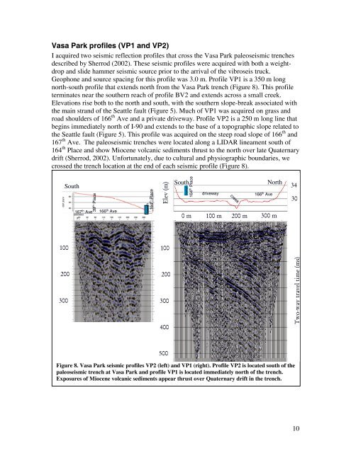
Vasa Park pr<strong>of</strong>iles (VP1 and VP2)<br />
I acquired two seismic reflection pr<strong>of</strong>iles that cross <strong>the</strong> Vasa Park paleoseismic trenches<br />
described by Sherrod (2002). These seismic pr<strong>of</strong>iles were acquired with both a weightdrop<br />
and slide hammer seismic source prior to <strong>the</strong> arrival <strong>of</strong> <strong>the</strong> vibroseis truck.<br />
Geophone and source spacing for this pr<strong>of</strong>ile was 3.0 m. Pr<strong>of</strong>ile VP1 is a 350 m long<br />
north-south pr<strong>of</strong>ile that extends north from <strong>the</strong> Vasa Park trench (Figure 8). This pr<strong>of</strong>ile<br />
terminates near <strong>the</strong> sou<strong>the</strong>rn reach <strong>of</strong> pr<strong>of</strong>ile BV2 and extends across a small creek.<br />
Elevations rise both to <strong>the</strong> north and south, with <strong>the</strong> sou<strong>the</strong>rn slope-break associated with<br />
<strong>the</strong> main strand <strong>of</strong> <strong>the</strong> <strong>Seattle</strong> fault (Figure 5). Much <strong>of</strong> VP1 was acquired on grass and<br />
road shoulders <strong>of</strong> 166 th Ave and a private driveway. Pr<strong>of</strong>ile VP2 is a 250 m long line that<br />
begins immediately north <strong>of</strong> I-90 and extends to <strong>the</strong> base <strong>of</strong> a topographic slope related to<br />
<strong>the</strong> <strong>Seattle</strong> fault (Figure 5). This pr<strong>of</strong>ile was acquired on <strong>the</strong> steep road slope <strong>of</strong> 166 th and<br />
167 th Ave. The paleoseismic trenches were located along a LIDAR lineament south <strong>of</strong><br />
164 th Place and show Miocene volcanic sediments thrust to <strong>the</strong> north over late Quaternary<br />
drift (Sherrod, 2002). Unfortunately, due to cultural and physiographic boundaries, we<br />
crossed <strong>the</strong> trench location at <strong>the</strong> end <strong>of</strong> each seismic pr<strong>of</strong>ile (Figure 8).<br />
South<br />
39 th Place<br />
167 th Ave 166 th Ave<br />
164 th Place<br />
trench<br />
N<br />
Elev (m)<br />
trench<br />
164 th Place<br />
South<br />
driveway<br />
creek<br />
166 th Ave<br />
North<br />
0 m 100 m 200 m 300 m<br />
34<br />
30<br />
100<br />
100<br />
200<br />
300<br />
200<br />
300<br />
400<br />
Two-way travel time (ms)<br />
500<br />
Figure 8. Vasa Park seismic pr<strong>of</strong>iles VP2 (left) and VP1 (right). Pr<strong>of</strong>ile VP2 is located south <strong>of</strong> <strong>the</strong><br />
paleoseismic trench at Vasa Park and pr<strong>of</strong>ile VP1 is located immediately north <strong>of</strong> <strong>the</strong> trench.<br />
Exposures <strong>of</strong> Miocene volcanic sediments appear thrust over Quaternary drift in <strong>the</strong> trench.<br />
10