Seismic Profiling of the Seattle Fault, Lake Sammamish ... - CGISS
Seismic Profiling of the Seattle Fault, Lake Sammamish ... - CGISS
Seismic Profiling of the Seattle Fault, Lake Sammamish ... - CGISS

Create successful ePaper yourself
Turn your PDF publications into a flip-book with our unique Google optimized e-Paper software.
Geologic and Tectonic Setting<br />
The broad valley west <strong>of</strong> <strong>the</strong> Cascade Range and east <strong>of</strong> <strong>the</strong> Olympic Mountains in <strong>the</strong><br />
vicinity <strong>of</strong> <strong>Seattle</strong>, Washington, is termed <strong>the</strong> Puget Lowland. This forearc basin lies<br />
above terranes accreted to North America along <strong>the</strong> Cascadia subduction zone. Oblique<br />
convergence along <strong>the</strong> continental margin (Wells et al., 1998) is accommodated by northsouth<br />
shortening in <strong>the</strong> Puget Lowland (Miller et al., 2001). The <strong>Seattle</strong> fault is a northdirected<br />
thrust fault separating <strong>the</strong> <strong>Seattle</strong> basin on <strong>the</strong> north, from <strong>the</strong> <strong>Seattle</strong> uplift and<br />
Tacoma Basin to its south (e.g., Pratt et al., 1997). The surface expression <strong>of</strong> <strong>the</strong> <strong>Seattle</strong><br />
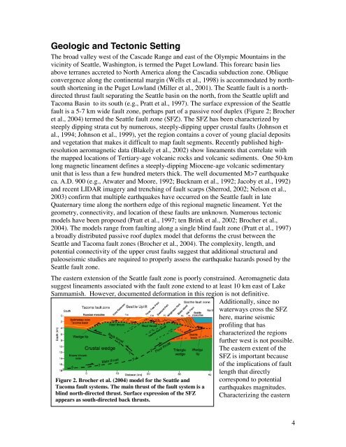
fault is a 5-7 km wide fault zone, perhaps part <strong>of</strong> a passive ro<strong>of</strong> duplex (Figure 2; Brocher<br />
et al., 2004) termed <strong>the</strong> <strong>Seattle</strong> fault zone (SFZ). The SFZ has been characterized by<br />
steeply dipping strata cut by numerous, steeply-dipping upper crustal faults (Johnson et<br />
al., 1994; Johnson et al., 1999), yet <strong>the</strong> region contains a cover <strong>of</strong> young glacial deposits<br />
and vegetation that makes it difficult to map fault segments. Recently published highresolution<br />
aeromagnetic data (Blakely et al., 2002) show lineaments that correlate with<br />
<strong>the</strong> mapped locations <strong>of</strong> Tertiary-age volcanic rocks and volcanic sediments. One 50-km<br />
long magnetic lineament defines a steeply-dipping Miocene-age volcanic sedimentary<br />
unit that is less than a few hundred meters thick. The well documented M>7 earthquake<br />
ca. A.D. 900 (e.g., Atwater and Moore, 1992; Bucknam et al., 1992; Jacoby et al., 1992)<br />
and recent LIDAR imagery and trenching <strong>of</strong> fault scarps (Sherrod, 2002; Nelson et al.,<br />
2003) confirm that multiple earthquakes have occurred on <strong>the</strong> <strong>Seattle</strong> fault in late<br />
Quaternary time along <strong>the</strong> nor<strong>the</strong>rn edge <strong>of</strong> this regional magnetic lineament. Yet <strong>the</strong><br />
geometry, connectivity, and location <strong>of</strong> <strong>the</strong>se faults are unknown. Numerous tectonic<br />
models have been proposed (Pratt et al., 1997; ten Brink et al., 2002; Brocher et al.,<br />
2004). The models range from faulting along a single blind fault zone (Pratt et al., 1997)<br />
a broadly distributed passive ro<strong>of</strong> duplex model that deforms <strong>the</strong> crust between <strong>the</strong><br />
<strong>Seattle</strong> and Tacoma fault zones (Brocher et al., 2004). The complexity, length, and<br />
potential connectivity <strong>of</strong> <strong>the</strong> upper crust faults suggest that additional structural and<br />
paleoseismic studies are required to properly assess <strong>the</strong> earthquake hazards posed by <strong>the</strong><br />
<strong>Seattle</strong> fault zone.<br />
The eastern extension <strong>of</strong> <strong>the</strong> <strong>Seattle</strong> fault zone is poorly constrained. Aeromagnetic data<br />
suggest lineaments associated with <strong>the</strong> fault zone extend to at least 10 km east <strong>of</strong> <strong>Lake</strong><br />
<strong>Sammamish</strong>. However, documented deformation in this region is not definitive.<br />
Additionally, since no<br />
waterways cross <strong>the</strong> SFZ<br />
here, marine seismic<br />
pr<strong>of</strong>iling that has<br />
characterized <strong>the</strong> regions<br />
fur<strong>the</strong>r west is not possible.<br />
The eastern extent <strong>of</strong> <strong>the</strong><br />
SFZ is important because<br />
<strong>of</strong> <strong>the</strong> implications <strong>of</strong> fault<br />
Figure 2. Brocher et al. (2004) model for <strong>the</strong> <strong>Seattle</strong> and<br />
Tacoma fault systems. The main thrust <strong>of</strong> <strong>the</strong> fault system is a<br />
blind north-directed thrust. Surface expression <strong>of</strong> <strong>the</strong> SFZ<br />
appears as south-directed back thrusts.<br />
length that directly<br />
correspond to potential<br />
earthquakes magnitudes.<br />
Characterizing <strong>the</strong> eastern<br />
4