Seismic Profiling of the Seattle Fault, Lake Sammamish ... - CGISS
Seismic Profiling of the Seattle Fault, Lake Sammamish ... - CGISS
Seismic Profiling of the Seattle Fault, Lake Sammamish ... - CGISS

Create successful ePaper yourself
Turn your PDF publications into a flip-book with our unique Google optimized e-Paper software.
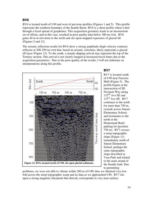
BV6<br />
BV6 is located north <strong>of</strong> I-90 and west <strong>of</strong> previous pr<strong>of</strong>iles (Figures 1 and 5). This pr<strong>of</strong>ile<br />
represents <strong>the</strong> sou<strong>the</strong>rn boundary <strong>of</strong> <strong>the</strong> <strong>Seattle</strong> Basin. BV6 is a short pr<strong>of</strong>ile where I shot<br />
through a fixed spread <strong>of</strong> geophones. This acquisition geometry leads to an inconsistent<br />
set <strong>of</strong> <strong>of</strong>fsets, and in this case, resulted in poor quality data below 300 ms twtt. BV6<br />
gains 40 m in elevation to <strong>the</strong> north and sits upon mapped exposures <strong>of</strong> glacial till<br />
(Figures 5 and 12).<br />
The seismic reflection results for BV6 show a strong amplitude (high-velocity contrast)<br />
reflector at 200-250 ms twtt that, based on seismic velocities, likely represents a glacial<br />
till layer (Figure 12). To <strong>the</strong> south, a steeply dipping arrival may represent <strong>the</strong> top <strong>of</strong> <strong>the</strong><br />
Tertiary section. This arrival is not clearly imaged at increased travel times due to <strong>the</strong><br />
acquisition parameters. Due to <strong>the</strong> poor quality <strong>of</strong> <strong>the</strong> results, I will not elaborate on<br />
interpretations along this pr<strong>of</strong>ile.<br />
BV7<br />
BV7 is located south<br />
<strong>of</strong> I-90 near Factoria<br />
South<br />
North<br />
60<br />
Mall (Figure 5). The<br />
pr<strong>of</strong>ile begins at <strong>the</strong><br />
40 intersection <strong>of</strong> SE<br />
150 m 350 m 550 m 750 m<br />
Newport Way along<br />
132 nd Ave SE and<br />
133 rd Ave SE. BV7<br />
100<br />
continues to <strong>the</strong> north<br />
for more than 750 m,<br />
extends across Sunset<br />
Elementary School,<br />
300<br />
and terminates to <strong>the</strong><br />
north in <strong>the</strong><br />
Homestead Hotel<br />
parking lot (position<br />
500<br />
750 m). BV7 crosses<br />
a steep topographic<br />
slope (Figure 13)<br />
immediately north <strong>of</strong><br />
700<br />
Sunset Elementary<br />
School, perhaps <strong>the</strong><br />
same topographic<br />
slope described at<br />
900<br />
Vasa Park and related<br />
to <strong>the</strong> main strand <strong>of</strong><br />
Figure 12. BV6, located north <strong>of</strong> I-90, sits upon glacial sediments.<br />
<strong>the</strong> <strong>Seattle</strong> fault. Due<br />
to permitting<br />
problems, we were not able to vibrate within 200 m <strong>of</strong> I-90, thus we obtained very low<br />
fold across <strong>the</strong> steep topographic scarp and no data as we approached I-90. BV7 sits<br />
upon a strong magnetic lineament that directly corresponds to very near-surface<br />
Elev (m)<br />
Two-way travel time (ms)<br />
14