Seismic Profiling of the Seattle Fault, Lake Sammamish ... - CGISS
Seismic Profiling of the Seattle Fault, Lake Sammamish ... - CGISS
Seismic Profiling of the Seattle Fault, Lake Sammamish ... - CGISS

You also want an ePaper? Increase the reach of your titles
YUMPU automatically turns print PDFs into web optimized ePapers that Google loves.
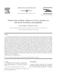
3600<br />
2800 Aeromagnetic Map<br />
0<br />
Elev (m)<br />
200<br />
400<br />
600<br />
800<br />
1000<br />
South<br />
150 80<br />
North<br />
130<br />
3000 m 2400 m 1800 m 1200 m 600 m 0 m<br />
1200<br />
Figure 17. SM1 with elevation pr<strong>of</strong>ile. Above lies <strong>the</strong> aeromagnetic map for a swath that parallels<br />
SM1. Note that near position 3500 m, a strong magnetic lineament appears that correlates with<br />
Miocene-age volcanic sediments.<br />
Two-way travel time (ms)<br />
N<br />
Two-way travel time (ms)<br />
Elev (m)<br />
S<br />
South<br />
North<br />
160<br />
140<br />
120<br />
3500 m 3000 m<br />
2500 m 2000 m 1600 m<br />
200<br />
400<br />
600<br />
800<br />
Two-way travel time (ms)<br />
1000<br />
Figure 18. The sou<strong>the</strong>rn portions <strong>of</strong> SM1 highlighting <strong>the</strong> deformation front associated with <strong>the</strong> SFZ.<br />
SM2<br />
Because SM1 did not extend south <strong>of</strong> <strong>the</strong> King County boundary, I acquired pr<strong>of</strong>ile SM2.<br />
Pr<strong>of</strong>ile SM2 is located south and west <strong>of</strong> SM1 on 219 th Place SE in <strong>Sammamish</strong> (Figure<br />
1). Elevations along this pr<strong>of</strong>ile range from 120-135 m above sea level. Although <strong>the</strong><br />
19