Seismic Profiling of the Seattle Fault, Lake Sammamish ... - CGISS
Seismic Profiling of the Seattle Fault, Lake Sammamish ... - CGISS
Seismic Profiling of the Seattle Fault, Lake Sammamish ... - CGISS

You also want an ePaper? Increase the reach of your titles
YUMPU automatically turns print PDFs into web optimized ePapers that Google loves.
marine sediments along a relatively steep glacially-scoured topography (Figures 5 and 9).<br />
The seismic reflection data show a package <strong>of</strong> reflections in <strong>the</strong> upper 300 m that appear<br />
as a broad fold whose axis is located at approximately 400 m distance (Figure 9). The<br />
lack <strong>of</strong> obvious reflector <strong>of</strong>fsets suggests that this section is not faulted, but likely<br />
deformed by north-south shortening.<br />
BV4<br />
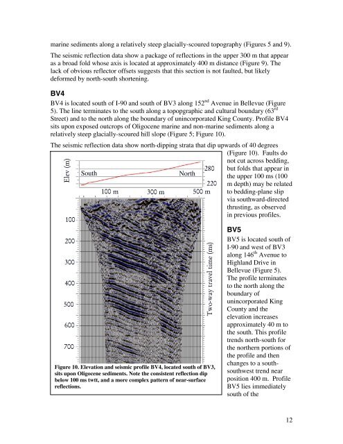
BV4 is located south <strong>of</strong> I-90 and south <strong>of</strong> BV3 along 152 nd Avenue in Bellevue (Figure<br />
5). The line terminates to <strong>the</strong> south along a topopgraphic and cultural boundary (63 rd<br />
Street) and to <strong>the</strong> north along <strong>the</strong> boundary <strong>of</strong> unincorporated King County. Pr<strong>of</strong>ile BV4<br />
sits upon exposed outcrops <strong>of</strong> Oligocene marine and non-marine sediments along a<br />
relatively steep glacially-scoured hill slope (Figure 5; Figure 10).<br />
The seismic reflection data show north-dipping strata that dip upwards <strong>of</strong> 40 degrees<br />
(Figure 10). <strong>Fault</strong>s do<br />
Elev (m)<br />
100<br />
200<br />
300<br />
400<br />
500<br />
600<br />
700<br />
South<br />
North<br />
280<br />
220<br />
100 m 300 m 500 m<br />
Two-way travel time (ms)<br />
Figure 10. Elevation and seismic pr<strong>of</strong>ile BV4, located south <strong>of</strong> BV3,<br />
sits upon Oligocene sediments. Note <strong>the</strong> consistent reflection dip<br />
below 100 ms twtt, and a more complex pattern <strong>of</strong> near-surface<br />
reflections.<br />
not cut across bedding,<br />
but folds that appear in<br />
<strong>the</strong> upper 100 ms (100<br />
m depth) may be related<br />
to bedding-plane slip<br />
via southward-directed<br />
thrusting, as observed<br />
in previous pr<strong>of</strong>iles.<br />
BV5<br />
BV5 is located south <strong>of</strong><br />
I-90 and west <strong>of</strong> BV3<br />
along 146 th Avenue to<br />
Highland Drive in<br />
Bellevue (Figure 5).<br />
The pr<strong>of</strong>ile terminates<br />
to <strong>the</strong> north along <strong>the</strong><br />
boundary <strong>of</strong><br />
unincorporated King<br />
County and <strong>the</strong><br />
elevation increases<br />
approximately 40 m to<br />
<strong>the</strong> south. This pr<strong>of</strong>ile<br />
trends north-south for<br />
<strong>the</strong> nor<strong>the</strong>rn portions <strong>of</strong><br />
<strong>the</strong> pr<strong>of</strong>ile and <strong>the</strong>n<br />
changes to a southsouthwest<br />
trend near<br />
position 400 m. Pr<strong>of</strong>ile<br />
BV5 lies immediately<br />
south <strong>of</strong> <strong>the</strong><br />
12