Seismic Profiling of the Seattle Fault, Lake Sammamish ... - CGISS
Seismic Profiling of the Seattle Fault, Lake Sammamish ... - CGISS
Seismic Profiling of the Seattle Fault, Lake Sammamish ... - CGISS

Create successful ePaper yourself
Turn your PDF publications into a flip-book with our unique Google optimized e-Paper software.
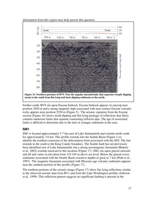
information from this region may help answer this question.<br />
Elev (m)<br />
South<br />
1300 m<br />
North<br />
1100 m 900 m 700 m 500 m 300 m<br />
160<br />
130<br />
100<br />
100<br />
200<br />
300<br />
400<br />
500<br />
600<br />
Two-way travel time (ms)<br />
700<br />
800<br />
Figure 15. Nor<strong>the</strong>rn portions <strong>of</strong> BV9. Note <strong>the</strong> angular unconformity that separates steeply dipping<br />
strata to <strong>the</strong> south from flat lying and back dipping sediments to <strong>the</strong> north.<br />
Fur<strong>the</strong>r south, BV9 sits upon Eocene bedrock. Eocene bedrock appears in outcrop near<br />
position 2850 m and a strong magnetic high associated with near-surface Eocene volcanic<br />
rocks appears near position 2250 m (Figure 5). The seismic signature from <strong>the</strong> Eocene<br />
section (Figure 16) shows north-dipping and flat-lying package <strong>of</strong> reflections that likely<br />
contains numerous faults that separate contrasting reflector dips. The age <strong>of</strong> associated<br />
faults is difficult to determine due to <strong>the</strong> lack <strong>of</strong> younger sediments in <strong>the</strong> area.<br />
SM1<br />
SM1 is located approximately 5-7 km east <strong>of</strong> <strong>Lake</strong> <strong>Sammamish</strong> and extends north-south<br />
for approximately 3.6 km. This pr<strong>of</strong>ile extends into <strong>the</strong> <strong>Seattle</strong> Basin (Figure 1) to<br />
identify <strong>the</strong> nor<strong>the</strong>rn extension <strong>of</strong> <strong>the</strong> deformation front associated with <strong>the</strong> SFZ. The line<br />
extends to <strong>the</strong> south to <strong>the</strong> King County boundary. The <strong>Seattle</strong> fault has not previously<br />
been identified east <strong>of</strong> <strong>Lake</strong> <strong>Sammamish</strong>, but a strong aeromagnetic lineament (Blakely<br />
et al., 2002) extends eastward to this location (Figure 17). SM1 sits upon glacial outwash<br />
and till and varies in elevation from 125-165 m above sea level. Below <strong>the</strong> glacial cover,<br />
sediments associated with <strong>the</strong> <strong>Seattle</strong> Basin extend to depths as great as 7 km (Pratt et al.,<br />
1997). The magnetic lineament associated with Miocene-age volcanic sediments appears<br />
near <strong>the</strong> sou<strong>the</strong>rn portion <strong>of</strong> this pr<strong>of</strong>ile (Figure 17).<br />
The nor<strong>the</strong>rn portions <strong>of</strong> <strong>the</strong> seismic image (Figure 17) show flat-lying reflections similar<br />
to <strong>the</strong> observed seismic data from BV1 and from <strong>the</strong> <strong>Lake</strong> Washington pr<strong>of</strong>iles (Johnson<br />
et al., 1999). This reflection pattern suggests no significant faulting is present in <strong>the</strong><br />
17