Seismic Profiling of the Seattle Fault, Lake Sammamish ... - CGISS
Seismic Profiling of the Seattle Fault, Lake Sammamish ... - CGISS
Seismic Profiling of the Seattle Fault, Lake Sammamish ... - CGISS

You also want an ePaper? Increase the reach of your titles
YUMPU automatically turns print PDFs into web optimized ePapers that Google loves.
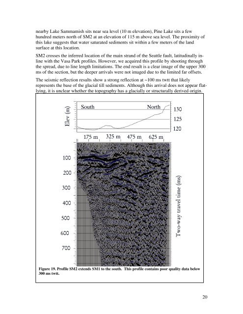
nearby <strong>Lake</strong> <strong>Sammamish</strong> sits near sea level (10 m elevation), Pine <strong>Lake</strong> sits a few<br />
hundred meters north <strong>of</strong> SM2 at an elevation <strong>of</strong> 115 m above sea level. The proximity <strong>of</strong><br />
this lake suggests that water saturated sediments sit within a few meters <strong>of</strong> <strong>the</strong> land<br />
surface at this location.<br />
SM2 crosses <strong>the</strong> inferred location <strong>of</strong> <strong>the</strong> main strand <strong>of</strong> <strong>the</strong> <strong>Seattle</strong> fault, latitudinally inline<br />
with <strong>the</strong> Vasa Park pr<strong>of</strong>iles. However, we acquired this pr<strong>of</strong>ile by shooting through<br />
<strong>the</strong> spread, due to line length limitations. The end result is a clear image <strong>of</strong> <strong>the</strong> upper 300<br />
ms <strong>of</strong> <strong>the</strong> section, but <strong>the</strong> deeper arrivals were not imaged due to <strong>the</strong> limited far <strong>of</strong>fsets.<br />
The seismic reflection results show a strong reflection at ~100 ms twtt that likely<br />
represents <strong>the</strong> base <strong>of</strong> <strong>the</strong> glacial till sediments. Although this arrival does not appear flatlying,<br />
it is unclear whe<strong>the</strong>r <strong>the</strong> topography has a glacially or structurally derived origin.<br />
Elev (m)<br />
South<br />
175 m<br />
325 m 475 m<br />
North<br />
625 m<br />
130<br />
125<br />
120<br />
100<br />
200<br />
300<br />
400<br />
500<br />
600<br />
Two-way travel time (ms)<br />
700<br />
Figure 19. Pr<strong>of</strong>ile SM2 extends SM1 to <strong>the</strong> south. This pr<strong>of</strong>ile contains poor quality data below<br />
300 ms twtt.<br />
20