Seismic Profiling of the Seattle Fault, Lake Sammamish ... - CGISS
Seismic Profiling of the Seattle Fault, Lake Sammamish ... - CGISS
Seismic Profiling of the Seattle Fault, Lake Sammamish ... - CGISS

You also want an ePaper? Increase the reach of your titles
YUMPU automatically turns print PDFs into web optimized ePapers that Google loves.
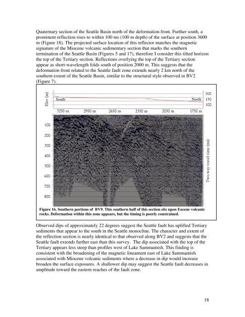
Quaternary section <strong>of</strong> <strong>the</strong> <strong>Seattle</strong> Basin north <strong>of</strong> <strong>the</strong> deformation front. Fur<strong>the</strong>r south, a<br />
prominent reflection rises to within 100 ms (100 m depth) <strong>of</strong> <strong>the</strong> surface at position 3600<br />
m (Figure 18). The projected surface location <strong>of</strong> this reflector matches <strong>the</strong> magnetic<br />
signature <strong>of</strong> <strong>the</strong> Miocene volcanic sedimentary section that marks <strong>the</strong> sou<strong>the</strong>rn<br />
termination <strong>of</strong> <strong>the</strong> <strong>Seattle</strong> Basin (Figures 5 and 17), <strong>the</strong>refore I consider this tilted horizon<br />
<strong>the</strong> top <strong>of</strong> <strong>the</strong> Tertiary section. Reflections overlying <strong>the</strong> top <strong>of</strong> <strong>the</strong> Tertiary section<br />
appear as short-wavelength folds south <strong>of</strong> position 2000 m. This suggests that <strong>the</strong><br />
deformation front related to <strong>the</strong> <strong>Seattle</strong> fault zone extends nearly 2 km north <strong>of</strong> <strong>the</strong><br />
sou<strong>the</strong>rn extent <strong>of</strong> <strong>the</strong> <strong>Seattle</strong> Basin, similar to <strong>the</strong> structural style observed in BV2<br />
(Figure 7).<br />
Elev (m)<br />
South<br />
3250 m<br />
North<br />
2950 m 2650 m 2350 m 2050 m 1750 m<br />
160<br />
130<br />
100<br />
100<br />
200<br />
300<br />
400<br />
500<br />
600<br />
Two-way travel time (ms)<br />
700<br />
800<br />
Figure 16. Sou<strong>the</strong>rn portions <strong>of</strong> BV9. This sou<strong>the</strong>rn half <strong>of</strong> this section sits upon Eocene volcanic<br />
rocks. Deformation within this zone appears, but <strong>the</strong> timing is poorly constrained.<br />
Observed dips <strong>of</strong> approximately 22 degrees suggest <strong>the</strong> <strong>Seattle</strong> fault has uplifted Tertiary<br />
sediments that appear to <strong>the</strong> south in <strong>the</strong> <strong>Seattle</strong> monocline. The character and extent <strong>of</strong><br />
<strong>the</strong> reflection section is nearly identical to that observed along BV2 and suggests that <strong>the</strong><br />
<strong>Seattle</strong> fault extends fur<strong>the</strong>r east than this survey. The dip associated with <strong>the</strong> top <strong>of</strong> <strong>the</strong><br />
Tertiary appears less steep than pr<strong>of</strong>iles west <strong>of</strong> <strong>Lake</strong> <strong>Sammamish</strong>. This finding is<br />
consistent with <strong>the</strong> broadening <strong>of</strong> <strong>the</strong> magnetic lineament east <strong>of</strong> <strong>Lake</strong> <strong>Sammamish</strong><br />
associated with Miocene volcanic sediments where a decrease in dip would increase<br />
broaden <strong>the</strong> surface exposures. A shallower dip may suggest <strong>the</strong> <strong>Seattle</strong> fault decreases in<br />
amplitude toward <strong>the</strong> eastern reaches <strong>of</strong> <strong>the</strong> fault zone.<br />
18