Farming in the - WordPress.com
Farming in the - WordPress.com
Farming in the - WordPress.com

Create successful ePaper yourself
Turn your PDF publications into a flip-book with our unique Google optimized e-Paper software.
Analysis of <strong>the</strong> agricultural situation <strong>in</strong> Azraq Bas<strong>in</strong><br />
German-Jordanian Programme “Management of Water Resources”<br />
I – Azraq Bas<strong>in</strong>: heterogeneity<br />
of <strong>the</strong> physical, hydrological<br />
and human characteristics<br />
1.1. General Presentation of<br />
Azraq Bas<strong>in</strong><br />
Azraq bas<strong>in</strong> covers an area of<br />
about 12700 km 2 (15% of Jordan<br />
superficies) 5 . Azraq bas<strong>in</strong> is a<br />
desert, mostly flat to hilly area<br />
east of <strong>the</strong> Highlands. “Highlands”<br />
is used <strong>in</strong> this study to describe <strong>the</strong><br />
agriculture part of Jordan located<br />
on <strong>the</strong> Eastern Plateau, as opposed<br />
to <strong>the</strong> Jordan Valley. The lowest<br />
po<strong>in</strong>t of <strong>the</strong> bas<strong>in</strong> is located at<br />
<strong>the</strong> Azraq depression (Qa’a) with<br />
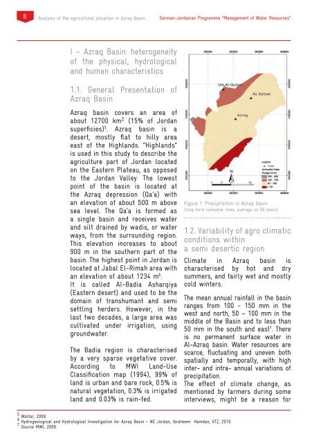
an elevation of about 500 m above Figure 1: Precipitation <strong>in</strong> Azraq bas<strong>in</strong><br />
sea level. The Qa’a is formed as<br />
(long term Isohyetal l<strong>in</strong>es, average on 50 years)<br />
a s<strong>in</strong>gle bas<strong>in</strong> and receives water<br />
and silt dra<strong>in</strong>ed by wadis, or water<br />
1.2. Variability of agro climatic<br />
ways, from <strong>the</strong> surround<strong>in</strong>g region.<br />
This elevation <strong>in</strong>creases to about conditions with<strong>in</strong><br />
900 m <strong>in</strong> <strong>the</strong> sou<strong>the</strong>rn part of <strong>the</strong> a semi desertic region<br />
bas<strong>in</strong>. The highest po<strong>in</strong>t <strong>in</strong> Jordan is Climate <strong>in</strong> Azraq bas<strong>in</strong> is<br />
located at Jabal El-Rimah area with characterised by hot and dry<br />
an elevation of about 1234 m 6 . summers, and fairly wet and mostly<br />
It is called Al-Badia Asharqiya cold w<strong>in</strong>ters.<br />
(Eastern desert) and used to be <strong>the</strong><br />
doma<strong>in</strong> of transhumant and semi<br />
The mean annual ra<strong>in</strong>fall <strong>in</strong> <strong>the</strong> bas<strong>in</strong><br />
settl<strong>in</strong>g herders. However, <strong>in</strong> <strong>the</strong><br />
ranges from 100 - 150 mm <strong>in</strong> <strong>the</strong><br />
west and north, 50 – 100 mm <strong>in</strong> <strong>the</strong><br />
last two decades, a large area was<br />
middle of <strong>the</strong> Bas<strong>in</strong> and to less than<br />
cultivated under irrigation, us<strong>in</strong>g<br />
50 mm <strong>in</strong> <strong>the</strong> south and east<br />
groundwater.<br />
7 . There<br />
is no permanent surface water <strong>in</strong><br />
Al-Azraq bas<strong>in</strong>. Water resources are<br />
The Badia region is characterised scarce, fluctuat<strong>in</strong>g and uneven both<br />
by a very sparse vegetative cover. spatially and temporally, with high<br />
Accord<strong>in</strong>g to MWI Land-Use <strong>in</strong>ter- and <strong>in</strong>tra- annual variations of<br />
Classification map (1994), 99% of precipitation.<br />
land is urban and bare rock, 0.5% is The effect of climate change, as<br />
natural vegetation, 0.3% is irrigated mentioned by farmers dur<strong>in</strong>g some<br />
land and 0.03% is ra<strong>in</strong>-fed. <strong>in</strong>terviews, might be a reason for<br />
5 Wolter, 2009.<br />
6 Hydrogeological and Hydrological Investigation for Azraq Bas<strong>in</strong> – NE Jordan, Ibraheem Hamdan, GTZ, 2010.<br />
7 Source MWI, 2009.