Farming in the - WordPress.com
Farming in the - WordPress.com
Farming in the - WordPress.com

Create successful ePaper yourself
Turn your PDF publications into a flip-book with our unique Google optimized e-Paper software.
Analysis of <strong>the</strong> agricultural situation <strong>in</strong> Azraq Bas<strong>in</strong><br />
German-Jordanian Programme “Management of Water Resources”<br />
<br />
<strong>the</strong> decrease of ra<strong>in</strong>fall <strong>in</strong> <strong>the</strong> last<br />
5 years. Over <strong>the</strong> whole region,<br />
irrigation is needed for agriculture.<br />
Most of <strong>the</strong> soil <strong>in</strong> <strong>the</strong> bas<strong>in</strong> is<br />
characterised as arid soil, with<br />
a high soluble salt content <strong>in</strong><br />
<strong>the</strong> subsurface horizons 8 . The<br />
predom<strong>in</strong>ant soil type is Silty Clay<br />
Loam. In Azraq region (East Jordan<br />
Limestone Plateau), soil is mostly<br />
poor and ei<strong>the</strong>r clay, Hammada,<br />
sal<strong>in</strong>e or calcareous. Soils are<br />
primarily <strong>com</strong>posed of limestone<br />
with fl<strong>in</strong>t scattered all over, or<br />
covered by basalt pebbles and<br />
boulders that resulted from volcanic<br />
out cross<strong>in</strong>g centred on Jabal Druze.<br />
In <strong>the</strong> middle of <strong>the</strong> Badia and to<br />
<strong>the</strong> south of Azraq, soils be<strong>com</strong>e<br />
sal<strong>in</strong>e and conta<strong>in</strong> gypsum 9 .<br />
In <strong>the</strong> North Jordan basalt Plateau,<br />
basaltic lava plateau from Jabal<br />
Druze soil is developed on parent<br />
lava rock and Aeolian silt is<br />
likely to have participated <strong>in</strong><br />
soil formation . Soils are deep to<br />
moderately deep, slightly gravely,<br />
with a f<strong>in</strong>e silty loam texture <strong>in</strong> <strong>the</strong><br />
surface, and subsoil horizons rich<br />
<strong>in</strong> CaCO3. The high silt content of<br />
<strong>the</strong> Surface surface irrigation soil, and <strong>the</strong> absence<br />
of Open suitable tube organic content makes<br />
soils Virojethighly susceptible to gully<br />
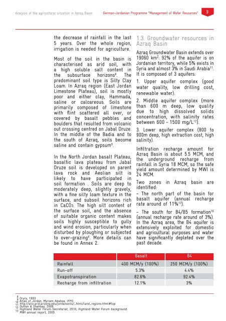
1.3. Groundwater resources <strong>in</strong><br />
Azraq Bas<strong>in</strong><br />
Azraq Groundwater Bas<strong>in</strong> extends over<br />
19060 km 2 : 92% of <strong>the</strong> aquifer is on<br />
Jordanian territory, while 5% exists <strong>in</strong><br />
Syria and almost 3% <strong>in</strong> Saudi Arabia 11 .<br />
It is <strong>com</strong>posed of 3 aquifers:<br />
1. Upper aquifer <strong>com</strong>plex (good<br />
water quality, low drill<strong>in</strong>g cost,<br />
renewable water).<br />
2. Middle aquifer <strong>com</strong>plex (more<br />
than 600 m deep, low quality<br />
due to high dissolved solids<br />
concentration, with sal<strong>in</strong>ity rates<br />
between 600 – 1500 mg/L 12 ).<br />
3. Lower aquifer <strong>com</strong>plex (800 to<br />
900m deep, high extraction cost, high<br />
sal<strong>in</strong>ity).<br />
Infiltration recharge amount for<br />
Azraq Bas<strong>in</strong> is about 5.5 MCM, and<br />
<strong>the</strong> underground recharge from<br />
ra<strong>in</strong>fall <strong>in</strong> Syria 18 MCM, so <strong>the</strong> safe<br />
yield amount determ<strong>in</strong>ed by MWI is<br />
24 MCM.<br />
Two zones <strong>in</strong> Azraq bas<strong>in</strong> are<br />
identified:<br />
- The north part of <strong>the</strong> bas<strong>in</strong> for<br />
basalt aquifer (annual recharge<br />
Efficiency current rate system around Efficiency of 11% 13 optimised ). system<br />
55% - The south for B4/B5 - formation 10<br />
65% (annual recharge rate 70% around of 3%).<br />
60% In <strong>the</strong> Azraq area, <strong>the</strong> 85% B4 aquifer is<br />
and w<strong>in</strong>d erosion, particularly when extensively exploited for domestic<br />
disturbed<br />
Dripper (GR)<br />
by plough<strong>in</strong>g or subjected<br />
70%<br />
90%<br />
and agricultural purposes and water<br />
to over-graz<strong>in</strong>g 6 . More details can have significantly depleted over <strong>the</strong><br />
be found <strong>in</strong> Annex 2.<br />
past decade.<br />
Ra<strong>in</strong>fall<br />
Run-off<br />
Evapotranspiration<br />
Recharge from <strong>in</strong>filtration<br />
Basalt<br />
400 MCM/y (100%)<br />
5.3%<br />
82.6%<br />
12.1%<br />
B4<br />
250 MCM/y (100%)<br />
4.4%<br />
92.4%<br />
3%<br />
8<br />
9 Drury, 1993.<br />
10 Atlas of Jordan, Myriam Ababsa, IFPO.<br />
11 http://alic.arid.arizona.edu/jordansoils/_html/land_regions.html#top<br />
Dutton & Shahbaz, 2009.<br />
Ra<strong>in</strong>fall<br />
Azraq<br />
12 Highland Water Forum Secretariat, 2010, Highland Water Forum background.<br />
13 MWI annual report, 2009.<br />
Less than 100 mm<br />
Desert climate (hot<br />
North Badia<br />
Jiza<br />
100 – 150 mm 100 – 150 mm