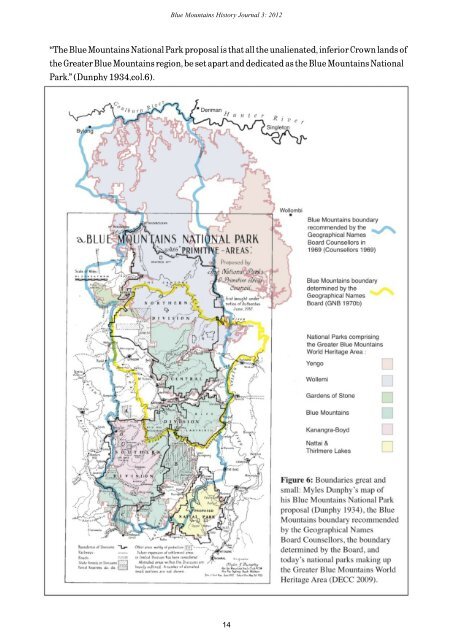
<strong>Blue</strong> <strong>Mountains</strong> <strong>History</strong> <strong>Journal</strong> 3: 2012 “The <strong>Blue</strong> <strong>Mountains</strong> National Park proposal is that all the unalienated, inferior Crown lands of the Greater <strong>Blue</strong> <strong>Mountains</strong> region, be set apart and dedicated as the <strong>Blue</strong> <strong>Mountains</strong> National Park.” (Dunphy 1934,col.6). 14
<strong>Blue</strong> <strong>Mountains</strong> <strong>History</strong> <strong>Journal</strong> 3: 2012 Three years later, in an article titled <strong>Blue</strong> <strong>Mountains</strong> National Park, he stated, misleadingly, that the “Greater <strong>Blue</strong> <strong>Mountains</strong> National Park” had been proposed in 1932, though at other places in the article the park was named without the word ‘Greater’ (Dunphy 1937, p.49). It was not until 1959 that the <strong>Blue</strong> <strong>Mountains</strong> National Park was created. Initially it was confined mainly to the Grose River catchment, a fact much lamented by Dunphy, though in time areas were added almost as far south as Wombeyan Caves — albeit subjected to a massive intrusion by Kanangra-Boyd National Park. The Park only covered a little of the country north of the Bell Range: when, in the 1970s, there was a campaign to reserve most of the crown land between that range and the Hunter, the result was a huge new park named after Wollemi Creek, a central feature of the area. In keeping with his original vision, Dunphy would have liked Kanangra-Boyd and Wollemi National Parks, and also Nattai and Gardens of Stone National Parks, to be part of <strong>Blue</strong> <strong>Mountains</strong> National Park. That they were not, reflects the reality that new parks earn more credos for politicians than park additions, rather than any meaningful departure from Dunphy’s vision. In a way Dunphy’s wish came true with bonuses, when in 2000 all the area covered by those parks, as well as Yengo National Park and other areas, became the Greater <strong>Blue</strong> <strong>Mountains</strong> World Heritage Area. In advancing that name, the proponents, as Dunphy had done, included the word ‘Greater’ to facilitate acceptance in the public eye, making the wishful claim that the area had “for decades been identified by the public as the Greater <strong>Blue</strong> <strong>Mountains</strong>” (NPWS 1998, p.14.; Jones, 2011). In fact, according to the view of history and geography propounded by Dunphy himself, the word ‘Greater’ was redundant: it was not part of his original proposal and arguably need not have been included in the name of the World Heritage Area. The Geographical Names Board In 1968 the fledging NSW Geographical Names Board, under the chairmanship of Surveyor General Noel Fletcher, decided it needed a formal definition of the <strong>Blue</strong> <strong>Mountains</strong>. It referred the matter to its Counsellors — an advisory group representing various interests. Dunphy was one of the Counsellors, as were archivist Peter Orlovich, historians Alec Chisholm and Bernard Dowd, and bushwalker Wilf Hilder (CGNB 1969-1970). The Counsellors recognised the difficulties associated with the different historical, geological and physical viewpoints. In fact, they debated the matter for six of their monthly meetings, a debate that was complicated when two new counsellors, geographers Dennis Jeans and Maurice Daly, were appointed midway. There was majority support for a relatively expansive <strong>Blue</strong> <strong>Mountains</strong>, with at least one Counsellor, Jeans, in favour of the whole range from Goulburn in the south to the Hunter Valley in the north. However, the detail was difficult. It is all very well to tie the definition to a portion of the Great Dividing Range, but the reality is that much of the mountain country under consideration—including most of the part now most commonly associated with the <strong>Blue</strong> <strong>Mountains</strong> — lies on spurs off that Range. The country of the Nattai is not attached to the Range at all, so there was particular vexation concerning the south-eastern boundary. At the fifth meeting, in August 1969, the Counsellors resolved to send a map prepared by Dunphy and Jeans — which no one agreed on — with amendments proposed by each individual. This was rescinded at the September meeting, when majority agreement was reached on a description written by Jeans and Hilder. That was provided to the Board, along with a dissenting view by Dunphy and Dowd. The 400-word majority description involved an area more or less bounded by the Goulburn and Hunter Rivers in the north; the Wombeyan Caves Road in the South; the Great Dividing Range and Bylong Valley in the west; and the Nattai country, the Nepean River, the Putty Road and Martindale Creek in the east (CGNB 1969). Dunphy and Dowd’s version was also extensive but they proposed to limit the 15