Blue Mountains History Journal Issue 3
Blue Mountains History Journal Issue 3
Blue Mountains History Journal Issue 3

You also want an ePaper? Increase the reach of your titles
YUMPU automatically turns print PDFs into web optimized ePapers that Google loves.
<strong>Blue</strong> <strong>Mountains</strong> <strong>History</strong> <strong>Journal</strong> 3: 2012<br />
Great Dividing Range. The highest in the Greater <strong>Blue</strong> <strong>Mountains</strong> World Heritage Area is Mount<br />
Emperor on the Boyd Plateau (about 1334m). The highest in the <strong>Blue</strong> <strong>Mountains</strong> Local Government<br />
Area is usually thought to be One Tree Hill (1111m), though Mount Kitosh on Shipley Plateau may be a<br />
few metres higher.<br />
Let’s return to Mount Beemarang. Bailliere’s Gazetteer mentioned in a separate entry that Mount<br />
Beemerang (sic) was located “at the head of Campbell’s River, a little to the north of the 34 th parallel”. It<br />
also admitted that it was only “probably” the highest mountain (Whitworth 1866, p.54).<br />
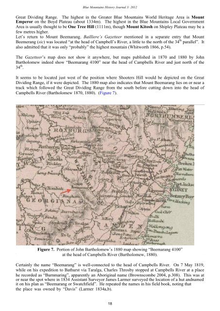
The Gazetteer’s map does not show it anywhere, but maps published in 1870 and 1880 by John<br />
Bartholomew indeed show “Beemarang 4100” near the head of Campbells River and just north of the<br />
34 th .<br />
It seems to be located just west of the position where Shooters Hill would be depicted on the Great<br />
Dividing Range, if it were depicted. The 1880 map also indicates that Mount Beemarang lies on or near a<br />
track which followed the Great Dividing Range from the south before cutting down into the head of<br />
Campbells River (Bartholomew 1870, 1880). (Figure 7).<br />
Figure 7. Portion of John Bartholomew’s 1880 map showing “Beemarang 4100”<br />
at the head of Campbells River (Bartholomew, 1880).<br />
Certainly the name “Beemarang” is well-connected to the head of Campbells River. On 7 May 1819,<br />
while on his expedition to Bathurst via Taralga, Charles Throsby stopped at Campbells River at a place<br />
he recorded as “Burnmaring”, apparently an Aboriginal name (Brownscombe 2004, p.308). This was at<br />
or near the spot where in 1834 Assistant Surveyor James Larmer surveyed the location of a hut andnamed<br />
it on his plan as “Beemarang or Swatchfield”. He repeated the names in his field book, noting that<br />
the place was owned by “Davis” (Larmer 1834a,b).<br />
18