Abstract form
Abstract form
Abstract form

Create successful ePaper yourself
Turn your PDF publications into a flip-book with our unique Google optimized e-Paper software.
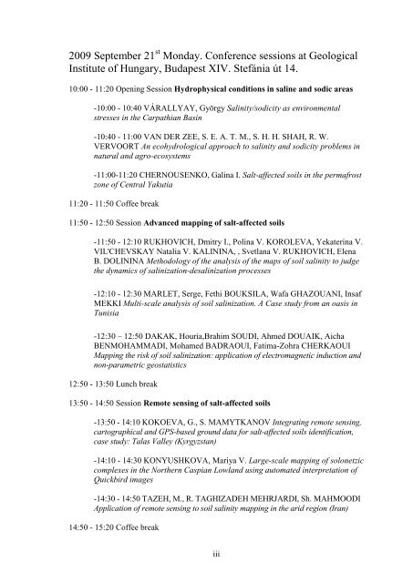
2009 September 21 st Monday. Conference sessions at Geological<br />
Institute of Hungary, Budapest XIV. Stefánia út 14.<br />
10:00 - 11:20 Opening Session Hydrophysical conditions in saline and sodic areas<br />
-10:00 - 10:40 VÁRALLYAY, György Salinity/sodicity as environmental<br />
stresses in the Carpathian Basin<br />
-10:40 - 11:00 VAN DER ZEE, S. E. A. T. M., S. H. H. SHAH, R. W.<br />
VERVOORT An ecohydrological approach to salinity and sodicity problems in<br />
natural and agro-ecosystems<br />
-11:00-11:20 CHERNOUSENKO, Galina I. Salt-affected soils in the permafrost<br />
zone of Central Yakutia<br />
11:20 - 11:50 Coffee break<br />
11:50 - 12:50 Session Advanced mapping of salt-affected soils<br />
-11:50 - 12:10 RUKHOVICH, Dmitry I., Polina V. KOROLEVA, Yekaterina V.<br />
VIL'CHEVSKAY Natalia V. KALININA, , Svetlana V. RUKHOVICH, Elena<br />
B. DOLININA Methodology of the analysis of the maps of soil salinity to judge<br />
the dynamics of salinization-desalinization processes<br />
-12:10 - 12:30 MARLET, Serge, Fethi BOUKSILA, Wafa GHAZOUANI, Insaf<br />
MEKKI Multi-scale analysis of soil salinization. A Case study from an oasis in<br />
Tunisia<br />
-12:30 – 12:50 DAKAK, Houria,Brahim SOUDI, Ahmed DOUAIK, Aicha<br />
BENMOHAMMADI, Mohamed BADRAOUI, Fatima-Zohra CHERKAOUI<br />
Mapping the risk of soil salinization: application of electromagnetic induction and<br />
non-parametric geostatistics<br />
12:50 - 13:50 Lunch break<br />
13:50 - 14:50 Session Remote sensing of salt-affected soils<br />
-13:50 - 14:10 KOKOEVA, G., S. MAMYTKANOV Integrating remote sensing,<br />
cartographical and GPS-based ground data for salt-affected soils identification,<br />
case study: Talas Valley (Kyrgyzstan)<br />
-14:10 - 14:30 KONYUSHKOVA, Mariya V. Large-scale mapping of solonetzic<br />
complexes in the Northern Caspian Lowland using automated interpretation of<br />
Quickbird images<br />
-14:30 - 14:50 TAZEH, M., R. TAGHIZADEH MEHRJARDI, Sh. MAHMOODI<br />
Application of remote sensing to soil salinity mapping in the arid region (Iran)<br />
14:50 - 15:20 Coffee break<br />
iii