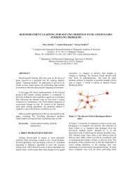
Abstract form
Abstract form
Abstract form

You also want an ePaper? Increase the reach of your titles
YUMPU automatically turns print PDFs into web optimized ePapers that Google loves.
Methodology of the analysis of the maps of soil salinity to judge the<br />
dynamics of salinization-desalinization processes<br />
Dmitry I. RUKHOVICH*, Polina V. KOROLEVA, Yekaterina V. VIL'CHEVSKAY<br />
Natalia V. KALININA, , Svetlana V. RUKHOVICH, Elena B. DOLININA<br />
V.V. Dokuchaev Soil Science Institute, Russian Academy of Agricultural Sciences,<br />
Pyzhevskiy per. 7/2, Moscow, 119017 Russia<br />
*Corresponding author’s e-mail: ruh@agro.geonet.ru<br />
Salinization is one of the most dynamic soil properties. Secondary salinization<br />
intensifies salt transfer in the soil profiles. In the newly irrigated area of the Golodnaya<br />
Steppe (Uzbekistan), the salt status of soils may change from nonsaline to strongly<br />
saline and vice versa within a year. Despite such a considerable dynamism of<br />
salinization–desalinization processes, traditional methods to assess the dynamics of soil<br />
salinity are based on the comparison of two maps of soil salinity developed at different<br />
times with an arbitrarily chosen time interval between them.<br />
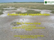
Maps of soil salinity reflect the chemical type and the degree of salinization. Nonsaline,<br />
slightly saline, moderately saline, strongly saline, and very strongly saline soils are<br />
specified. Nonsaline and slightly saline soils can be grouped in one category. Thus, for<br />
the soils with the same chemistry of salinization, four legend units characterize the<br />
degree of salinization. If two maps for different years are compared, seven<br />
combinations are possible: (1–3) soils, whose salinity has decreased by three, two and<br />
one grades, respectively (desalinization of different intensities); (4) soils, whose salinity<br />
has not changed; and (4–7) soils, whose salinity has increased by one, two and three<br />
grades, respectively (salinization of different intensities). It is supposed that the<br />
direction of salinization–desalinization processes in the particular area remains<br />
unchanged during the studied time interval.<br />
We have developed 7 maps of soil salinity for the Usman Yusupov farm (no. 10) in the<br />
Golodnaya Steppe of Uzbekistan for different years from 1983 to 2008 on the basis of<br />
aerial and satellite images. Their analysis proved that the extrapolation or interpolation<br />
of tendencies for a period exceeding one year is incorrect. Thus, a comparison of the<br />
maps for 1983 and 1985 indicates the intense salinization, whereas the maps for 1985<br />
and 1986 indicate the intense desalinization for the same area. If only two maps are<br />
compared, the error of the estimate of salinization–desalinization tendencies may be as<br />
high as 70–80%. To judge the dynamics of these processes, the following series of the<br />
maps is suggested. (1) Maps showing the areas with stable salinization. From year to<br />
year, their portion is about 25% for each salinity grade; for the entire period, it is only<br />
2.5% of the territory. (2) The map showing the trend of salinization (slope of the curve<br />
approximating distribution of saline soils by years); for the studied farm (80 km 2 ), this<br />
map contains more than 50 000 polygons attesting to the high spatial variability of<br />
salinization-desalinization processes. (3) The map of salinization-desalinization<br />
dynamics characterizes the average amplitude (the dynamics coefficient) of salinizationdesalinization<br />
processes. In our case, it was calculated on the basis of five maps for<br />
1983–1989: k = ,5/(׀e-a׀+׀d-e׀+׀c-d׀+׀b-c׀+׀b-׀a) where a, b, c, d and e are the degrees<br />
of soil salinization at a given point (or on a given plot) in 1983, 1985, 1986, 1988 and<br />
1989, respectively. The map demonstrated that the degree of salinization changes by<br />
more than one grade on more than a half of the studied territory. Overall, a set of eight<br />
maps is suggested to judge the dynamics of salinization–desalinization processes.<br />
Key words: soil salinity mapping, salinization–desalinization dynamics, image analysis<br />
35