

Hydrogeology and Groundwater Quality of Highlands ... - USGS
Hydrogeology and Groundwater Quality of Highlands ... - USGS
Hydrogeology and Groundwater Quality of Highlands ... - USGS

You also want an ePaper? Increase the reach of your titles
YUMPU automatically turns print PDFs into web optimized ePapers that Google loves.
The principal source <strong>of</strong> groundwater supply in Highl<strong>and</strong>s<br />
County is the Upper Floridan aquifer. As <strong>of</strong> 2005, about 89<br />
percent <strong>of</strong> the groundwater withdrawn from the county was<br />
obtained from this aquifer. The surficial aquifer was the source<br />
for about 9 percent <strong>of</strong> groundwater (M. Beach, Southwest<br />
Florida Water Management District, written commun., 2009).<br />
Most <strong>of</strong> the water from the surficial aquifer is obtained from<br />
wells along the Lake Wales Ridge. The intermediate aquifer<br />
system is only a minor source <strong>of</strong> water supply, contributing<br />
about 2 percent <strong>of</strong> the total groundwater withdrawn<br />
(M. Beach, Southwest Florida Water Management District,<br />
written commun., 2009).<br />
Although poorly documented, little groundwater is<br />
withdrawn from the Lower Floridan aquifer for water supply<br />
in Highl<strong>and</strong>s County. In the northern part <strong>of</strong> the county<br />
where the top <strong>of</strong> this aquifer is closer to l<strong>and</strong> surface, some<br />
wells may be open to both the Upper Floridan <strong>and</strong> Lower<br />
Floridan aquifers to increase well yields. In much <strong>of</strong> the<br />
county, however, the increased mineralization <strong>of</strong> water from<br />
the Lower Floridan aquifer has prevented it from becoming a<br />
source <strong>of</strong> water supply.<br />
Moderate amounts <strong>of</strong> water are being withdrawn from<br />
surface-water sources, which are primarily used for agricultural<br />
irrigation. Surface-water withdrawals in the study area<br />
are largely from a network <strong>of</strong> canals augmented by groundwater<br />
<strong>and</strong> rainfall. Of the 153.93 Mgal/d <strong>of</strong> surface water<br />
withdrawn in 1975, 58.7 Mgal/d was used for agricultural<br />
irrigation with most <strong>of</strong> the remainder used for power generation.<br />
In 2005, a total <strong>of</strong> only 11.45 Mgal/d <strong>of</strong> surface water<br />
was withdrawn, <strong>of</strong> which 10.94 Mgal/d was used for agricultural<br />
irrigation (Marella, 2009).<br />
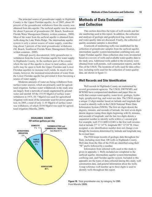
RECREATIONAL<br />
IRRIGATION<br />
2 %<br />
HIGHLANDS COUNTY<br />
107 million gallons per day<br />
DOMESTIC<br />
1 %<br />
PUBLIC<br />
SUPPLY<br />
8 %<br />
THERMOELECTRIC <strong>and</strong><br />
COMMERCIAL / INDUSTRIAL<br />
less than 0.1 %<br />
AGRICULTURE<br />
89 %<br />
Methods <strong>of</strong> Data Evaluation <strong>and</strong> Collection 13<br />
Methods <strong>of</strong> Data Evaluation<br />
<strong>and</strong> Collection<br />
This section describes the types <strong>of</strong> well records <strong>and</strong> the<br />
site numbering used in this report. In addition, the collection<br />
<strong>and</strong> analyses <strong>of</strong> geologic <strong>and</strong> geophysical-log, water-level,<br />
<strong>and</strong> water-quality data are discussed. Finally, the collection <strong>of</strong><br />
quality-assurance samples is described.<br />
A network <strong>of</strong> monitoring wells was established for the<br />
collection <strong>of</strong> groundwater samples from the surficial aquifer,<br />
intermediate aquifer system/intermediate confining unit, <strong>and</strong><br />
Upper Floridan aquifer. Data-collection sites were inventoried<br />
based on a review <strong>of</strong> wells <strong>and</strong> available water-quality data in<br />
the study area. Additional wells added to the inventory were<br />
obtained from well permits, well construction reports, <strong>and</strong> the<br />
files <strong>of</strong> the <strong>USGS</strong>. The locations <strong>of</strong> wells used for data collection,<br />
including wells used for the collection <strong>of</strong> water-quality<br />
data, are shown in figure 11.<br />
Well Records <strong>and</strong> Site Identification<br />
Well records in Highl<strong>and</strong>s County are maintained by<br />
several government agencies. The <strong>USGS</strong>, SWFWMD, <strong>and</strong><br />
SFWMD have computerized databases <strong>and</strong> paper files on<br />
wells that contain water-quality, water-level, geologic, hydrologic,<br />
geophysical-log, <strong>and</strong> water-use data. The <strong>USGS</strong> assigns<br />
a unique 15-digit number based on latitude <strong>and</strong> longitude that<br />
is used to identify wells in the <strong>USGS</strong> National Water Data<br />
Information System (NWIS). The first six digits denote the<br />
degrees, minutes, <strong>and</strong> seconds <strong>of</strong> latitude; the next seven digits<br />
denote degrees (using three digits beginning with 0), minutes,<br />
<strong>and</strong> seconds <strong>of</strong> longitude; <strong>and</strong> the last two digits denote a<br />
sequential number to identify wells within a 1-second grid.<br />
For example, well 271114081122401 is the first well inventoried<br />
at latitude 27° 11′ 14″ N, longitude 081° 12′ 24″ W. Once<br />
assigned, a site identification number does not change even<br />
though the locations determined by latitude <strong>and</strong> longitude may<br />
be revised later.<br />
The FGS keeps records <strong>of</strong> geologic data throughout the<br />
State, including more than 100 wells in Highl<strong>and</strong>s County.<br />
Well data from the files <strong>of</strong> the FGS are identified using their<br />
“W” prefix followed by a number.<br />
Information from selected wells used in this study is<br />
given in appendix 1. Wells included are completed in the<br />
surficial aquifer, intermediate aquifer system/intermediate<br />
confining unit, <strong>and</strong> Floridan aquifer system. Included in this<br />
appendix are the types <strong>of</strong> data collected during this study, well<br />
construction data, <strong>and</strong> general information about the wells.<br />
A map reference well number up to three digits is used to<br />
identify wells throughout this report.<br />
Figure 10. Total groundwater use, by category, for 2005.<br />
From Marella (2009).


