

Hydrogeology and Groundwater Quality of Highlands ... - USGS
Hydrogeology and Groundwater Quality of Highlands ... - USGS
Hydrogeology and Groundwater Quality of Highlands ... - USGS

Create successful ePaper yourself
Turn your PDF publications into a flip-book with our unique Google optimized e-Paper software.
24 <strong>Hydrogeology</strong> <strong>and</strong> <strong>Groundwater</strong> <strong>Quality</strong> <strong>of</strong> Highl<strong>and</strong>s County, Florida<br />
27°30’<br />
27°15’<br />
27°00’<br />
HARDEE<br />
COUNTY<br />
DESOTO<br />
COUNTY<br />
CHARLOTTE<br />
COUNTY<br />
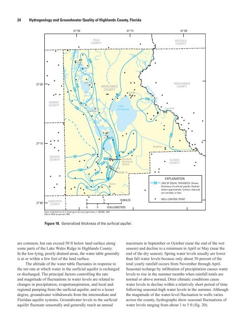
Figure 18. Generalized thickness <strong>of</strong> the surficial aquifer.<br />
are common, but can exceed 50 ft below l<strong>and</strong> surface along<br />
some parts <strong>of</strong> the Lake Wales Ridge in Highl<strong>and</strong>s County.<br />
In the low-lying, poorly drained areas, the water table generally<br />
is at or within a few feet <strong>of</strong> the l<strong>and</strong> surface.<br />
The altitude <strong>of</strong> the water table fluctuates in response to<br />
the net rate at which water in the surficial aquifer is recharged<br />
or discharged. The principal factors controlling the rate<br />
<strong>and</strong> magnitude <strong>of</strong> fluctuations in water levels are related to<br />
changes in precipitation, evapotranspiration, <strong>and</strong> local <strong>and</strong><br />
regional pumping from the surficial aquifer, <strong>and</strong> to a lesser<br />
degree, groundwater withdrawals from the intermediate <strong>and</strong><br />
Floridan aquifer systems. <strong>Groundwater</strong> levels in the surficial<br />
aquifer fluctuate seasonally <strong>and</strong> generally reach an annual<br />
250<br />
200<br />
81°30’ 81°15’<br />
81°00’<br />
100<br />
50<br />
Avon<br />
Park<br />
100<br />
50<br />
200<br />
Sebring<br />
POLK<br />
COUNTY<br />
Kuhlman<br />
200<br />
HIGHLANDS<br />
COUNTY<br />
Lake<br />
Placid<br />
300<br />
250<br />
Base modified from U.S. Geological Survey digital data, 1:100,000, 1985<br />
Albers NAD projection 1983<br />
0<br />
0<br />
100<br />
Hicoria<br />
Venus<br />
Lake<br />
Istokpoga<br />
Lorida<br />
50<br />
Archbold<br />
Biological<br />
Station<br />
ROMP 14<br />
5 10MILES<br />
5 10KILOMETERS<br />
Kissimmee<br />
100<br />
River<br />
Brighton<br />
50<br />
Cornwell<br />
100<br />
OKEECHOBEE<br />
COUNTY<br />
GLADES<br />
COUNTY<br />
OSCEOLA<br />
COUNTY<br />
EXPLANATION<br />
LINE OF EQUAL THICKNESS–Shows<br />
thickness <strong>of</strong> surficial aquifer. Dashed<br />
where approximate. Contour intervals<br />
are variable, in feet.<br />
WELL CONTROL POINT<br />
maximum in September or October (near the end <strong>of</strong> the wet<br />
season) <strong>and</strong> decline to a minimum in April or May (near the<br />
end <strong>of</strong> the dry season). Spring water levels usually are lower<br />
than fall water levels because only about 30 percent <strong>of</strong> the<br />
total yearly rainfall occurs from November through April.<br />
Seasonal recharge by infiltration <strong>of</strong> precipitation causes water<br />
levels to rise in the summer months when rainfall totals are<br />
normal or above normal. Drier climatic conditions cause<br />
water levels to decline within a relatively short period <strong>of</strong> time<br />
following seasonal-high water levels in the summer. Although<br />
the magnitude <strong>of</strong> the water-level fluctuation in wells varies<br />
across the county, hydrographs show seasonal fluctuations <strong>of</strong><br />
water levels ranging from about 1 to 5 ft (fig. 20).


