

Hydrogeology and Groundwater Quality of Highlands ... - USGS
Hydrogeology and Groundwater Quality of Highlands ... - USGS
Hydrogeology and Groundwater Quality of Highlands ... - USGS

Create successful ePaper yourself
Turn your PDF publications into a flip-book with our unique Google optimized e-Paper software.
56 <strong>Hydrogeology</strong> <strong>and</strong> <strong>Groundwater</strong> <strong>Quality</strong> <strong>of</strong> Highl<strong>and</strong>s County, Florida<br />
27°30’<br />
27°15’<br />
27°00’<br />
HARDEE<br />
COUNTY<br />
1,062<br />
936<br />
DESOTO<br />
COUNTY<br />
732<br />
1,102<br />
192<br />
170<br />
1,073<br />
226<br />
821<br />
3,585<br />
1,920<br />
766<br />
CHARLOTTE<br />
COUNTY<br />
Avon<br />
Park<br />
27<br />
242<br />
1,900<br />
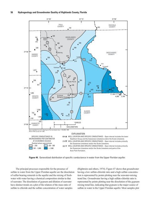
Figure 44. Generalized distribution <strong>of</strong> specific conductance in water from the Upper Floridan aquifer.<br />
The principal processes responsible for the presence <strong>of</strong><br />
sulfate in water from the Upper Floridan aquifer are the dissolution<br />
<strong>of</strong> sulfur-bearing minerals in the aquifer <strong>and</strong> the mixing <strong>of</strong> freshwater<br />
with water having a chemical composition similar to that<br />
<strong>of</strong> seawater. The dissolution <strong>of</strong> gypsum <strong>and</strong> dilution <strong>of</strong> seawater<br />
have distinct trends on a plot <strong>of</strong> the relation <strong>of</strong> the mass ratio <strong>of</strong><br />
sulfate to chloride <strong>and</strong> the sulfate concentration <strong>of</strong> water samples<br />
81°30’ 81°15’<br />
81°00’<br />
98<br />
356<br />
180<br />
243<br />
Kuhlman<br />
498<br />
278<br />
POLK<br />
COUNTY<br />
188<br />
Sebring<br />
479<br />
140<br />
133<br />
341<br />
391<br />
17<br />
249<br />
Archbold 238<br />
Biological Station<br />
383<br />
HIGHLANDS<br />
COUNTY<br />
223<br />
274<br />
Venus<br />
Base modified from U.S. Geological Survey digital data, 1:100,000, 1985<br />
Albers NAD projection 1983<br />
SPECIFIC CONDUCTANCE IN<br />
MICROSIEMENS PER CENTIMETER<br />
AT 25 DEGREES CELSIUS<br />
Dashed where approximate<br />
< 250<br />
250 - 500<br />
501 - 1,000 > 1,000<br />
?<br />
0<br />
0<br />
154<br />
187<br />
Lake Placid<br />
145<br />
27<br />
299<br />
314<br />
189<br />
212<br />
348<br />
Lorida<br />
264<br />
70<br />
5 10MILES<br />
5 10KILOMETERS<br />
98<br />
573<br />
733<br />
812<br />
GLADES<br />
COUNTY<br />
645<br />
453<br />
684<br />
Brighton<br />
711<br />
Cornwell<br />
OSCEOLA<br />
COUNTY<br />
OKEECHOBEE<br />
COUNTY<br />
1,481<br />
1,220 1,662<br />
11,100<br />
4,280 3,190<br />
EXPLANATION<br />
684 WELL LOCATION AND SPECIFIC CONDUCTANCE – Open interval includes the lower<br />
Hawthorn Group <strong>and</strong> the Suwannee Limestone <strong>and</strong>/or the Ocala Limestone.<br />
274 WELL LOCATION AND SPECIFIC CONDUCTANCE – Open interval includes primarily<br />
the Suwannee Limestone <strong>and</strong>/or the Ocala Limestone.<br />
383 WELL LOCATION AND SPECIFIC CONDUCTANCE –<br />
Open interval includes primarily<br />
the Suwannee Limestone <strong>and</strong>/or the Ocala Limestone <strong>and</strong> parts <strong>of</strong> the<br />
Avon Park Formation.<br />
(Rightmire <strong>and</strong> others, 1974). Figure 47 shows that groundwater<br />
having a low sulfate-chloride ratio <strong>and</strong> a high sulfate concentration<br />
is represented by points plotting near the seawater-mixing<br />
trend line. <strong>Groundwater</strong> having a high sulfate-chloride ratio is<br />
represented by points plotting near the dissolution <strong>of</strong> the gypsummixing<br />
trend line, indicating that gypsum is the major source <strong>of</strong><br />
sulfate in water in the Upper Floridan aquifer. Most samples plot


