

Hydrogeology and Groundwater Quality of Highlands ... - USGS
Hydrogeology and Groundwater Quality of Highlands ... - USGS
Hydrogeology and Groundwater Quality of Highlands ... - USGS

You also want an ePaper? Increase the reach of your titles
YUMPU automatically turns print PDFs into web optimized ePapers that Google loves.
27°30’<br />
27°15’<br />
27°00’<br />
29<br />
HARDEE<br />
COUNTY<br />
182<br />
49<br />
11<br />
19<br />
DESOTO<br />
COUNTY<br />
101<br />
5.6<br />
5.5<br />
152<br />
5.4<br />
846<br />
CHARLOTTE<br />
COUNTY<br />
419<br />
92<br />
somewhere between these trend lines, indicating varying degrees<br />
<strong>of</strong> freshwater-seawater mixing <strong>and</strong> gypsum dissolution.<br />
Hardness is used to describe the resistance <strong>of</strong> water to<br />
produce lather from soap. Hardness results from the presence<br />
<strong>of</strong> dissolved calcium <strong>and</strong> magnesium ions, <strong>and</strong> is expressed in<br />
terms <strong>of</strong> equivalent milligrams per liter <strong>of</strong> calcium carbonate<br />
(Hem, 1985). Hardness is classified as s<strong>of</strong>t (0–60 mg/L),<br />
6.6<br />
81°30’ 81°15’<br />
81°00’<br />
Avon<br />
Park<br />
27<br />
6.3<br />
403<br />
98<br />
7.3<br />
7.0<br />
19<br />
POLK<br />
COUNTY<br />
6.1<br />
Kuhlman<br />
11<br />
HIGHLANDS<br />
COUNTY<br />
9.0<br />
5.1<br />
Sebring<br />
8.3<br />
29<br />
6.1<br />
13<br />
13<br />
17<br />
Lake<br />
Placid<br />
6.5<br />
4.5<br />
9.0<br />
4.4<br />
Archbold<br />
Biological<br />
Station<br />
8.2<br />
Base modified from U.S. Geological Survey digital data, 1:100,000, 1985<br />
Albers NAD projection 1983<br />
CHLORIDE CONCENTRATION,<br />
IN MILLIGRAMS PER LITER.<br />
Dashed where approximate<br />
< 10<br />
10 - 25<br />
26 - 250 > 250<br />
0<br />
0<br />
Venus<br />
27<br />
13<br />
8.5<br />
8.4<br />
13<br />
6.4<br />
18<br />
Assessment <strong>of</strong> <strong>Groundwater</strong> <strong>Quality</strong> 57<br />
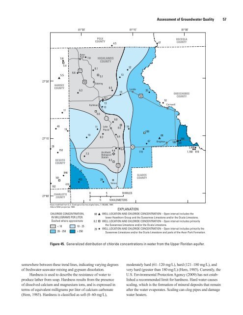
Figure 45. Generalized distribution <strong>of</strong> chloride concentrations in water from the Upper Floridan aquifer.<br />
22<br />
5 10MILES<br />
5 10KILOMETERS<br />
Lorida<br />
? EXPLANATION<br />
70<br />
98<br />
35<br />
108<br />
GLADES<br />
COUNTY<br />
67<br />
47<br />
68<br />
Brighton<br />
OSCEOLA<br />
COUNTY<br />
OKEECHOBEE<br />
COUNTY<br />
52<br />
Cornwell<br />
189<br />
moderately hard (61–120 mg/L), hard (121–180 mg/L), <strong>and</strong><br />
very hard (greater than 180 mg/L) (Hem, 1985). Currently, the<br />
U.S. Environmental Protection Agency (2009) has not established<br />
a recommended limit for hardness. Hard water causes<br />
scaling, which is the formation <strong>of</strong> mineral deposits that remain<br />
after the water evaporates. Scaling can clog pipes <strong>and</strong> damage<br />
water heaters.<br />
301<br />
266<br />
3,480<br />
119 1,160 816<br />
68 WELL LOCATION AND CHLORIDE CONCENTRATION – Open interval includes the<br />
lower Hawthorn Group <strong>and</strong> the Suwannee Limestone <strong>and</strong>/or the Ocala Limestone.<br />
8.2 WELL LOCATION AND CHLORIDE CONCENTRATION – Open interval includes primarily<br />
the Suwannee Limestone <strong>and</strong>/or the Ocala Limestone.<br />
29 WELL LOCATION AND CHLORIDE CONCENTRATION<br />
– Open interval includes primarily the<br />
Suwannee Limestone <strong>and</strong>/or the Ocala Limestone <strong>and</strong> parts <strong>of</strong> the Avon Park Formation.


