

Hydrogeology and Groundwater Quality of Highlands ... - USGS
Hydrogeology and Groundwater Quality of Highlands ... - USGS
Hydrogeology and Groundwater Quality of Highlands ... - USGS

You also want an ePaper? Increase the reach of your titles
YUMPU automatically turns print PDFs into web optimized ePapers that Google loves.
20 <strong>Hydrogeology</strong> <strong>and</strong> <strong>Groundwater</strong> <strong>Quality</strong> <strong>of</strong> Highl<strong>and</strong>s County, Florida<br />
27°30’<br />
27°15’<br />
27°00’<br />
HARDEE<br />
COUNTY<br />
<strong>Hydrogeology</strong><br />
DESOTO<br />
COUNTY<br />
CHARLOTTE<br />
COUNTY<br />
Avon<br />
Park<br />
POLK<br />
COUNTY<br />
GLADES<br />
COUNTY<br />
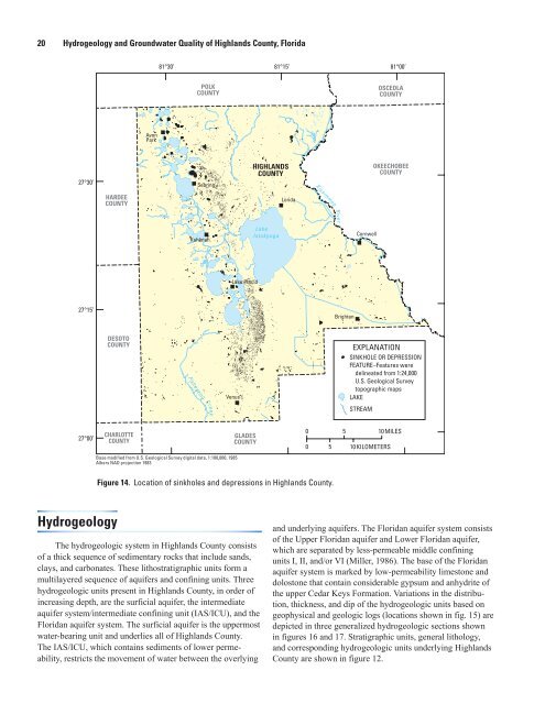
Figure 14. Location <strong>of</strong> sinkholes <strong>and</strong> depressions in Highl<strong>and</strong>s County.<br />
The hydrogeologic system in Highl<strong>and</strong>s County consists<br />
<strong>of</strong> a thick sequence <strong>of</strong> sedimentary rocks that include s<strong>and</strong>s,<br />
clays, <strong>and</strong> carbonates. These lithostratigraphic units form a<br />
multilayered sequence <strong>of</strong> aquifers <strong>and</strong> confining units. Three<br />
hydrogeologic units present in Highl<strong>and</strong>s County, in order <strong>of</strong><br />
increasing depth, are the surficial aquifer, the intermediate<br />
aquifer system/intermediate confining unit (IAS/ICU), <strong>and</strong> the<br />
Floridan aquifer system. The surficial aquifer is the uppermost<br />
water-bearing unit <strong>and</strong> underlies all <strong>of</strong> Highl<strong>and</strong>s County.<br />
The IAS/ICU, which contains sediments <strong>of</strong> lower permeability,<br />
restricts the movement <strong>of</strong> water between the overlying<br />
81°30’ 81°15’<br />
81°00’<br />
Sebring<br />
Kuhlman<br />
Venus<br />
Base modified from U.S. Geological Survey digital data, 1:100,000, 1985<br />
Albers NAD projection 1983<br />
Lake Placid<br />
HIGHLANDS<br />
COUNTY<br />
Lake<br />
Istokpoga<br />
Lorida<br />
0<br />
0<br />
Kissimmee<br />
River<br />
Brighton<br />
Cornwell<br />
OSCEOLA<br />
COUNTY<br />
OKEECHOBEE<br />
COUNTY<br />
EXPLANATION<br />
SINKHOLE OR DEPRESSION<br />
FEATURE–Features were<br />
delineated from 1:24,000<br />
U.S. Geological Survey<br />
topographic maps<br />
LAKE<br />
STREAM<br />
5 10MILES<br />
5 10KILOMETERS<br />
<strong>and</strong> underlying aquifers. The Floridan aquifer system consists<br />
<strong>of</strong> the Upper Floridan aquifer <strong>and</strong> Lower Floridan aquifer,<br />
which are separated by less-permeable middle confining<br />
units I, II, <strong>and</strong>/or VI (Miller, 1986). The base <strong>of</strong> the Floridan<br />
aquifer system is marked by low-permeability limestone <strong>and</strong><br />
dolostone that contain considerable gypsum <strong>and</strong> anhydrite <strong>of</strong><br />
the upper Cedar Keys Formation. Variations in the distribution,<br />
thickness, <strong>and</strong> dip <strong>of</strong> the hydrogeologic units based on<br />
geophysical <strong>and</strong> geologic logs (locations shown in fig. 15) are<br />
depicted in three generalized hydrogeologic sections shown<br />
in figures 16 <strong>and</strong> 17. Stratigraphic units, general lithology,<br />
<strong>and</strong> corresponding hydrogeologic units underlying Highl<strong>and</strong>s<br />
County are shown in figure 12.


