Appendix 1. Inventory <strong>of</strong> wells used in this study.—Continued [Well locations shown in figure 11. Hydrogeologic unit: SA, surficial aquifer; IAS, intermediate aquifer system; UFA, Upper Floridan aquifer; LFA, Lower Floridan aquifer. Primary data type: QW, waterquality sample; WL, groundwater level. Source <strong>of</strong> data: Consult, consultant report; FDEP, Florida Department <strong>of</strong> Environmental Protection; HC, Highl<strong>and</strong>s County; SFWMD, South Florida Water Management District; SWFWMD, Southwest Florida Water Management District; <strong>USGS</strong>, U.S. Geological Survey; —, no data] Well No. <strong>USGS</strong> site ID No. Station name Latitude (degrees, minutes, seconds) Longitude (degrees, minutes, seconds) Bottom <strong>of</strong> casing (feet below l<strong>and</strong> surface) Well depth (feet below l<strong>and</strong> surface) Hydrogeologic unit County Primary data type Source <strong>of</strong> data 149 273333081264301 Altvater Road Surf 273333 812638 9 19 SA Highl<strong>and</strong>s QW SWFWMD 150 273450081170201 AP Air Force Range MW10 273450 811702 2 12 SA Highl<strong>and</strong>s QW <strong>USGS</strong> 151 — ROMP 43 MW1 Surficial 273500 813519 2 12 SA Hardee WL, QW SWFWMD 152 — ROMP 43 MW2 Up Arcadia 273500 813519 52 116 IAS Hardee WL, QW SWFWMD 153 — ROMP 43 MW3 Low Arcadia 273500 813519 196 233 IAS Hardee QW, WL SWFWMD 154 — ROMP 43 MW4 Suwannee 273500 813519 306 464 UFA Hardee QW, WL SWFWMD 155 — ROMP 43 MW5 Avon Park 273500 813519 720 1,210 UFA Hardee WL, QW SWFWMD 156 273517081282801 Sears Rd Surficial 273517 812828 25 35 SA Highl<strong>and</strong>s QW SWFWMD 157 273520081253201 273520081253201 273528 812525 170 190 SA Highl<strong>and</strong>s QW FDEP, SFWMD 158 273525081352101 Thomas Watkins 273526 813522 450 1,200 UFA Hardee QW SWFWMD 159 273528081260901 Lotela_G (MR-0156) 273529 812607 — 10 SA Highl<strong>and</strong>s WL SFWMD, FDEP 160 273603081270501 Wabasso (Dressler) Dairy D 273603 812705 200 350 IAS Highl<strong>and</strong>s WL <strong>USGS</strong> 161 — RIDGE WRAP H-2 Surficial 273611 813143 65 85 SA Highl<strong>and</strong>s WL SWFWMD 162 — LC Dairy 273612 812720 — 20 SA Highl<strong>and</strong>s QW FDEP, SFWMD 163 273615081284901 ROMP 43XX 8”UFA 273616 812848 409 1,363 UFA Highl<strong>and</strong>s QW, WL SWFWMD, <strong>USGS</strong> 164 273615081284902 ROMP 43XX Surficial 273616 812848 32 83 SA Highl<strong>and</strong>s WL SWFWMD 165 273656081210901 AP Air Force Range MW4 273656 812109 2 12 SA Highl<strong>and</strong>s QW <strong>USGS</strong> 166 273704081245501 Richards 273704 812456 140 260 IAS Highl<strong>and</strong>s QW, WL <strong>USGS</strong> 167 273705081290901 CR 627 Surficial 273705 812909 50 60 SA Highl<strong>and</strong>s QW SWFWMD 168 273754081290401 Alpine Road Surficial 273755 812904 66 76 SA Highl<strong>and</strong>s QW SWFWMD 169 273755081253401 HRWRAP H-10 273756 812535 30 50 SA Highl<strong>and</strong>s WL SWFWMD 170 — RIDGE WRAP H-1 Surficial 273816 813125 40 60 SA Highl<strong>and</strong>s WL SWFWMD 171 273845081321901 Clenny UFA 273845 813219 227 1,050 UFA Highl<strong>and</strong>s WL <strong>USGS</strong> 172 273903081185201 Avon Park Prison #1 (POF-9) 273911 812108 — 1,035 UFA Polk WL,QW <strong>USGS</strong> 173 — POS-3 273933 810758 75 90 SA Polk QW, WL SFWMD 174 — POH-1 273933 810759 180 200 IAS Polk QW, WL SFWMD 175 273929081080601 S-65A (POF-20R; 397 ft) 273933 810759 287 397 UFA Polk QW, WL <strong>USGS</strong>, SFWMD 76 <strong>Hydrogeology</strong> <strong>and</strong> <strong>Groundwater</strong> <strong>Quality</strong> <strong>of</strong> Highl<strong>and</strong>s County, Florida
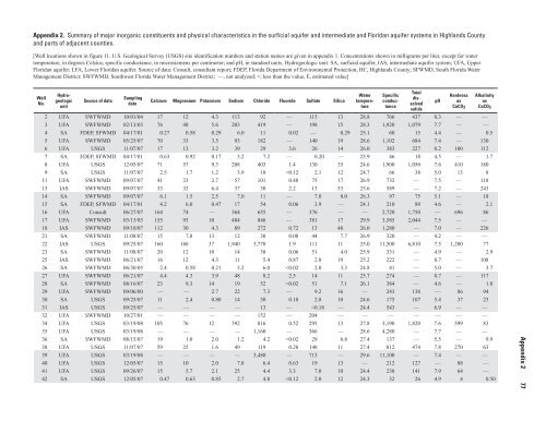
Appendix 2. Summary <strong>of</strong> major inorganic constituents <strong>and</strong> physical characteristics in the surficial aquifer <strong>and</strong> intermediate <strong>and</strong> Floridan aquifer systems in Highl<strong>and</strong>s County <strong>and</strong> parts <strong>of</strong> adjacent counties. [Well locations shown in figure 11. U.S. Geological Survey (<strong>USGS</strong>) site identification numbers <strong>and</strong> station names are given in appendix 1. Concentrations shown in milligrams per liter, except for water temperature, in degrees Celsius; specific conductance, in microsiemens per centimeter; <strong>and</strong> pH, in st<strong>and</strong>ard units. Hydrogeologic unit: SA, surficial aquifer, IAS, intermediate aquifer system; UFA, Upper Floridan aquifer; LFA, Lower Floridan aquifer. Source <strong>of</strong> data: Consult, consultant report; FDEP, Florida Department <strong>of</strong> Environmental Protection; HC, Highl<strong>and</strong>s County; SFWMD, South Florida Water Management District; SWFWMD, Southwest Florida Water Management District; —, not analyzed;