
Create successful ePaper yourself
Turn your PDF publications into a flip-book with our unique Google optimized e-Paper software.
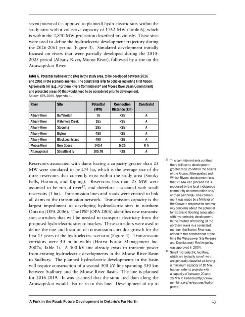
seven potential (as opposed to planned) hydroelectric sites within the<br />
study area with a collective capacity of 1762 MW (Table 6), which<br />
is within the 2,850 MW projection described previously. These sites<br />
were used to define the hydroelectric development trajectory during<br />
the 2026-2061 period (Figure 3). Simulated development initially<br />
focused on rivers that were partially developed during the 2010-<br />
2025 period (Albany River, Moose River), followed by a site on the<br />
Attawapiskat River.<br />
Table 6. Potential hydroelectric sites in the study area, to be developed between 2026<br />
and 2061 in the scenario analysis. The constraints refer to policies including First Nation<br />
Agreements (A) (e.g., Northern Rivers Commitment 16 and Moose River Basin Commitment)<br />
and protected areas (P) that would need to be considered prior to development.<br />
Source: OPA 2005, Appendix 1.<br />
River Site Potential<br />
(MW)<br />
Connection<br />
Distance (km)<br />
Constraint<br />
Albany River Buffaloskin 76 >25 A<br />
Albany River Wabimeig Creek 185 >25 A<br />
Albany River Stooping 285 >25 A<br />
Albany River Biglow 480 >25 A<br />
Albany River Blackbear Island 490 >25 A<br />
Moose River Grey Goose 140.4 5-25 P, A<br />
Attawapiskat Streatfield IV 105.76 >25 A<br />
Reservoirs associated with dams having a capacity greater than 25<br />
MW were simulated to be 274 ha, which is the average size of the<br />
three reservoirs that currently exist within the study area (Smoky<br />
Falls, Harmon, and Kipling). Reservoirs less than 25 MW were<br />
assumed to be run-of-river 17 , and therefore associated with small<br />
reservoirs (1 ha). Transmission lines and roads were created to link<br />
all dams to the transmission network. Transmission capacity is the<br />
largest impediment to developing hydroelectric sites in northern<br />
Ontario (OPA 2006). The IPSP (OPA 2006) identifies new transmission<br />
corridors that will be needed to transport electricity from the<br />
proposed hydroelectric sites to market. These corridors were used to<br />
define the rate and location of transmission corridor growth for the<br />
first 15 years of the hydroelectric scenario (Figure 4). Transmission<br />
corridors were 40 m in width (Hearst Forest Management Inc.<br />
2007a, Table 1). A 500 kV line already exists to transmit power<br />
from existing hydroelectric developments in the Moose River Basin<br />
to Sudbury. The planned hydroelectric developments in the basin<br />
will require construction of a second 500 kV line spanning 550 km<br />
between Sudbury and the Moose River Basin. The line is planned<br />
for 2016-2019. It was assumed that the simulated dam along the<br />
Attawapiskat would also tie in to this line. Development of up to<br />
16<br />
This commitment sets out that<br />
there will be no development<br />
greater than 25 MW in the basins<br />
of the Albany, Attawapiskat and<br />
Winisk Rivers; development less<br />
that 25 MW can proceed if it is<br />
proposed by the local indigenous<br />
community or communities and/<br />
or their partner(s). This commitment<br />
was made by a Minister of<br />
the Crown in response to community<br />
concerns about the potential<br />
for extensive flooding associated<br />
with hydroelectric development.<br />
In the interest of treating all the<br />
northern rivers in a consistent<br />
manner, the Severn River was<br />
added to this commitment at the<br />
time the Waterpower Site Release<br />
and Development Review policy<br />
was approved in 2004.<br />
17 Small hydroelectric facilities,<br />
which are typically run-of-river,<br />
are generally classified as having<br />
a maximum capacity of 10 MW<br />
but can refer to projects with<br />
a capacity of between 20 and<br />
25 MW in <strong>Canada</strong> (http://www.<br />
pembina.org/re/sources/hydropower).<br />
A Fork in the Road: Future Development in Ontario’s Far North<br />
13


![RaLand / SeaScape [PDF] - Wildlife Conservation Society](https://img.yumpu.com/49974326/1/190x245/raland-seascape-pdf-wildlife-conservation-society.jpg?quality=85)