
Create successful ePaper yourself
Turn your PDF publications into a flip-book with our unique Google optimized e-Paper software.
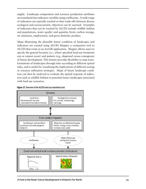
supply. Landscape composition and resource production attributes<br />
are translated into indicator variables using coefficients. A wide range<br />
of indicators are typically tracked so that trade-offs between diverse<br />
ecological and socioeconomic objectives can be assessed. Examples<br />
of indicators that can be tracked by ALCES include wildlife habitat<br />
and populations, water quality and quantity, biotic carbon storage,<br />
air emissions, employment, and gross domestic product.<br />
Maps illustrating the plausible future condition of landscapes and<br />
indicators are created using ALCES Mapper, a companion tool to<br />
ALCES that exists as an ArcGIS application. Mapper allows users to<br />
specify the general location (i.e., where specified land-use footprints<br />
can or cannot occur) and pattern (e.g., dispersed versus contagious)<br />
of future development. This feature provides flexibility to map transformations<br />
of landscapes through time according to different spatial<br />
rules, and is useful for visualizing the implications of different zoning<br />
or resource utilization strategies. Maps of future landscape condition<br />
can then be analyzed to evaluate the spatial response of indicators<br />
such as wildlife habitat to potential future landscapes associated<br />
with land-use scenarios.<br />
Figure 17. Overview of the ALCES land use simulation tool.<br />
A Fork in the Road: Future Development in Ontario’s Far North<br />
59
![RaLand / SeaScape [PDF] - Wildlife Conservation Society](https://img.yumpu.com/49974326/1/190x245/raland-seascape-pdf-wildlife-conservation-society.jpg?quality=85)