CAST Fiscal Year 2004-2005 Annual Report - Center for Advanced ...
CAST Fiscal Year 2004-2005 Annual Report - Center for Advanced ...
CAST Fiscal Year 2004-2005 Annual Report - Center for Advanced ...

You also want an ePaper? Increase the reach of your titles
YUMPU automatically turns print PDFs into web optimized ePapers that Google loves.
transmitter only becomes active <strong>for</strong> a short<br />
period of time every two to four days. During the<br />
active period it collects as many locations as<br />
possible within the pre-programmed time frame.<br />
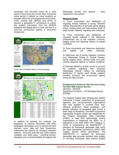
<strong>CAST</strong> worked with ARGOS and AFGC to<br />
develop a geospatial IT architecture to extract<br />
this position in<strong>for</strong>mation from the ARGOS<br />
database and display them in near real time in a<br />
web-map environment against a land-cover<br />
background.<br />
Mississippi fly-way and beyond – have<br />
registered on the system.<br />
Research Goals<br />
1) Track movements and distribution of<br />
migrating female mallards in spring. Describe<br />
habitat characteristics of principle spring staging<br />
areas, nesting areas and post-nesting areas of<br />
adult female mallards migrating from Arkansas.<br />
2) Track movements and distribution of<br />
migrating female mallards in fall. Determine<br />
proportionate use of fall migration corridors,<br />
staging areas and dispersal relative to habitat<br />
conditions.<br />
3) Track movements and determine distribution<br />
and habitat use within Arkansas.<br />
4) Determine use of spring migration corridors<br />
(e.g. Mississippi Flyway or Central Flyway),<br />
spring staging areas, nesting areas and postnesting<br />
dispersal relative to habitat conditions.<br />
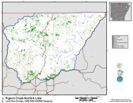
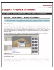
Screen shots of Satellite Mallard Tracking webpage.<br />
5) Estimate efficiency of May survey to account<br />
<strong>for</strong> mallards migrating from Arkansas<br />
(Mississippi Alluvial Valley) by estimating<br />
distribution of marked adult female mallards<br />
between surveyed and un-surveyed regions<br />
during the May surveys.<br />
Establishing Framework Data Services Using<br />
the OGC Web Feature Service<br />
08/20/04 – 09/30/05<br />
Department of Interior – US Geological Survey<br />
$74,966.<br />
In addition, to tracking the mallards, the<br />
integration of tracking in<strong>for</strong>mation with other<br />
geographic in<strong>for</strong>mation such as climate and land<br />
use/land cover data will help researchers<br />
understand the reasons <strong>for</strong> changing migration<br />
patterns. Since the web-site was made publicly<br />
available, over 3000 users – including hunters,<br />
biologists and environmentalists throughout the<br />
The National Spatial Data Infrastructure (NSDI)<br />
represents a broad consortium of government<br />
agencies and non-government organizations<br />
that work together to promote more costeffective<br />
production, ready availability, and<br />
greater utilization of geospatial data across a<br />
wide range of disciplines. The NSDI Cooperative<br />
Agreements Program (CAP) was established by<br />
the Federal Geographic Data Committee<br />
(FGDC) to help <strong>for</strong>m partnerships among<br />
organizations to implement the NSDI. As a<br />
participant in the <strong>2004</strong> NSDI CAP Category 5,<br />
<strong>CAST</strong> is implementing the ANSI/INCITS L1<br />
standard <strong>for</strong> framework geospatial data using<br />
the Open Geospatial Consortium's (OGC) Web<br />
Feature Service (WFS) specification. The<br />
ANSI/INCITS L1 standard <strong>for</strong> framework<br />
geospatial data provides standard data models<br />
or encoding framework data themes (Digital<br />
34 CENTER FOR ADVANCED SPATIAL TECHNOLOGIES