CAST Fiscal Year 2004-2005 Annual Report - Center for Advanced ...
CAST Fiscal Year 2004-2005 Annual Report - Center for Advanced ...
CAST Fiscal Year 2004-2005 Annual Report - Center for Advanced ...

You also want an ePaper? Increase the reach of your titles
YUMPU automatically turns print PDFs into web optimized ePapers that Google loves.
R<br />
E<br />
S<br />
E<br />
A<br />
R<br />
C<br />
H<br />
RESEARCH FUNDING.<br />
A total of 20 new research proposals were<br />
funded in <strong>Fiscal</strong> <strong>Year</strong> <strong>2005</strong> with a total award<br />
amount of $1,866,665.<br />
Page 27<br />
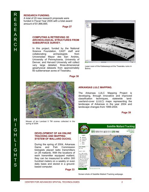
COMPUTING & RETRIEVING 3D<br />
ARCHEOLOGICAL STRUCTURES FROM<br />
SUBSURFACE SURVEY.<br />
In this project, funded by the National<br />
Science Foundation, <strong>CAST</strong> staff and<br />
collaborating archeologists from<br />
Universidad Mayor des San Andres,<br />
University of Pennsylvania, University of<br />
Denver, and Harvard University will collect<br />
very large detailed, three-dimensional<br />
geophysical datasets from approximately<br />
60 subterranean acres of Tiwanaku.<br />
Page 38<br />
Laser scan of the Kalasasaya at the Tiwanaku ruins in<br />
Boliva.<br />
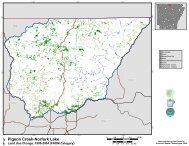
ARKANSAS LULC MAPPING.<br />
The Arkansas LULC Mapping Project is<br />
developing, through innovative and improved<br />
classification techniques, statewide landuse/land-cover<br />
(LULC) maps representing the<br />
landscape of Arkansas in the year <strong>2004</strong> and<br />
landscape changes from 1999-<strong>2004</strong>.<br />
Page 39<br />
H<br />
I<br />
G<br />
H<br />
L<br />
I<br />
G<br />
H<br />
T<br />
S<br />
Mosaic of ten Landsat 5 TM scenes collected in the<br />
spring of <strong>2004</strong>.<br />
DEVELOPMENT OF AN ONLINE<br />
TRACKING AND MAPPING<br />
SYSTEM OF MALLARD DUCKS.<br />
During the spring of <strong>2004</strong>, Arkansas<br />
Game and Fish Commission<br />
biologists placed radio transmitters<br />
on 28 mallards. With the locations of<br />
each transmitter equipped mallard,<br />
they can be measured to within 300<br />
hundred meters on a weekly or even<br />
daily basis and stored in a groundbased<br />
computer.<br />
Page 33<br />
Screen shots of Satellite Mallard Tracking webpage.<br />
CENTER FOR ADVANCED SPATIAL TECHNOLOGIES 2