CAST Fiscal Year 2004-2005 Annual Report - Center for Advanced ...
CAST Fiscal Year 2004-2005 Annual Report - Center for Advanced ...
CAST Fiscal Year 2004-2005 Annual Report - Center for Advanced ...

Create successful ePaper yourself
Turn your PDF publications into a flip-book with our unique Google optimized e-Paper software.
agency that conducts the final checks on the<br />
overall quality of the work and has the final<br />
approval authority be<strong>for</strong>e submitting the soil<br />
survey <strong>for</strong> SSURGO certification. As of June<br />
<strong>2005</strong> the following counties have been digitized<br />
and submitted to NRCS <strong>for</strong> quality control and<br />
certification: Pike, Ouachita, Calhoun, Bradley,<br />
Dallas and Cleaveland. The project also focuses<br />
on developing communication tools <strong>for</strong> the soil<br />
data <strong>for</strong> professionals and general public<br />
interested in the soil in<strong>for</strong>mation. Once the soil<br />
surveys become SSURGO certified, compiled<br />
datasets of selected soil attributes are<br />
manipulated in an appropriate GIS <strong>for</strong>mat and<br />
published within the on-line data delivery system<br />
GeoStor<br />
(http://www.cast.uark.<br />
edu/cast/geostor/) hosted at <strong>CAST</strong>. Presently,<br />
there are more than 30 counties available <strong>for</strong><br />
download with in<strong>for</strong>mation including general soil<br />
in<strong>for</strong>mation, crops suitability, soil surface layer<br />
properties and soil use interpretation<br />
(representing more than 200 soil attributes).<br />
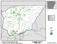
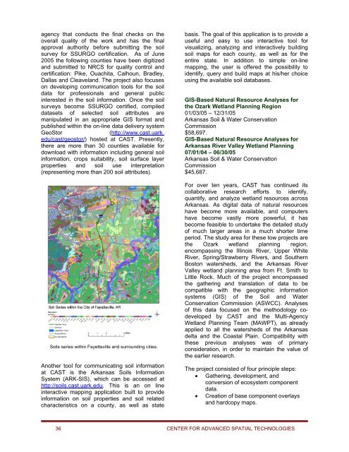
Soils series within Fayetteville and surrounding cities.<br />
Another tool <strong>for</strong> communicating soil in<strong>for</strong>mation<br />
at <strong>CAST</strong> is the Arkansas Soils In<strong>for</strong>mation<br />
System (ARK-SIS), which can be accessed at<br />
http://soils.cast.uark.edu. This is an on line<br />
interactive mapping application built to provide<br />
in<strong>for</strong>mation on soil properties and soil related<br />
characteristics on a county, as well as state<br />
basis. The goal of this application is to provide a<br />
useful and easy to use interactive tool <strong>for</strong><br />
visualizing, analyzing and interactively building<br />
soil maps <strong>for</strong> each county, as well as <strong>for</strong> the<br />
entire state. In addition to simple on-line<br />
mapping, the user is offered the possibility to<br />
identify, query and build maps at his/her choice<br />
using the available soil databases.<br />
GIS-Based Natural Resource Analyses <strong>for</strong><br />
the Ozark Wetland Planning Region<br />
01/03/05 – 12/31/05<br />
Arkansas Soil & Water Conservation<br />
Commission<br />
$58,697.<br />
GIS-Based Natural Resource Analyses <strong>for</strong><br />
Arkansas River Valley Wetland Planning<br />
07/01/04 – 06/30/05<br />
Arkansas Soil & Water Conservation<br />
Commission<br />
$45,687.<br />
For over ten years, <strong>CAST</strong> has continued its<br />
collaborative research ef<strong>for</strong>ts to identify,<br />
quantify, and analyze wetland resources across<br />
Arkansas. As digital data of natural resources<br />
have become more available, and computers<br />
have become vastly more powerful, it has<br />
become feasible to undertake the detailed study<br />
of much larger areas in a much shorter time<br />
period. The study area <strong>for</strong> these tow projects are<br />
the Ozark wetland planning region,<br />
encompassing the Illinois River, Upper White<br />
River, Spring/Strawberry Rivers, and Southern<br />
Boston watersheds, and the Arkansas River<br />
Valley wetland planning area from Ft. Smith to<br />
Little Rock. Much of the project encompassed<br />
the gathering and translation of data to be<br />
compatible with the geographic in<strong>for</strong>mation<br />
systems (GIS) of the Soil and Water<br />
Conservation Commission (ASWCC). Analyses<br />
of this data focused on the methodology codeveloped<br />
by <strong>CAST</strong> and the Multi-Agency<br />
Wetland Planning Team (MAWPT), as already<br />
applied to all the watersheds of the Arkansas<br />
delta and the Coastal Plain. Compatibility with<br />
these previous analyses was of primary<br />
consideration, in order to maintain the value of<br />
the earlier research.<br />
The project consisted of four principle steps:<br />
• Gathering, development, and<br />
conversion of ecosystem component<br />
data.<br />
• Creation of base component overlays<br />
and hardcopy maps.<br />
36 CENTER FOR ADVANCED SPATIAL TECHNOLOGIES