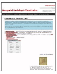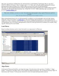
CAST Fiscal Year 2004-2005 Annual Report - Center for Advanced ...
CAST Fiscal Year 2004-2005 Annual Report - Center for Advanced ...
CAST Fiscal Year 2004-2005 Annual Report - Center for Advanced ...

You also want an ePaper? Increase the reach of your titles
YUMPU automatically turns print PDFs into web optimized ePapers that Google loves.
Board, and the UA In<strong>for</strong>mation Technology<br />
Research Institute.<br />
STATE SERVICE.<br />
The <strong>Center</strong> provides a range of public service<br />
throughout the state. In the last fiscal years, an<br />
important arena of assistance was to support the<br />
legislature in a variety of initiatives. Special<br />
demonstration ef<strong>for</strong>ts were offered to legislators<br />
such as Shane Broadway, Jim Argue, Sue<br />
Madison, and Jan Judy, to the Legislative<br />
Research Bureau as well as help provided to the<br />
Arkansas Geographic In<strong>for</strong>mation Office in a<br />
number of areas.<br />
<strong>CAST</strong> staff are actively supporting Arkansas’<br />
(and other state’s) schools and communities<br />
through the EAST Project and AmericaView<br />
programs, described in detail in the Research<br />
section. Among the Arkansas schools visited by<br />
EAST were: Little Rock, Fayetteville,<br />
Farmington, Gravette, Lincoln, Perryville,<br />
Clinton, Southside, Dumas, Cave, Henderson,<br />
Morrilton, Camden, Lake Village, McGehee,<br />
Smackover, Augusta, Brinkley, Vilonia, and<br />
Greenbrier. Outside the state, schools were<br />
visited or school workshops were offered in<br />
Chicago IL, Eureka CA, Berkeley CA, and<br />
Sacramento CA.<br />
Bruce Gorham provided a wide range of<br />
assistance to groups around the state in the<br />
selection of image product and data, al well as in<br />
acquiring and using GPS data.<br />
Brian Culpepper compiled a statewide<br />
population change report <strong>for</strong> each eco-region of<br />
Arkansas <strong>for</strong> the AGFC’s Forest legacy project.<br />
James Sullins and Brian Culpepper published all<br />
of Arkansas’ color IR aerial photography base<br />
data into the USGS National Map program and<br />
continue to maintain this web service <strong>for</strong> the<br />
State of Arkansas without external support.<br />
Carroll County participants in the LeadAR<br />
program were provided an overview of<br />
geospatial technologies <strong>for</strong> rural decision<br />
support by <strong>CAST</strong> staff. Eighteen local<br />
government employees were given professional<br />
short-course training scholarships (worth $450<br />
each) <strong>for</strong> the Introduction to ArcGIS I shortcourses<br />
taught by John Wilson and Brian<br />
Culpepper.<br />
LOCAL SERVICE.<br />
Cristina Scarlat, Jack Cothren, and Brian<br />
Culpepper provided an extensive amount of<br />
technical assistance to many groups in<br />
Northwest Arkansas, particularly to the<br />
Northwest Arkansas Planning Commission and<br />
to the Northwest Arkansas Image Acquisition<br />
Task Force in their very successful region-wide<br />
image and LIDAR data acquisition ef<strong>for</strong>t. As<br />
part of that ef<strong>for</strong>t, Culpepper also completed a<br />
horizontal accuracy assessment of the <strong>2004</strong><br />
Washington County ortho-imagery. Scarlat also<br />
aided the Planning Commission in their regional<br />
transportation planning ef<strong>for</strong>ts. Cothren served<br />
as a Northwest Arkansas Science Fair Judge.<br />
The online mapping application <strong>for</strong> Northwest<br />
Arkansas (www.rgis.cast.uark.edu) was<br />
launched in March of <strong>2005</strong>, and over 50 new<br />
users register <strong>for</strong> this application each month to<br />
receive free access to current photography and<br />
base maps of Benton and Washington Counties.<br />
<strong>CAST</strong> staff provided imagery data and data<br />
<strong>for</strong>matting assistance to the City of Fayetteville<br />
and Washington County 911 and created a<br />
single-band, black-and-white mosaic of the new<br />
Northwest Arkansas imagery.<br />
CAMPUS SERVICE.<br />
The <strong>Center</strong> has active service ef<strong>for</strong>ts with a wide<br />
range of campus units. John Wilson provides<br />
dozens of units on the campus with ESRI<br />
software technical support. The <strong>Center</strong> works<br />
closely with the UA <strong>Center</strong> <strong>for</strong> Economic<br />
Development, Facilities Management, UA<br />
Extension, and Many other departments.<br />
The <strong>Center</strong>’s teaching labs are used <strong>for</strong> 14<br />
different courses by faculty from Crop, Soil and<br />
Environmental Science, Anthropology, Biology,<br />
Ag and Biological Engineering, Classics, Drama,<br />
Geosciences, and Landscape Architecture.<br />
Extensive technical support has been provided<br />
to Dr. Otto Loewer of the UAEDI program.<br />
Assistance was also provided this year to UAMS<br />
Little Rock’s Arkansas <strong>Center</strong> <strong>for</strong> Health<br />
In<strong>for</strong>mation and UCA’s Department of<br />
Geography.<br />
CENTER FOR ADVANCED SPATIAL TECHNOLOGIES 47