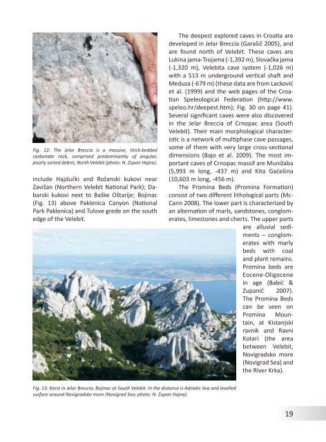
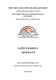
Fig. 12: The Jelar Breccia is a massive, thick-beddedcarbonate rock, comprised predominantly <strong>of</strong> angular,poorly sorted debris; North Velebit (photo: N. Zupan Hajna).include Hajdučki and Rožanski kukovi nearZavižan (Nor<strong>the</strong>rn Velebit National Park); Dabarskikukovi next to Baške Oštarije; Bojinac(Fig. 13) above Paklenica Canyon (NationalPark Paklenica) and Tulove grede on <strong>the</strong> sou<strong>the</strong>dge <strong>of</strong> <strong>the</strong> Velebit.The deepest explored caves in Croatia aredeveloped in Jelar Breccia (Garašič 2005), andare found north <strong>of</strong> Velebit. These caves areLukina jama-Trojama (-1,392 m), Slovačka jama(-1,320 m), Velebita cave system (-1,026 m)with a 513 m underground vertical shaft andMeduza (-679 m) (<strong>the</strong>se data are <strong>from</strong> Lackovićet al. (1999) and <strong>the</strong> web pages <strong>of</strong> <strong>the</strong> CroatianSpeleological Federation (http://www.speleo.hr/deepest.htm); Fig. 30 on page 41).Several significant caves were also discoveredin <strong>the</strong> Jelar Breccia <strong>of</strong> Crnopac area (SouthVelebit). Their main morphological characteristicis a network <strong>of</strong> multiphase cave passages,some <strong>of</strong> <strong>the</strong>m with very large cross-sectionaldimensions (Bajo et al. 2009). The most importantcaves <strong>of</strong> Crnopac massif are Munižaba(5,993 m long, -437 m) and Kita Gaćešina(10,603 m long, -456 m).The Promina Beds (Promina Formation)consist <strong>of</strong> two different lithological parts (Mc-Cann 2008). The lower part is characterized byan alternation <strong>of</strong> marls, sandstones, conglomerates,limestones and cherts. The upper partsare alluvial sediments– conglomerateswith marlybeds with coaland plant remains.Promina beds areEocene-Oligocenein age (Babić &Zupanič 2007).The Promina Bedscan be seen onPromina Mountain,at Kistanjskiravnik and RavniKotari (<strong>the</strong> areabetween Velebit,Novigradsko more(Novigrad Sea) and<strong>the</strong> River Krka).Fig. 13: <strong>Karst</strong> in Jelar Breccia; Bojinac at South Velebit. In <strong>the</strong> distance is Adriatic Sea and levelledsurface around Novigradsko more (Novigrad Sea; photo: N. Zupan Hajna).19
ClimateMitja PrelovšekThe <strong>Dinaric</strong> karst is situated between42° and 46° N at <strong>the</strong> nor<strong>the</strong>astern edge <strong>of</strong> <strong>the</strong>Mediterranean Sea. From a climatic point <strong>of</strong>view, this geographic position falls within atemperate climatic zone where mid-latitudewesterly winds (westerlies) prevail throughout<strong>the</strong> year. Never<strong>the</strong>less, <strong>the</strong> declination <strong>of</strong> <strong>the</strong>Earth and its movement around <strong>the</strong> Sun shifts<strong>the</strong> position <strong>of</strong> temperate belt 23° northwardduring summer and southward again duringwinter. This means that <strong>the</strong>se latitudes canbe under a strong subtropical zone influenceduring <strong>the</strong> summer months and under <strong>the</strong> influence<strong>of</strong> polar fronts during winter since <strong>the</strong>polar front can move southward <strong>of</strong> Greece(Kocsis 2007). Westerlies can <strong>the</strong>refore be verydry during several summer months but alsovery wet during winter.Besides <strong>the</strong> global atmospheric circulationsystem, <strong>the</strong> climate <strong>of</strong> <strong>the</strong> <strong>Dinaric</strong> karstis strongly influenced by <strong>the</strong> Dinarsko gorovje(<strong>Dinaric</strong> Mountains), which form an orographicbarrier that affects precipitation patterns(Fig. 16) and hinders winter intrusions <strong>of</strong>cold polar air flowing <strong>from</strong> continental regionsin <strong>the</strong> east toward Adriatic coast. Westerliesusually blow <strong>from</strong> <strong>the</strong> Atlantic Ocean over <strong>the</strong>warm Mediterranean Sea. If <strong>the</strong> pressure islow over <strong>the</strong> Mediterranean Sea, air massesbecome enriched with humidity. When <strong>the</strong>yhit <strong>the</strong> Dinarsko gorovje, <strong>the</strong> result is a highamount <strong>of</strong> precipitation on <strong>the</strong> west-facingside (Crkvice, Orjen-5,317 mm/a-<strong>the</strong> highestamount in Europe; Rodić 1987) and a muchsmaller amount <strong>of</strong> precipitation on <strong>the</strong> eastfacingside. Lower amounts <strong>of</strong> precipitation arealso characteristic for low-lying areas along <strong>the</strong>Adriatic coast and low islands (e.g., Pula-713mm/a, Vis-676 mm/a; Rodič 1987). In summer,high pressure over <strong>the</strong> Mediterranean Seahinders uplifting and condensation <strong>of</strong> <strong>the</strong> airmasses over <strong>the</strong> sea, while over <strong>the</strong> continentprecipitation is possible due to strong convection.In winter, <strong>the</strong> Dinarsko gorovje preventintrusions <strong>of</strong> cool air masses that develop overcontinental Eastern Europe. Never<strong>the</strong>less, if<strong>the</strong> pressure difference between marine andcontinental air masses is too high, pockets <strong>of</strong>cold air spill over <strong>the</strong> orographic barrier, causingstrong katabatic winds called “<strong>the</strong> Bora”,which can exceed even 200 km/h. The mainridge <strong>of</strong> <strong>the</strong> Dinarsko gorovje, which rangesin altitude <strong>from</strong> 612 m to more than 2,500 m,also causes a strong vertical decline <strong>of</strong> temperature.Average annual temperatures decreasewith height over quite short horizontal distances(80 km) <strong>from</strong> 15.3 °C (Podgorica; Kovacs& Dobos 2007) to about 2°C (Durmitor). Evensteeper spatial temperature changes are characteristicfor mountain Velebit. At such highaltitudes, snow is present for up to half a year.The Adriatic Sea has a strong moderatinginfluence especially on temperatures along<strong>the</strong> coast and islands. Along <strong>the</strong> coast, at <strong>the</strong>southwestern boundary <strong>of</strong> <strong>the</strong> <strong>Dinaric</strong> karst,winter temperatures are much higher in comparisonwith places on <strong>the</strong> nor<strong>the</strong>astern edge<strong>of</strong> <strong>the</strong> <strong>Dinaric</strong> karst. Along <strong>the</strong> coast, temperaturesbelow zero are rare even during winterbut very common on <strong>the</strong> continental edge<strong>of</strong> <strong>the</strong> <strong>Dinaric</strong> karst at only slightly higher altitudes(~170 m a.s.l.). Consequently, snowat <strong>the</strong> coast is very rare, but not impossible(when it does occur, it is always related to<strong>the</strong> intrusion <strong>of</strong> cold continental air <strong>from</strong> <strong>the</strong>nor<strong>the</strong>ast). In summer, daily temperaturesalong <strong>the</strong> coast are usually lower than in <strong>the</strong>continental part <strong>of</strong> <strong>the</strong> <strong>Dinaric</strong> karst due to <strong>the</strong>20
- Page 2 and 3: Andrej Mihevc, Mitja Prelovšek, Na
- Page 4 and 5: ContentsGeographical Position and G
- Page 7 and 8: Fig. 2: Coastal part of Dinaric kar
- Page 9 and 10: ogy started. In 1531 a lawyer from
- Page 11 and 12: include numerous data and general o
- Page 13 and 14: GeologyNadja Zupan HajnaThe Dinaric
- Page 15 and 16: ceous. The final disintegration of
- Page 17: Fig. 11: Locations of Jelar Breccia
- Page 21 and 22: 311 mm/a; Zaninović 2008) and incr
- Page 23 and 24: 24Fig. 16: Spatial distribution of
- Page 25 and 26: ocks (such as Eocene flysch, Lower
- Page 27 and 28: absent. Downstreamparts of the cany
- Page 29 and 30: GeomorphologyAndrej MihevcIn folk l
- Page 31 and 32: long. They are smoother especially
- Page 33 and 34: is now depositing. Best known are t
- Page 35 and 36: Structural poljes are dominated by
- Page 37 and 38: Fig. 28: Typical dolines of Dinaric
- Page 39 and 40: the disintegrated collapsed rock at
- Page 41 and 42: on Northern Velebit, where three ca
- Page 43 and 44: Land UseNadja Zupan Hajna, Andrej M
- Page 45 and 46: for ‘bare limestone desert’ -th
- Page 47 and 48: Fig. 38: Grančarevo dam in the upp
- Page 49 and 50: KrasThe Kras is a distinct plateau,
- Page 51 and 52: in this part of the Kras (Mihevc 20
- Page 53 and 54: dolomite barrier along the Idrija w
- Page 55 and 56: of Dolenjska (Gams, 1974; Kranjc, 1
- Page 57 and 58: Fig. 44: Blind valleys of Matarsko
- Page 59 and 60: ly several dozen meters deep. Shaft
- Page 61 and 62: smaller than the higher ones. The r
- Page 63 and 64: tion in the Divaški kras (Mihevc 1
- Page 65 and 66: Use of Karst and its ProtectionThe
- Page 67 and 68: Gams, I., Vrišer, I. (Eds.), 1998:
- Page 69 and 70:
lems.- Dela 38, Raziskovalni center