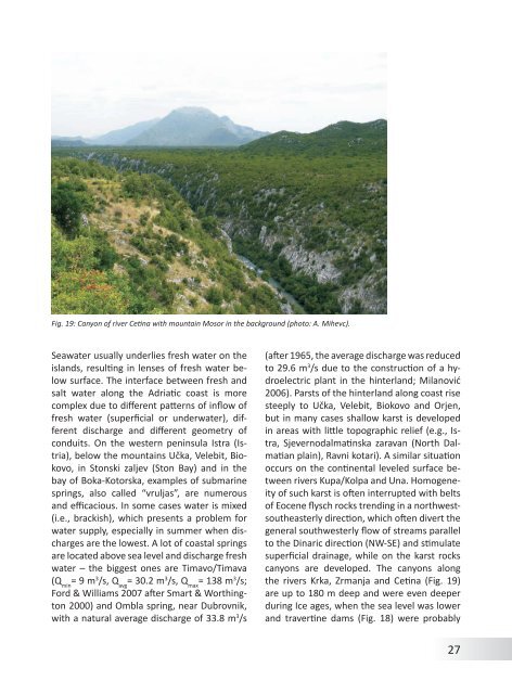
Fig. 19: Canyon <strong>of</strong> river Cetina with mountain Mosor in <strong>the</strong> background (photo: A. Mihevc).Seawater usually underlies fresh water on <strong>the</strong>islands, resulting in lenses <strong>of</strong> fresh water belowsurface. The interface between fresh andsalt water along <strong>the</strong> Adriatic coast is morecomplex due to different patterns <strong>of</strong> inflow <strong>of</strong>fresh water (superficial or underwater), differentdischarge and different geometry <strong>of</strong>conduits. On <strong>the</strong> western peninsula Istra (Istria),below <strong>the</strong> mountains Učka, Velebit, Biokovo,in Stonski zaljev (Ston Bay) and in <strong>the</strong>bay <strong>of</strong> Boka-Kotorska, examples <strong>of</strong> submarinesprings, also called “vruljas”, are numerousand efficacious. In some cases water is mixed(i.e., brackish), which presents a problem forwater supply, especially in summer when dischargesare <strong>the</strong> lowest. A lot <strong>of</strong> coastal springsare located above sea level and discharge freshwater – <strong>the</strong> biggest ones are Timavo/Timava(Q min= 9 m 3 /s, Q avg= 30.2 m 3 /s, Q max= 138 m 3 /s;Ford & Williams 2007 after Smart & Worthington2000) and Ombla spring, near Dubrovnik,with a natural average discharge <strong>of</strong> 33.8 m 3 /s(after 1965, <strong>the</strong> average discharge was reducedto 29.6 m 3 /s due to <strong>the</strong> construction <strong>of</strong> a hydroelectricplant in <strong>the</strong> hinterland; Milanović2006). Parsts <strong>of</strong> <strong>the</strong> hinterland along coast risesteeply to Učka, Velebit, Biokovo and Orjen,but in many cases shallow karst is developedin areas with little topographic relief (e.g., Istra,Sjevernodalmatinska zaravan (North Dalmatianplain), Ravni kotari). A similar situationoccurs on <strong>the</strong> continental leveled surface betweenrivers Kupa/Kolpa and Una. Homogeneity<strong>of</strong> such karst is <strong>of</strong>ten interrupted with belts<strong>of</strong> Eocene flysch rocks trending in a northwestsou<strong>the</strong>asterlydirection, which <strong>of</strong>ten divert <strong>the</strong>general southwesterly flow <strong>of</strong> streams parallelto <strong>the</strong> <strong>Dinaric</strong> direction (NW-SE) and stimulatesuperficial drainage, while on <strong>the</strong> karst rockscanyons are developed. The canyons along<strong>the</strong> rivers Krka, Zrmanja and Cetina (Fig. 19)are up to 180 m deep and were even deeperduring Ice ages, when <strong>the</strong> sea level was lowerand travertine dams (Fig. 18) were probably27
absent. Downstreamparts <strong>of</strong> <strong>the</strong> canyonsare submerged dueto <strong>the</strong> tufa dams and<strong>the</strong> rise in sea level at<strong>the</strong> beginning <strong>of</strong> Holocene.In Istria, <strong>the</strong>canyons <strong>of</strong> <strong>the</strong> riversMirna and Raša areshallower but alsopartly submergedat <strong>the</strong> downstreamends.The most characteristichydro-geomorphicphenomena<strong>of</strong> <strong>the</strong> continentalmountainous karstare high plateaus andkarst poljes. The main Fig. 20: Spring <strong>of</strong> river Buna (photo: M. Prelovšek).ridge <strong>of</strong> continentalmountainous karst lies above 612 m a.s.l. Thewidth continental mountainous karst rangesbetween 30 to 110 km (Šarin 1984). The transition<strong>from</strong> <strong>the</strong> southwestern coastal Adriatickarst can be double this width in places. Insome parts <strong>of</strong> Adriatic coast, Dinarsko gorovjerise <strong>from</strong> <strong>the</strong> coast very steeply without leveledBesides Ljubljanica springs (Q min= 4.3 m 3 /s,Q avg= 39 m 3 /s, Q max= 132 m 3 /s; Gospodarič &Habič 1976), <strong>the</strong> most efficacious springs in<strong>Dinaric</strong> karst are located in this area (Fig. 16on page 24: Buna spring (Q min= 3.0 m 3 /s,Q avg= 23.7 m 3 /s, Q max= 123 m 3 /s; Fig. 20), Bunicaspring (Q min= 0.7 m 3 /s, Q avg= 20.3 m 3 /s,transition (Učka, Velebit, Biokovo, Orjen, Q max= 207 m 3 /s) and Trebišnjica springLovčen). In such areas, water is drained verticallythrough vadose zones up to 1,350 mdeep and <strong>of</strong>ten discharges in vruljas along <strong>the</strong>Adriatic coast. Behind Istra and Sjevernodalmatinskazaravan, <strong>the</strong> rise is more gradual. Ineastern Herzegovina, <strong>the</strong> rise in elevation goesthrough several karst overflow poljes, where<strong>the</strong> lowest are in southwest and <strong>the</strong> highestin nor<strong>the</strong>ast. Water appears and disappearshere several times, <strong>from</strong> <strong>the</strong> highest Gatačkopolje and Nevesinjsko polje (Nevesinje polje))through Cerničko (Cernica polje), Fatničko(Fatnica polje), Dabarsko (Dabar polje), Ljubijsko(Ljubinje polje) and Ljubomirsko polje(Ljubomir polje) to Popovo polje and finally to<strong>the</strong> spring Ombla at Adriatic coast and springsalong <strong>the</strong> river Neretva (Milanović 2006).(Q min= 2 m 3 /s, Q avg= 80 m 3 /s, Q max> 800 m 3 /s;Milanović 2006; Ford & Williams 2007 afterMilanović 2000). Similar topography and hydrologicalsystems have developed in westBosnia and Herzegovina. Underground waterflow between karst poljes can be directed ei<strong>the</strong>rperpendicular to <strong>the</strong> main ridge <strong>of</strong> Dinarskogorovje (this means also perpendicular to<strong>the</strong> smaller ridges and karst poljes –e.g., westernand eastern Herzegovina, <strong>the</strong> higher part<strong>of</strong> Slovene Dolenjska) or parallel to it (part <strong>of</strong>Ljubljanica basin, NE <strong>of</strong> Velebit). Some tectonicwindows <strong>of</strong> older (Paleozoic) impervious,or less permeable, rocks enhance superficialrun<strong>of</strong>f that drains into ponors (e.g., NE <strong>of</strong> Velebit,central Bosnia), but in very rare cases riverscan flow across Dinarsko gorovje (Neretva,28
- Page 2 and 3: Andrej Mihevc, Mitja Prelovšek, Na
- Page 4 and 5: ContentsGeographical Position and G
- Page 7 and 8: Fig. 2: Coastal part of Dinaric kar
- Page 9 and 10: ogy started. In 1531 a lawyer from
- Page 11 and 12: include numerous data and general o
- Page 13 and 14: GeologyNadja Zupan HajnaThe Dinaric
- Page 15 and 16: ceous. The final disintegration of
- Page 17 and 18: Fig. 11: Locations of Jelar Breccia
- Page 19 and 20: ClimateMitja PrelovšekThe Dinaric
- Page 21 and 22: 311 mm/a; Zaninović 2008) and incr
- Page 23 and 24: 24Fig. 16: Spatial distribution of
- Page 25: ocks (such as Eocene flysch, Lower
- Page 29 and 30: GeomorphologyAndrej MihevcIn folk l
- Page 31 and 32: long. They are smoother especially
- Page 33 and 34: is now depositing. Best known are t
- Page 35 and 36: Structural poljes are dominated by
- Page 37 and 38: Fig. 28: Typical dolines of Dinaric
- Page 39 and 40: the disintegrated collapsed rock at
- Page 41 and 42: on Northern Velebit, where three ca
- Page 43 and 44: Land UseNadja Zupan Hajna, Andrej M
- Page 45 and 46: for ‘bare limestone desert’ -th
- Page 47 and 48: Fig. 38: Grančarevo dam in the upp
- Page 49 and 50: KrasThe Kras is a distinct plateau,
- Page 51 and 52: in this part of the Kras (Mihevc 20
- Page 53 and 54: dolomite barrier along the Idrija w
- Page 55 and 56: of Dolenjska (Gams, 1974; Kranjc, 1
- Page 57 and 58: Fig. 44: Blind valleys of Matarsko
- Page 59 and 60: ly several dozen meters deep. Shaft
- Page 61 and 62: smaller than the higher ones. The r
- Page 63 and 64: tion in the Divaški kras (Mihevc 1
- Page 65 and 66: Use of Karst and its ProtectionThe
- Page 67 and 68: Gams, I., Vrišer, I. (Eds.), 1998:
- Page 69 and 70: lems.- Dela 38, Raziskovalni center