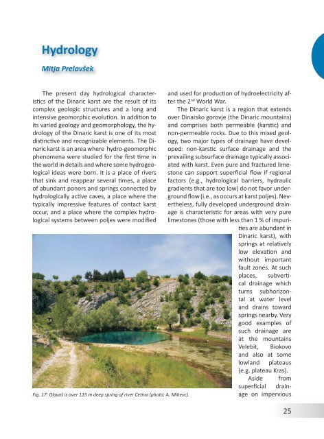
HydrologyMitja PrelovšekThe present day hydrological characteristics<strong>of</strong> <strong>the</strong> <strong>Dinaric</strong> karst are <strong>the</strong> result <strong>of</strong> itscomplex geologic structures and a long andintensive geomorphic evolution. In addition toits varied geology and geomorphology, <strong>the</strong> hydrology<strong>of</strong> <strong>the</strong> <strong>Dinaric</strong> karst is one <strong>of</strong> its mostdistinctive and recognizable elements. The <strong>Dinaric</strong>karst is an area where hydro-geomorphicphenomena were studied for <strong>the</strong> first time in<strong>the</strong> world in details and where some hydrogeologicalideas were born. It is a place <strong>of</strong> riversthat sink and reappear several times, a place<strong>of</strong> abundant ponors and springs connected byhydrologically active caves, a place where <strong>the</strong>typically impressive features <strong>of</strong> contact karstoccur, and a place where <strong>the</strong> complex hydrologicalsystems between poljes were modifiedFig. 17: Glavaš is over 115 m deep spring <strong>of</strong> river Cetina (photo: A. Mihevc).and used for production <strong>of</strong> hydroelectricity after<strong>the</strong> 2 nd World War.The <strong>Dinaric</strong> karst is a region that extendsover Dinarsko gorovje (<strong>the</strong> <strong>Dinaric</strong> mountains)and comprises both permeable (karstic) andnon-permeable rocks. Due to this mixed geology,two major types <strong>of</strong> drainage have developed:non-karstic surface drainage and <strong>the</strong>prevailing subsurface drainage typically associatedwith karst. Even pure and fractured limestonecan support superficial flow if regionalfactors (e.g., hydrological barriers, hydraulicgradients that are too low) do not favor undergroundflow (i.e., as occurs at karst poljes). Never<strong>the</strong>less,fully developed underground drainageis characteristic for areas with very purelimestones (those with less than 1 % <strong>of</strong> impuritiesare abundant in<strong>Dinaric</strong> karst), withsprings at relativelylow elevation andwithout importantfault zones. At suchplaces, subverticaldrainage whichturns subhorizontalat water leveland drains towardsprings nearby. Verygood examples <strong>of</strong>such drainage areat <strong>the</strong> mountainsVelebit, Biokovoand also at somelowland plateaus(e.g. plateau Kras).Aside <strong>from</strong>superficial drainageon impervious25
ocks (such as Eocene flysch, Lower Mesozoicand Upper Paleozoic rocks), very extensive areas<strong>of</strong> <strong>the</strong> Inner Dinarides exhibit <strong>the</strong> fluviokarstictype <strong>of</strong> drainage. This type <strong>of</strong> drainageis especially characteristic for dolomite that isnot able to transfer all <strong>the</strong> water undergrounddue to rapid superficial wea<strong>the</strong>ring, too highfractionation or too slow solubility. In suchcases, a portion <strong>of</strong> water flows on <strong>the</strong> surface,especially during heavy rain or intensive melting<strong>of</strong> snow in springtime, but <strong>the</strong> rest can flowunderground toward springs at <strong>the</strong> sides <strong>of</strong>deep valleys. Fluviokarstic drainage is impressivelydeveloped in <strong>the</strong> sou<strong>the</strong>astern part <strong>of</strong><strong>the</strong> <strong>Dinaric</strong> karst where dolomites are widelyexposed. Here, <strong>the</strong> rivers Tara and Piva haveformed canyons exceeding 1,000 m in depth.At <strong>the</strong> interfaces between permeable andimpermeable rocks, impressive contact karstdeveloped where <strong>the</strong> superficial rivers encounterpermeable karstic rocks. At <strong>the</strong>se geologicalcontacts, superficial streams stronglyinfluence <strong>the</strong> characteristics <strong>of</strong> undergroundFig. 18: Travertine dams are building for impresive waterfalls along Croatian Krka river(photo: A. Mihevc).26hydrology, especially with respect to point recharge,flow regime and high sediment load.During <strong>the</strong>ir long history <strong>of</strong> sinking, <strong>the</strong>se riversand streams have formed big, and still hydrologicallyactive, underground passages, aswell as blind valleys and collapse dolines. One<strong>of</strong> <strong>the</strong> best examples <strong>of</strong> such a sinking riveris <strong>the</strong> Reka, which sinks into Škocjanske jame(Škocjan Caves). Concentration <strong>of</strong> water isalso characteristic for some sinks at <strong>the</strong> downstreamends <strong>of</strong> karst poljes, where long epiphreaticcave systems have been developed(i.e. Postojnska jama, Vjetrenica).Based on described lithological factors,major geomorphic features and hydrologicalcharacteristics, <strong>the</strong> <strong>Dinaric</strong> karst is usually hydrologicallydivided into three spatial regions(Gams 1974; Herak et al. 1969; Šarin 1984):low coastal and insular Adriatic karst, continentalmountainous karst and low nor<strong>the</strong>asternand high sou<strong>the</strong>astern inland karst. All <strong>of</strong><strong>the</strong>se hydrogeological regions are parallel toAdriatic Sea.Low coastal andinsular Adriatic karst,formed mainly in Cretaceous-Tertiaryrocks,is characteristic fornearly all <strong>of</strong> <strong>the</strong> islandsalong <strong>the</strong> Croatiancoast, <strong>the</strong> nor<strong>the</strong>asterncoastal part <strong>of</strong> Italy(northwest <strong>of</strong> Trieste/Trst), <strong>the</strong> coastal area<strong>of</strong> Croatia, Bosnia andHerzegovina and Montenegro.In <strong>Slovenia</strong>,<strong>the</strong> coastal area isformed in Eocene flyschrocks and is <strong>the</strong>reforenon-karstic. Themain characteristic <strong>of</strong><strong>the</strong> low coastal andinsular Adriatic karstis <strong>the</strong> contact <strong>of</strong> freshwater with seawater.
- Page 2 and 3: Andrej Mihevc, Mitja Prelovšek, Na
- Page 4 and 5: ContentsGeographical Position and G
- Page 7 and 8: Fig. 2: Coastal part of Dinaric kar
- Page 9 and 10: ogy started. In 1531 a lawyer from
- Page 11 and 12: include numerous data and general o
- Page 13 and 14: GeologyNadja Zupan HajnaThe Dinaric
- Page 15 and 16: ceous. The final disintegration of
- Page 17 and 18: Fig. 11: Locations of Jelar Breccia
- Page 19 and 20: ClimateMitja PrelovšekThe Dinaric
- Page 21 and 22: 311 mm/a; Zaninović 2008) and incr
- Page 23: 24Fig. 16: Spatial distribution of
- Page 27 and 28: absent. Downstreamparts of the cany
- Page 29 and 30: GeomorphologyAndrej MihevcIn folk l
- Page 31 and 32: long. They are smoother especially
- Page 33 and 34: is now depositing. Best known are t
- Page 35 and 36: Structural poljes are dominated by
- Page 37 and 38: Fig. 28: Typical dolines of Dinaric
- Page 39 and 40: the disintegrated collapsed rock at
- Page 41 and 42: on Northern Velebit, where three ca
- Page 43 and 44: Land UseNadja Zupan Hajna, Andrej M
- Page 45 and 46: for ‘bare limestone desert’ -th
- Page 47 and 48: Fig. 38: Grančarevo dam in the upp
- Page 49 and 50: KrasThe Kras is a distinct plateau,
- Page 51 and 52: in this part of the Kras (Mihevc 20
- Page 53 and 54: dolomite barrier along the Idrija w
- Page 55 and 56: of Dolenjska (Gams, 1974; Kranjc, 1
- Page 57 and 58: Fig. 44: Blind valleys of Matarsko
- Page 59 and 60: ly several dozen meters deep. Shaft
- Page 61 and 62: smaller than the higher ones. The r
- Page 63 and 64: tion in the Divaški kras (Mihevc 1
- Page 65 and 66: Use of Karst and its ProtectionThe
- Page 67 and 68: Gams, I., Vrišer, I. (Eds.), 1998:
- Page 69 and 70: lems.- Dela 38, Raziskovalni center