Case Studies from the Dinaric Karst of Slovenia
Case Studies from the Dinaric Karst of Slovenia
Case Studies from the Dinaric Karst of Slovenia

Create successful ePaper yourself
Turn your PDF publications into a flip-book with our unique Google optimized e-Paper software.
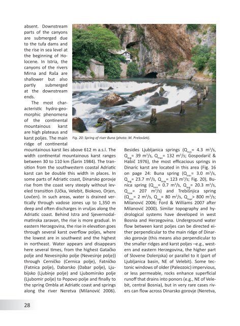
absent. Downstreamparts <strong>of</strong> <strong>the</strong> canyonsare submerged dueto <strong>the</strong> tufa dams and<strong>the</strong> rise in sea level at<strong>the</strong> beginning <strong>of</strong> Holocene.In Istria, <strong>the</strong>canyons <strong>of</strong> <strong>the</strong> riversMirna and Raša areshallower but alsopartly submergedat <strong>the</strong> downstreamends.The most characteristichydro-geomorphicphenomena<strong>of</strong> <strong>the</strong> continentalmountainous karstare high plateaus andkarst poljes. The main Fig. 20: Spring <strong>of</strong> river Buna (photo: M. Prelovšek).ridge <strong>of</strong> continentalmountainous karst lies above 612 m a.s.l. Thewidth continental mountainous karst rangesbetween 30 to 110 km (Šarin 1984). The transition<strong>from</strong> <strong>the</strong> southwestern coastal Adriatickarst can be double this width in places. Insome parts <strong>of</strong> Adriatic coast, Dinarsko gorovjerise <strong>from</strong> <strong>the</strong> coast very steeply without leveledBesides Ljubljanica springs (Q min= 4.3 m 3 /s,Q avg= 39 m 3 /s, Q max= 132 m 3 /s; Gospodarič &Habič 1976), <strong>the</strong> most efficacious springs in<strong>Dinaric</strong> karst are located in this area (Fig. 16on page 24: Buna spring (Q min= 3.0 m 3 /s,Q avg= 23.7 m 3 /s, Q max= 123 m 3 /s; Fig. 20), Bunicaspring (Q min= 0.7 m 3 /s, Q avg= 20.3 m 3 /s,transition (Učka, Velebit, Biokovo, Orjen, Q max= 207 m 3 /s) and Trebišnjica springLovčen). In such areas, water is drained verticallythrough vadose zones up to 1,350 mdeep and <strong>of</strong>ten discharges in vruljas along <strong>the</strong>Adriatic coast. Behind Istra and Sjevernodalmatinskazaravan, <strong>the</strong> rise is more gradual. Ineastern Herzegovina, <strong>the</strong> rise in elevation goesthrough several karst overflow poljes, where<strong>the</strong> lowest are in southwest and <strong>the</strong> highestin nor<strong>the</strong>ast. Water appears and disappearshere several times, <strong>from</strong> <strong>the</strong> highest Gatačkopolje and Nevesinjsko polje (Nevesinje polje))through Cerničko (Cernica polje), Fatničko(Fatnica polje), Dabarsko (Dabar polje), Ljubijsko(Ljubinje polje) and Ljubomirsko polje(Ljubomir polje) to Popovo polje and finally to<strong>the</strong> spring Ombla at Adriatic coast and springsalong <strong>the</strong> river Neretva (Milanović 2006).(Q min= 2 m 3 /s, Q avg= 80 m 3 /s, Q max> 800 m 3 /s;Milanović 2006; Ford & Williams 2007 afterMilanović 2000). Similar topography and hydrologicalsystems have developed in westBosnia and Herzegovina. Underground waterflow between karst poljes can be directed ei<strong>the</strong>rperpendicular to <strong>the</strong> main ridge <strong>of</strong> Dinarskogorovje (this means also perpendicular to<strong>the</strong> smaller ridges and karst poljes –e.g., westernand eastern Herzegovina, <strong>the</strong> higher part<strong>of</strong> Slovene Dolenjska) or parallel to it (part <strong>of</strong>Ljubljanica basin, NE <strong>of</strong> Velebit). Some tectonicwindows <strong>of</strong> older (Paleozoic) impervious,or less permeable, rocks enhance superficialrun<strong>of</strong>f that drains into ponors (e.g., NE <strong>of</strong> Velebit,central Bosnia), but in very rare cases riverscan flow across Dinarsko gorovje (Neretva,28