Case Studies from the Dinaric Karst of Slovenia
Case Studies from the Dinaric Karst of Slovenia
Case Studies from the Dinaric Karst of Slovenia

Create successful ePaper yourself
Turn your PDF publications into a flip-book with our unique Google optimized e-Paper software.
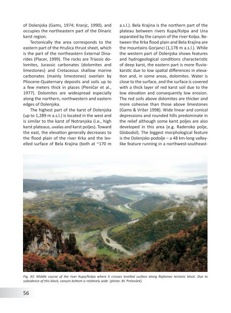
<strong>of</strong> Dolenjska (Gams, 1974; Kranjc, 1990), andoccupies <strong>the</strong> nor<strong>the</strong>astern part <strong>of</strong> <strong>the</strong> <strong>Dinaric</strong>karst region.Tectonically <strong>the</strong> area corresponds to <strong>the</strong>eastern part <strong>of</strong> <strong>the</strong> Hrušica thrust sheet, whichis <strong>the</strong> part <strong>of</strong> <strong>the</strong> nor<strong>the</strong>astern External Dinarides(Placer, 1999). The rocks are Triassic dolomites,Jurassic carbonates (dolomites andlimestones) and Cretaceous shallow marinecarbonates (mainly limestones) overlain byPliocene-Quaternary deposits and soils up toa few meters thick in places (Pleničar et al.,1977). Dolomites are widespread especiallyalong <strong>the</strong> nor<strong>the</strong>rn, northwestern and easternedges <strong>of</strong> Dolenjska.The highest part <strong>of</strong> <strong>the</strong> karst <strong>of</strong> Dolenjska(up to 1,289 m a.s.l.) is located in <strong>the</strong> west andis similar to <strong>the</strong> karst <strong>of</strong> Notranjska (i.e., highkarst plateaus, uvalas and karst poljes). Toward<strong>the</strong> east, <strong>the</strong> elevation generally decreases to<strong>the</strong> flood plain <strong>of</strong> <strong>the</strong> river Krka and <strong>the</strong> levelledsurface <strong>of</strong> Bela Krajina (both at ~170 ma.s.l.). Bela Krajina is <strong>the</strong> nor<strong>the</strong>rn part <strong>of</strong> <strong>the</strong>plateau between rivers Kupa/Kolpa and Unaseparated by <strong>the</strong> canyon <strong>of</strong> <strong>the</strong> river Kolpa. Between<strong>the</strong> Krka flood plain and Bela Krajina are<strong>the</strong> mountains Gorjanci (1,178 m a.s.l.). While<strong>the</strong> western part <strong>of</strong> Dolenjska shows featuresand hydrogeological conditions characteristic<strong>of</strong> deep karst, <strong>the</strong> eastern part is more fluviokarsticdue to low spatial differences in elevationand, in some areas, dolomites. Water isclose to <strong>the</strong> surface, and <strong>the</strong> surface is coveredwith a thick layer <strong>of</strong> red karst soil due to <strong>the</strong>low elevation and consequently low erosion.The red soils above dolomites are thicker andmore cohesive than those above limestones(Gams & Vrišer 1998). Wide linear and conicaldepressions and rounded hills predominate in<strong>the</strong> relief although some karst poljes are alsodeveloped in this area (e.g. Radensko polje,Globodol). The biggest morphological featureis <strong>the</strong> Dolenjsko podolje – a 48 km-long valleylikefeature running in a northwest-sou<strong>the</strong>ast-Fig. 43: Middle course <strong>of</strong> <strong>the</strong> river Kupa/Kolpa where it crosses levelled surface along Rajhenav tectonic block. Due tosubsidence <strong>of</strong> this block, canyon bottom is relatively wide (photo: M. Prelovšek).56