Case Studies from the Dinaric Karst of Slovenia
Case Studies from the Dinaric Karst of Slovenia
Case Studies from the Dinaric Karst of Slovenia

You also want an ePaper? Increase the reach of your titles
YUMPU automatically turns print PDFs into web optimized ePapers that Google loves.
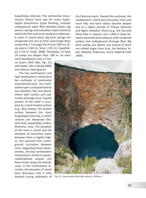
Kupa/Kolpa, Morača). The continental mountainous<strong>Dinaric</strong> karst was for many hydrologicalphenomena (polje flooding, complexunderground water flow between poljes, bigponors, springs and estavellas, hydro technicalworks) <strong>the</strong> first area to be studied or extensivelyused. In recent years, big karst springs arerecognized also due to <strong>the</strong>ir surprisingly deepsumps (Fig. 17 on page 25) <strong>of</strong> Una (-205 m), Divjejezero (-160 m), Sinac (-155 m), Kupa/Kolpa(-154 m; Knab, 2008). Nowadays, at least14 sumps are deeper than -100 m. An evenmore exceptional case is Crvenojezero (Red lake; Fig. 21)with depth -281 m (Knab 2008)and without clear genesis.The low nor<strong>the</strong>astern andhigh sou<strong>the</strong>astern inland karstlies nor<strong>the</strong>ast <strong>of</strong> continentalmountainous karst. The nor<strong>the</strong>asternpart is characterized bylow elevation hills and plains,where both surface and subsurfacedrainage occur. A greatportion <strong>of</strong> <strong>the</strong> relief is occupiedby a karst-leveled surface(e.g., Bela Krajina, <strong>the</strong> leveledsurface between <strong>the</strong> riversKupa/Kolpa and Una), in whichcanyons are deepened (SloveneKrka, Kupa/Kolpa, Dobra,Mrežnica, Una). The elevation<strong>of</strong> <strong>the</strong> rivers is similar and <strong>the</strong>elevation <strong>of</strong> subsurface waterbetween <strong>the</strong>m is slightly higher;this prevents <strong>from</strong> undergroundcirculation betweenrivers. Regarding <strong>the</strong>se characteristics,<strong>the</strong> low nor<strong>the</strong>asterninland karst is similar to Sjevernodalmatinskazaravan andRavni kotari along <strong>the</strong> Adriaticcoast. In <strong>the</strong> nor<strong>the</strong>astern direction,<strong>the</strong> elevation <strong>of</strong> inlandkarst decreases until it sinksbeneath young sediments <strong>of</strong><strong>the</strong> Panonian basin. Toward <strong>the</strong> sou<strong>the</strong>ast, <strong>the</strong>sou<strong>the</strong>astern inland karst becomes more andmore hilly and karst valleys become deeperdue to a higher portion <strong>of</strong> Triassic dolomiteand higher elevation. Rivers (e.g., <strong>the</strong> Tara andPliva) flow in canyons over 1,000 m deep betweendissected karst plateaus with combinedsurface and underground drainage flow. Bigkarst springs are absent, but several <strong>of</strong> <strong>the</strong>mcan initiate larger rivers (e.g., <strong>the</strong> Neretva, Vrbas,Miljacka, Željeznica, Usora; Papeš & Srdić1969).Fig. 21: Crveno jezero (Red lake; photo: A. Mihevc).29