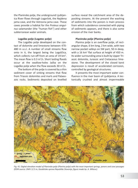
<strong>the</strong> Planinsko polje, <strong>the</strong> underground LjubljanicaRiver flows through Logarček, <strong>the</strong> Najdenajama cave, and <strong>the</strong> Vetrovna jama cave. Thesecaves provide a habitat for <strong>the</strong> Proteus anguinussalamander (<strong>the</strong> “human fish”) and o<strong>the</strong>rsubterranean water animals.Logaško polje (Logatec polje)The Logaško polje developed on <strong>the</strong> contact<strong>of</strong> dolomite and limestone between 470-480 m a.s.l. A number <strong>of</strong> small streams flowonto in it, <strong>the</strong> largest being <strong>the</strong> Logaščica,which collects run-<strong>of</strong>f <strong>from</strong> an area <strong>of</strong> 19 km 2 .The mean flow is 0.3 m 3 /s. Short lasting floodsoccur at <strong>the</strong> swallow-holes Jačka on <strong>the</strong>Logaško polje when <strong>the</strong> flow exceeds 30 m 3 /s.The bottom <strong>of</strong> <strong>the</strong> polje is covered by a thinsediment cover <strong>of</strong> sinking streams that flow<strong>from</strong> Triassic dolomites and marls and Palaeozoicrocks. Sediments deposited on levelledsurface reveal <strong>the</strong> catchment area <strong>of</strong> <strong>the</strong> depositingstreams. At <strong>the</strong> present <strong>the</strong> washing<strong>of</strong> sediments into <strong>the</strong> ponors is main process<strong>from</strong> which subsidence connected with piping<strong>of</strong> sediments appears, and <strong>the</strong>re is also someerosion <strong>of</strong> <strong>the</strong> river banks.Planinsko polje (Planina polje)Planina polje is an overflow polje, <strong>of</strong> rectangularshape, 6 km long, 2 km wide, with twonarrow pocket valleys on SW part, 50 m deep,with a 16 km 2 flat surface at height <strong>of</strong> 450 m.Its wider surrounding area is built by Upper Triassicdolomite, Jurassic and Cretaceous limestone.The development <strong>of</strong> <strong>the</strong> closed karstdepression is result <strong>of</strong> accelerated corrosion,controlled by geological structures.It presents <strong>the</strong> most important water confluencein <strong>the</strong> river basin <strong>of</strong> Ljubljanica. A tectonicallycrushed and almost impermeableFig. 41: Digital elevation model <strong>of</strong> Planinsko polje (Planina polje) with <strong>the</strong> most important springs, ponors and cave passages(DEM source: DMV 12.5 m, Geodetska uprava Republike Slovenije; figure made by: A. Mihevc).53
dolomite barrier along <strong>the</strong> Idrija wrench faultzone, which crosses <strong>the</strong> polje, forces <strong>the</strong> karstwaters to overflow <strong>from</strong> higher karstified limestonebackground to <strong>the</strong> surface, and aftercrossing Planinsko polje toward <strong>the</strong> nor<strong>the</strong>ast<strong>the</strong>y can sink into <strong>the</strong> underground again. Theprincipal Unica springs, with mean annual discharge24 m 3 /s (min. 0.3 m 3 /s, max. 100 m 3 /s),are situated in <strong>the</strong> sou<strong>the</strong>rn polje’s part in Cretaceouslimestone, where <strong>the</strong> confluence <strong>of</strong>waters <strong>from</strong> Cerknica, Javorniki Mt. and Pivkais located. Main spring is 6,656 m long cavePlaninska jama.The principal Unica swallow-holes are disposedat <strong>the</strong> nor<strong>the</strong>rn edge, where mostlymedium and high waters are sinking. At lowwaters <strong>the</strong> whole Unica is disappearing inswallow-holes at eastern polje’s border. Upto 160 m long ponor caves are known, but<strong>the</strong>re are several horizontal caves in vicinity<strong>of</strong> <strong>the</strong> polje, where water oscillations canbe observed. Larger caves behind <strong>the</strong> ponorsare over 5,110 m long Najdena jama cave andLogarček.Rakov ŠkocjanRakov Škocjan is a karst depression about1,5 km long and 200 m wide. It is situatedbelow <strong>the</strong> N side <strong>of</strong> Javorniki Mountain at elevationabout 500 m between Planinsko andCerkniško polje. Through <strong>the</strong> depression flows<strong>the</strong> permanent river Rak. The Rak springs<strong>from</strong> Zelške jame cave, bringing water <strong>from</strong>Cerkniško polje. Zelške jame are about 5 kmlong; <strong>the</strong> end <strong>of</strong> <strong>the</strong> cave is in huge collapsedoline Velika Šujca, where <strong>from</strong> <strong>the</strong> o<strong>the</strong>r side<strong>the</strong> Karlovica cave system ends. In Karlovicasystem is <strong>the</strong> main outflow <strong>from</strong> Cerkniškopolje. Numerous collapse dolines are situatedaround <strong>the</strong> entrance <strong>of</strong> Zelške jame. In one<strong>of</strong> <strong>the</strong>m <strong>the</strong> small natural bridge is present.Downstream, <strong>the</strong> valley widens and severalsprings bring additional water to <strong>the</strong> Rak River.The valley narrows at <strong>the</strong> Great Natural Bridgeand afterwards <strong>the</strong> Rak sinks into Tkalca jamacave, <strong>from</strong> where <strong>the</strong> water flows towards<strong>the</strong> cave Planinska jama at Planinsko polje.The connections <strong>of</strong> <strong>the</strong> Rak with water <strong>from</strong>Cerkniško polje and with <strong>the</strong> Unica springs atPlaninsko polje were proved by water tracing.From 1949 Rakov Škocjan has been a LandscapePark.Cerkniško polje (Cerknica polje)Cerkniško polje (Cerknica polje; Fig. 42) is<strong>the</strong> biggest karst polje in <strong>Slovenia</strong>. Often it iscalled just Cerkniško jezero (Lake <strong>of</strong> Cerknica),because <strong>of</strong> its regular floods, or intermittentlake. The intermittent lake covers 26 km 2 whenis full; it is 10.5 km long and almost 5 km wide.Its hydrological properties caused that alreadyin <strong>the</strong> beginning <strong>of</strong> New Age scholars <strong>from</strong> allround Europe were attracted to it. The lake becomesstill more known through <strong>the</strong> Valvasor’sdescription in 1689. Bottom <strong>of</strong> Cerkniško poljecovers 38 km 2 in elevation <strong>of</strong> about 550 m. Inflowsare on E, S, and partly on W polje’s side.The largest tributary to polje is Cerkniščica,drained about 45 km 2 large mostly dolomitecatchment area. The important karst springsare Žerovnica, Šteberščica and Stržen. Strženflows on <strong>the</strong> W side <strong>of</strong> polje towards <strong>the</strong>ponors in <strong>the</strong> middle <strong>of</strong> <strong>the</strong> polje, <strong>from</strong> wherewater flows directly to Ljubljanica springs, andtowards NW side <strong>of</strong> polje, <strong>from</strong> where <strong>the</strong> waterflows to Rakov Škocjan. From <strong>the</strong> foot <strong>of</strong>Javorniki mountain to <strong>the</strong> contact with dolomitein <strong>the</strong> polje bottom are 12 ponor caves.They are connected to Karlovica cave system,to which also <strong>the</strong> highest waters <strong>from</strong> poljeflows. The system <strong>the</strong>re is more <strong>the</strong> 7 km <strong>of</strong>passages. Passages are generally low, because<strong>the</strong>y are filled by alluvia. Thickness <strong>of</strong> alluviain Jamski zaliv, before <strong>the</strong> caves entrances, isabout 8 –15 m.Cerkniško polje is a karst polje developed in<strong>the</strong> important regional fault zone – Idrija fault.Idrija fault has <strong>the</strong> “<strong>Dinaric</strong>” direction (NW-SE);in <strong>the</strong> same fault zone are developed: Planinskopolje, Loško polje and Babno polje. Bottom<strong>of</strong> polje is formed on Upper Triasic dolomite,which is presented also on <strong>the</strong> N, E and SE side54
- Page 2 and 3: Andrej Mihevc, Mitja Prelovšek, Na
- Page 4 and 5: ContentsGeographical Position and G
- Page 7 and 8: Fig. 2: Coastal part of Dinaric kar
- Page 9 and 10: ogy started. In 1531 a lawyer from
- Page 11 and 12: include numerous data and general o
- Page 13 and 14: GeologyNadja Zupan HajnaThe Dinaric
- Page 15 and 16: ceous. The final disintegration of
- Page 17 and 18: Fig. 11: Locations of Jelar Breccia
- Page 19 and 20: ClimateMitja PrelovšekThe Dinaric
- Page 21 and 22: 311 mm/a; Zaninović 2008) and incr
- Page 23 and 24: 24Fig. 16: Spatial distribution of
- Page 25 and 26: ocks (such as Eocene flysch, Lower
- Page 27 and 28: absent. Downstreamparts of the cany
- Page 29 and 30: GeomorphologyAndrej MihevcIn folk l
- Page 31 and 32: long. They are smoother especially
- Page 33 and 34: is now depositing. Best known are t
- Page 35 and 36: Structural poljes are dominated by
- Page 37 and 38: Fig. 28: Typical dolines of Dinaric
- Page 39 and 40: the disintegrated collapsed rock at
- Page 41 and 42: on Northern Velebit, where three ca
- Page 43 and 44: Land UseNadja Zupan Hajna, Andrej M
- Page 45 and 46: for ‘bare limestone desert’ -th
- Page 47 and 48: Fig. 38: Grančarevo dam in the upp
- Page 49 and 50: KrasThe Kras is a distinct plateau,
- Page 51: in this part of the Kras (Mihevc 20
- Page 55 and 56: of Dolenjska (Gams, 1974; Kranjc, 1
- Page 57 and 58: Fig. 44: Blind valleys of Matarsko
- Page 59 and 60: ly several dozen meters deep. Shaft
- Page 61 and 62: smaller than the higher ones. The r
- Page 63 and 64: tion in the Divaški kras (Mihevc 1
- Page 65 and 66: Use of Karst and its ProtectionThe
- Page 67 and 68: Gams, I., Vrišer, I. (Eds.), 1998:
- Page 69 and 70: lems.- Dela 38, Raziskovalni center